Fort Griswold
|
Fort Griswold | |
 River or Lower battery. | |
| Location |
Bounded by Baker Ave., Smith St., Park Ave., Monument Ave., and Thames River Groton, Connecticut |
|---|---|
| Website | Fort Griswold Battlefield State Park |
| NRHP Reference # | 70000694 |
| Added to NRHP | October 6, 1970 |
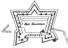
Fort Griswold is a former American defensive fortification in Groton, Connecticut named after Deputy Governor Matthew Griswold. The fort played a key role in the early stages of the American Revolutionary War, in correspondence with Fort Trumbull on the opposite side of the Thames River. Griswold served to defend the port of New London, a supply center for the Continental Army and friendly port for Connecticut-sanctioned privateers who attacked British ships.[1] The 17-acre site is maintained as Fort Griswold Battlefield State Park by the Connecticut Department of Energy and Environmental Protection.[2][3]
History
Construction of the fort was begun on 5 December 1775 in response to the outbreak of the American Revolution. It was completed in 1778 and was also called "Groton Fort".[4] It is located on a high hill with the ability to bombard ships entering the Thames River or the city of New London. About 100 feet below the main fort is a battery for additional guns which was originally built during the Revolutionary War and improved in the late 19th Century.
In September 1781, British troops under Benedict Arnold raided and burned New London in the Battle of Groton Heights. The British were well informed of the layout of the fort, and Arnold approached the harbor from such an angle that the fort's guns could not engage his fleet. Arnold's troops eventually made landfall and encountered resistance. Artillery barrages and musket fire brought somewhat heavy casualties to each side. The British eventually broke into the fort, and Colonel William Ledyard surrendered by handing his sword, hilt-first, to the commanding British officer—who took the sword and immediately thrust it through Colonel Ledyard. Arnold abandoned the fort soon after and left New London in flames.[5]
Later use
The fort was rebuilt and manned in several other conflicts, but the Battle of Groton Heights was its most prominent use. It was used during the War of 1812 by United States Navy sailors commanded by Commodore Stephen Decatur when Decatur's three-ship squadron was blockaded by a superior British force in 1814.
In the 1840s the fort's lower battery was rebuilt for 20 guns, initially 32-pounder and 24-pounder cannons.[6]
After the American Civil War, the lower battery of the fort was redesigned to mount 10-inch Rodman cannons. It was a subpost of Fort Trumbull for most of its use as a fort by the U.S. Army. It was never actively garrisoned after the Civil War and was under the care of an ordnance sergeant.
From 1863 to 1879, Fort Griswold was in the care of Ordnance Sergeant Mark Wentworth Smith, a Mexican-American War veteran who was wounded at the Battle of Chapultepec. Sergeant Smith died in 1879 at the age of 76. He was the oldest active duty enlisted soldier in the history of the U.S. Army.
After the Spanish–American War, Fort Griswold became obsolete when Fort H. G. Wright was established on Fishers Island as part of the Harbor Defenses of Long Island Sound.
Fort Griswold Battlefield State Park
The State of Connecticut now owns and operates the site as Fort Griswold Battlefield State Park. The site includes the restored earthwork battery, cannons, and a later period shot furnace and powder magazine. The grounds include several monuments and memorials to state residents who fought in different wars:
- The Groton Monument, a granite monument dedicated to the defenders who fell during the Battle of Groton Heights. Built between 1826 and 1830, the Monument stands 135 feet (41 m) tall with 166 steps.
- The adjacent Monument House Museum which features exhibits about the Revolutionary War and is operated by the Daughters of the American Revolution. Visitors can climb the monument and visit the museum from Memorial Day through Labor Day.
- The Ebenezer Avery House, which sheltered the wounded after the battle, is a Revolutionary-period historic house museum that is open for tours on summer weekends.[7]
See also
References
- ↑ "Fort Griswold". Michael Meals. Retrieved October 4, 2005.
- ↑ "Fort Griswold Battlefield State Park". State Parks and Forests. Connecticut Department of Energy and Environmental Protection. August 18, 2016. Retrieved September 20, 2016.
- ↑ "Appendix A: List of State Parks and Forests" (PDF). State Parks and Forests: Funding. Staff Findings and Recommendations. Connecticut General Assembly. January 23, 2014. p. A-1. Retrieved September 20, 2016.
- ↑ Roberts, Robert B. (1988). Encyclopedia of Historic Forts: The Military, Pioneer, and Trading Posts of the United States. New York: Macmillan. pp. 119–120. ISBN 0-02-926880-X.
- ↑ Constance Luyster, Administrative Trainee, State Historical Commission (July 30, 1970). "National Register of Historic Places Inventory Nomination Form: Fort Griswold" (PDF). National Park Service. and accompanying photographs
- ↑ History of Fort Griswold at Friends of Fort Griswold website
- ↑ "Avery House". Avery Memorial Association.
External links
| Wikisource has the text of a 1920 Encyclopedia Americana article about Fort Griswold. |
| Wikimedia Commons has media related to Fort Griswold. |
- Fort Griswold Battlefield State Park Connecticut Department of Energy and Environmental Protection
- Friends of Fort Griswold
Coordinates: 41°21′19″N 72°04′55″W / 41.3553°N 72.082°W
| Topics | |
|---|---|
| Lists by states |
|
| Lists by insular areas | |
| Lists by associated states | |
| Other areas | |
| |