Fingle Bridge
| Fingle Bridge | |
|---|---|
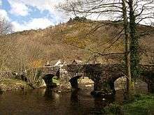
 Fingle bridge viewed from upstream, with the site of Prestonbury Castle behind | |
| Coordinates | 50°41′44″N 3°46′52″W / 50.69551°N 3.78100°WCoordinates: 50°41′44″N 3°46′52″W / 50.69551°N 3.78100°W |
| Carries | Unclassified road |
| Crosses | River Teign |
| Locale | Devon |
| Preceded by | Dogmarsh Bridge |
| Followed by | Clifford Bridge |
| Characteristics | |
| Design | Arch bridge |
| Material | Granite |
| Piers in water | 2 |
| History | |
| Construction end | 17th century |


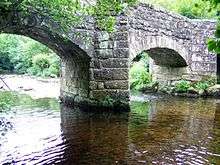
Fingle Bridge is a 17th-century stone arch bridge carrying an unclassified road over the River Teign near Drewsteignton, within Dartmoor National Park in Devon, England. This packhorse bridge has three arches and the two central piers are surrounded by triangular cutwaters extending upwards to form pedestrian refuges, and is a Grade II* listed building.
History
Fingle Bridge takes its name from Fingle Brook, a minor tributary which flows into the Teign adjacent to the bridge. Fingle is derived from the old English "fang", meaning to catch, a reference to the suitability of the stretch of river for fishing.[1]
The bridge sits in the base of the deep Teign Gorge, between the ancient hillforts of Prestonbury Castle 130 metres (430 ft)[2] above the river to the north and Cranbrook Castle 230 metres (750 ft)[2] above to the south,[3] and the bridge is built on the historic crossing point between the two.[4] In its early years the bridge was an important crossing over the Teign[5] used by packhorses transporting corn and wood products across the gorge,[6] although the track up to Cranbrook Castle is now an unmaintained byway such that the bridge leads only to a car park on the south side of the river for roadgoing vehicles, the bridge's function having been replaced by the larger and more accessible Dogmarsh Bridge further upstream on the A382 road.
The arches were repaired, believed by English Heritage to have been in the 19th century.[7]
In 1897 Jesse Ashplant founded the Fingle Bridge Tea Shelter on the north landing of the bridge, serving refreshments to the fishermen, tourists and grain carriers of the day.[8] This developed into the Anglers' Rest pub and was later renamed as the Fingle Bridge Inn.
In 1955 Fingle Bridge was designated a Grade II listed building,[7] reclassified in 1967 as Grade II*.[9]
Related buildings
Fingle Mill once stood 200 metres (660 ft) downstream, a corn mill recorded as being in operation as early as 1790 by the then owner of the bridge, George Ponsford,[10] powered by a now-defunct 500-metre (1,600 ft) long leat.
The track leading south to Cranbrook Castle is also the site of one of the Dartmoor crosses which is in the style of a granite slab with the cross engraved on it.[5]
References
- ↑ "Dartmoor at its very best". Plymouth Herald. 28 July 2012. Retrieved 3 March 2013.
- 1 2 Outdoor Leisure 28 - Dartmoor. Ordnance Survey. 1995.
- ↑ "The Rocky Teign Gorge to Fingle Bridge". The Automobile Association. Retrieved 26 February 2013.
- ↑ "Walk 35 The Two Moors Way, the Teign Gorge and Some Special Moor Stones" (PDF). Devon County Council. Retrieved 2 March 2013.
- 1 2 Maurice Daniel; Glenn Bearne (4 November 2001). "Fingle Bridge Cross". Dartmoor-crosses.org. Retrieved 2 March 2013.
- ↑ "Devon's rivers: The Teign". BBC. 6 February 2008. Retrieved 3 March 2013.
- 1 2 "Fingle Bridge, Moretonhampstead". BritishListedBuildings.co.uk. Retrieved 2 March 2013.
- ↑ "History of Fingle Bridge". Fingle Bridge Inn. Retrieved 3 March 2013.
- ↑ "Fingle Bridge, Drewsteignton". BritishListedBuildings.co.uk. Retrieved 4 March 2013.
- ↑ "FINGLE". Moretonhampstead History Society. 19 February 2013. Retrieved 3 March 2013.