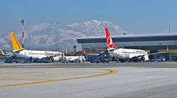
Van Ferit Melen Airport
| Van Ferit Melen Airport Ferit Melen Havalimanı | |||||||||||
|---|---|---|---|---|---|---|---|---|---|---|---|
 | |||||||||||
| Summary | |||||||||||
| Airport type | Public | ||||||||||
| Operator | General Directorate of State Airports Authority | ||||||||||
| Serves | Van | ||||||||||
| Location | Van, Turkey | ||||||||||
| Elevation AMSL | 5,480 ft / 1,670 m | ||||||||||
| Coordinates | 38°28′06″N 43°19′56″E / 38.46833°N 43.33222°E | ||||||||||
| Website | www.van.dhmi.gov.tr | ||||||||||
| Map | |||||||||||
 VAN Location of airport in Turkey | |||||||||||
| Runways | |||||||||||
| |||||||||||

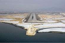
Aerial view of the airport.
Van Ferit Melen Airport (IATA: VAN, ICAO: LTCI) is an airport in Van, the city in eastern region of Turkey. It is named after the Turkish politician and former prime minister Ferit Melen (1906–1988).
Airlines and destinations
| Airlines | Destinations |
|---|---|
| Pegasus Airlines | Adana, Istanbul–Sabiha Gökçen, Izmir |
| Pouya Air | Urmia |
| SunExpress | Antalya, Izmir |
| Turkish Airlines | Istanbul–Atatürk |
| Turkish Airlines operated by AnadoluJet | Ankara, Istanbul–Sabiha Gökçen |
Traffic Statistics
| Year (months) | Domestic | % change | International | % change | Total | % change |
|---|---|---|---|---|---|---|
| 2014/9 | 902,060 | 2,413 | 904,473 | |||
| 2013 | 1,120,522 | 4,218 | 1,124,740 | |||
| 2012 | 999,908 | 1,959 | 1,001,867 | |||
| 2011 | 1,090,277 | 2,319 | 1,092,596 | |||
| 2010 | 890,382 | 1,674 | 892,056 | |||
| 2009 | 744,447 | 1,046 | 745,493 | |||
| 2008 | 581,142 | 4,177 | 585,319 | |||
| 2007 | 546,413 | 3,108 | 549,521 |
(*)Source: DHMI.gov.tr[3]
References
- ↑ Airport information for LTCI at World Aero Data. Data current as of October 2006.Source: DAFIF.
- ↑ Airport information for VAN at Great Circle Mapper. Source: DAFIF (effective October 2006).
- ↑ Statistics
External links
This article is issued from
Wikipedia.
The text is licensed under Creative Commons - Attribution - Sharealike.
Additional terms may apply for the media files.