Fargo, Arkansas
| Fargo, Arkansas | |
|---|---|
| Town | |
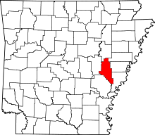
 Location of Fargo in Monroe County, Arkansas. | |
| Coordinates: 34°57′19″N 91°10′38″W / 34.95528°N 91.17722°WCoordinates: 34°57′19″N 91°10′38″W / 34.95528°N 91.17722°W | |
| Country | United States |
| State | Arkansas |
| County | Monroe |
| Area[1] | |
| • Total | 0.65 sq mi (1.69 km2) |
| • Land | 0.64 sq mi (1.64 km2) |
| • Water | 0.02 sq mi (0.05 km2) |
| Elevation | 200 ft (61 m) |
| Population (2010) | |
| • Total | 98 |
| • Estimate (2016)[2] | 87 |
| • Density | 137.01/sq mi (52.89/km2) |
| Time zone | Central (CST) (UTC-6) |
| • Summer (DST) | CDT (UTC-5) |
| FIPS code | 05-23140 |
| GNIS feature ID | 0057744 |
Fargo is a town in Monroe County, Arkansas, United States. The population was 118 at the 2000 census.
The defunct Missouri and North Arkansas Railroad provided freight and passenger service from Joplin, Missouri, to Helena, Arkansas, from 1906 to 1946. A six-mile link of the Helena and Northwestern Railroad from Cotton Plant in Woodruff County to Fargo was thereafter operated by the Cotton Plant-Fargo Railway, which joined with the St. Louis Southwestern Railway, popularly known as The Cotton Belt. This short line existed from 1952 into the 1970s, when it became the last portion of the old Missouri and North Arkansas Railroad to be abandoned[3]
Geography
Fargo is located at 34°57′19″N 91°10′38″W / 34.95528°N 91.17722°W (34.955140, -91.177179).[4]
According to the United States Census Bureau, the town has a total area of 1.7 km² (0.7 mi²). 1.7 km² (0.6 mi²) of it is land and 0.1 km² (0.04 mi²) of it (2.99%) is water.
Demographics
| Historical population | |||
|---|---|---|---|
| Census | Pop. | %± | |
| 1990 | 140 | — | |
| 2000 | 118 | −15.7% | |
| 2010 | 98 | −16.9% | |
| Est. 2016 | 87 | [2] | −11.2% |
2014 Estimate[6] | |||
As of the census[7] of 2000, there were 118 people, 41 households, and 31 families residing in the town. The population density was 70.1/km² (180.5/mi²). There were 50 housing units at an average density of 29.7/km² (76.5/mi²). The racial makeup of the town was 53.39% White, 45.76% Black or African American, 0.85% from other races.
There were 41 households out of which 46.3% had children under the age of 18 living with them, 53.7% were married couples living together, 19.5% had a female householder with no husband present, and 22.0% were non-families. 17.1% of all households were made up of individuals and 4.9% had someone living alone who was 65 years of age or older. The average household size was 2.88 and the average family size was 3.34.
In the town, the population was spread out with 38.1% under the age of 18, 6.8% from 18 to 24, 26.3% from 25 to 44, 19.5% from 45 to 64, and 9.3% who were 65 years of age or older. The median age was 29 years. For every 100 females there were 93.4 males. For every 100 females age 18 and over, there were 97.3 males.
The median income for a household in the town was $24,375, and the median income for a family was $28,750. Males had a median income of $19,583 versus $21,250 for females. The per capita income for the town was $8,634. There were 26.5% of families and 30.0% of the population living below the poverty line, including 31.8% of under eighteens and 72.7% of those over 64.
References
- ↑ "2016 U.S. Gazetteer Files". United States Census Bureau. Retrieved Jul 18, 2017.
- 1 2 "Population and Housing Unit Estimates". Retrieved June 9, 2017.
- ↑ "H. Glenn Mosenthin, "Missouri and North Arkansas Railroad"". encyclopediaofarkansas.net. Retrieved April 28, 2013.
- ↑ "US Gazetteer files: 2010, 2000, and 1990". United States Census Bureau. 2011-02-12. Retrieved 2011-04-23.
- ↑ "Census of Population and Housing". Census.gov. Archived from the original on May 12, 2015. Retrieved June 4, 2015.
- ↑ "Annual Estimates of the Resident Population for Incorporated Places: April 1, 2010 to July 1, 2014". Archived from the original on May 22, 2015. Retrieved June 4, 2015.
- ↑ "American FactFinder". United States Census Bureau. Archived from the original on 2013-09-11. Retrieved 2008-01-31.
