Eslohe
| Eslohe | ||
|---|---|---|
|
Timbered house in Eslohe | ||
| ||
 Eslohe | ||
Location of Eslohe within Hochsauerlandkreis district _in_HSK.svg.png)
 | ||
| Coordinates: 51°15′0″N 8°10′0″E / 51.25000°N 8.16667°ECoordinates: 51°15′0″N 8°10′0″E / 51.25000°N 8.16667°E | ||
| Country | Germany | |
| State | North Rhine-Westphalia | |
| Admin. region | Arnsberg | |
| District | Hochsauerlandkreis | |
| Government | ||
| • Mayor | Stephan Kersting (CDU) | |
| Area | ||
| • Total | 113.37 km2 (43.77 sq mi) | |
| Elevation | 404 m (1,325 ft) | |
| Population (2015-12-31)[1] | ||
| • Total | 8,942 | |
| • Density | 79/km2 (200/sq mi) | |
| Time zone | CET/CEST (UTC+1/+2) | |
| Postal codes | 59889 | |
| Dialling codes | 02973 | |
| Vehicle registration | HSK | |
| Website | www.eslohe.de | |

.svg.png)
Eslohe
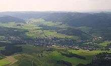
Eslohe is a municipality in the Hochsauerland district, in North Rhine-Westphalia, Germany.
Geography
Eslohe is situated approximately 25 km south-west of Meschede.
Neighbouring municipalities
Division of the town
After the local government reforms of 1975 Eslohe consists of the following districts:
|
|
|
|
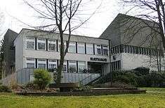
Eslohe Town hall (Rathaus)
Twin Towns
References
- ↑ "Amtliche Bevölkerungszahlen". Landesbetrieb Information und Technik NRW (in German). 18 July 2016.
External links
- Official site (in German)
| Wikimedia Commons has media related to Eslohe. |
Towns and municipalities in Hochsauerland | ||
|---|---|---|
This article is issued from
Wikipedia.
The text is licensed under Creative Commons - Attribution - Sharealike.
Additional terms may apply for the media files.