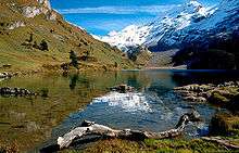
Engstlensee
| Engstlensee | |
|---|---|
 | |
| Location | Innertkirchen, Bernese Oberland |
| Coordinates | 46°46′22″N 8°21′25″E / 46.77278°N 8.35694°ECoordinates: 46°46′22″N 8°21′25″E / 46.77278°N 8.35694°E |
| Type | reservoir, natural lake |
| Basin countries | Switzerland |
| Surface area | 0.44 km2 (0.17 sq mi) |
| Max. depth | 49 m (161 ft) |
| Water volume | 10.7 million cubic metres (8,700 acre·ft) |
| Surface elevation | 1,850.8 m (6,072 ft) |
Engstlensee is a natural lake used as a reservoir in the municipality of Innertkirchen, Bernese Oberland, Switzerland. It is located near Joch Pass at an elevation of 1850 m. It can be reached by gondola and by foot from Titlis.
The reservoir has a volume of 10.7 million m³ whereof 2 million m³ are used for electricity production. The lake's surface area is 44 ha (110 acres).
The water of the Engstlensee passes through a tunnel in the neighbouring Gadmental valley before being used in the Fuhren, Hopflauenen and Innertkirchen power stations.[1]

Helga von Cramm, Engstlensee, c. 1880.
.jpg)

References
- ↑ "Engstlensee - Melchsee-Frutt". www.melchsee-frutt.ch. Retrieved 2015-08-24.
External links
- Lake Engstlen
 Media related to Engstlensee at Wikimedia Commons
This article is issued from
Wikipedia.
The text is licensed under Creative Commons - Attribution - Sharealike.
Additional terms may apply for the media files.