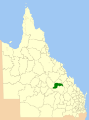
Shire of Emerald
| Shire of Emerald Queensland | |||||||||||||||
|---|---|---|---|---|---|---|---|---|---|---|---|---|---|---|---|
 Location within Queensland | |||||||||||||||
| Population | 14,161 | ||||||||||||||
| Council seat | Emerald | ||||||||||||||
| Region | Central Highlands | ||||||||||||||
 | |||||||||||||||
| Website | Shire of Emerald | ||||||||||||||
| |||||||||||||||
The Shire of Emerald is a former local government area in the Central Highlands region of Queensland, Australia. On 15 March 2008 the shires of Duaringa, Emerald, Bauhinia and Peak Downs were amalgamated to form the Central Highlands Region.[1] Its administrative centre is based around Emerald.
History
The Emerald Division was separated from the Peak Downs Division on 4 June 1902.
On 31 March 1903, Emerald Division became the Shire of Emerald.
Towns and localities
The Shire of Emerald included the following settlements:
|
Towns:
|
Gemfields area: |
Chairmen
- 1927: W. H. Harris [2]
References
- ↑ "Agency ID11030, Central Highlands Regional Council". Queensland State Archives. Retrieved 8 September 2013.
- ↑ Pugh, Theophilus Parsons (1927). Pugh's Almanac for 1927. Retrieved 13 June 2014.
External links
- Queensland Department of Local Government and Planning - Shire Directory
- University of Queensland: Queensland Places: Emerald Shire
Coordinates: 23°31′05.5″S 148°09′37.4″E / 23.518194°S 148.160389°E
This article is issued from
Wikipedia.
The text is licensed under Creative Commons - Attribution - Sharealike.
Additional terms may apply for the media files.