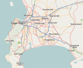
Elsie's River
| Elsie's River Elsiesrivier | |
|---|---|
 Elsie's River  Elsie's River  Elsie's River
| |
|
Location within Cape Town  Elsie's River | |
| Coordinates: 33°55′5″S 18°34′36″E / 33.91806°S 18.57667°ECoordinates: 33°55′5″S 18°34′36″E / 33.91806°S 18.57667°E | |
| Country | South Africa |
| Province | Western Cape |
| District | Metro Pole North |
| Municipality | City of Cape Town |
| Area[1] | |
| • Total | 5.52 km2 (2.13 sq mi) |
| Population (2011)[1] | |
| • Total | 42,479 |
| • Density | 7,700/km2 (20,000/sq mi) |
| Racial makeup (2011)[1] | |
| • Black African | 6.8% |
| • Coloured | 91.4% |
| • Indian/Asian | 0.5% |
| • White | 0.3% |
| • Other | 1.0% |
| First languages (2011)[1] | |
| • Afrikaans | 77.4% |
| • English | 19.2% |
| • Other | 3.3% |
| Postal code (street) | 7490 |
| PO box | 7480 |
Elsie's River (Elsiesrivier in Afrikaans) is a suburb of Cape Town, South Africa.
In 1980 the suburb, at the time restricted to coloured people, became the scene of bloodshed after a demonstration in support of the school boycott[2] became violent.
Two 15-year-olds were shot dead by police.[3]
Today Elsie's River has many public places such as libraries, supermarkets, and a civic hall.
History
Elsies's River was probably named after Elsje van Suurwaarde who farmed in the area in 1698.
Education
In Elsie's River there are eight schools, Elsie's River High School,The Range High School,The Range Primary School,Matroosfontein Primary School,Elsbury Primary School and J.S. Klopper Primary School Matroosfontein's Badge, Eldene Primary School.
References
- 1 2 3 4 "Main Place Elsie's River". Census 2011.
- ↑ The demonstrators' anthem was “Another Brick in the Wall Part 2”: How Pink Floyd’s “Another Brick In The Wall” Became an International Protest Anthem By Matt Dolloff, May 6, 2014.
- ↑ The Cadets from Soweto Time Magazine June 9, 1980
.svg.png)