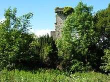
Elphinstone Tower, Falkirk

Elphinstone Tower, also known as Dunmore Tower or Airth Tower, is a ruined tower house on the Dunmore Estate in central Scotland. It is located 1.5 kilometres (0.93 mi) north-west of Airth and 9 kilometres (5.6 mi) east of Stirling in the Falkirk council area. The 16th-century ruin is protected as a category C(S) listed building.[1]
History
The tower dates to the early 16th century, when it was built by Sir John Elphinstone as the seat of the barony of Elphinstone.[2] The Elphinstone Estate was purchased for £16,000 by John Murray, son of the 3rd Earl of Dunmore, in 1754.[3] Two years later he inherited the earldom, and renamed the estate Dunmore after his title. Lord Dunmore built the famous Dunmore Pineapple elsewhere on the estate in 1761. The tower was extended at some point, although there is little evidence that it was occupied.[3] In the 1820s the 5th Earl commissioned the building of Dunmore Park as the principal residence on the estate. The additions to the tower were demolished to allow construction of St Andrew's Episcopal Church, a private chapel completed around 1850.[4] The tower was subsequently restored and the ground floor remodelled as a family burial vault.[2]
The Murray family left Dunmore in 1911, and the tower has since decayed. St Andrew's Church was demolished in the early 1960s,[4] and the north-west angle of the tower collapsed after a storm around 1968.[2] The tower stands 9 by 7.4 metres (30 by 24 ft), and the walls are 17 metres (56 ft) high to the parapet.[2]
See also
- Dunmore, Falkirk, estate village
References
- ↑ "Tower, Dunmore Park: Listed Building Report". Historic Scotland. Retrieved 13 February 2012.
- 1 2 3 4 "Elphinstone Tower". CANMORE. Royal Commission on the Ancient and Historical Monuments of Scotland. Retrieved 13 February 2012.
- 1 2 "Elphinstone or Dunmore Tower". Falkirk Local History Society. Retrieved 13 February 2012.
- 1 2 "St Andrew's Episcopal Church". CANMORE. Royal Commission on the Ancient and Historical Monuments of Scotland. Retrieved 13 February 2012.
| Wikimedia Commons has media related to Elphinstone Tower. |
Coordinates: 56°04′49″N 3°47′06″W / 56.0803°N 3.7850°W