Ellicott's Mills Historic District
|
Ellicott's Mills Historic District | |
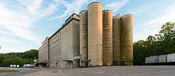
 Wilkins-Rogers Company flour mill | |
  | |
| Nearest city | Oella, Maryland |
|---|---|
| Coordinates | 39°16′5″N 76°47′32″W / 39.26806°N 76.79222°WCoordinates: 39°16′5″N 76°47′32″W / 39.26806°N 76.79222°W |
| Built | 1775 |
| Architect | Ellicott Bros. |
| NRHP Reference # | [1] |
| Added to NRHP | November 19, 1976 |
Ellicott's Mills Historic District is a national historic district at Oella, Baltimore County, Maryland, United States. It is on the east bank of the Patapsco River, opposite Ellicott City. It relates to the industrial operations of the Ellicott family from the 1770s through the mid-19th century. It consists of the sites of historic buildings including: an 18th-century building, a section of an 18th-century mill incorporated in a 20th-century factory, a 19th-century tavern, 19th-century workers housing, and an 1860 villa, united by the major east-west route in Maryland during the early 19th century, the old National Pike. Also in the district is the mammoth multi-story Wilkins-Rogers Company flour plant, which is located on the site of the 1792 Ellicott Flour Mill, the first merchant flour mill in the United States.[2]
It was added to the National Register of Historic Places in 1976.[1]
References
- 1 2 National Park Service (2008-04-15). "National Register Information System". National Register of Historic Places. National Park Service.
- ↑ Maryland Historical Trust: Listing for Ellicott's Mills Historic District
External links
- Ellicott's Mills Historic District, Baltimore County, including photo from 1982, at Maryland Historical Trust
- Boundary Map of the Ellicott's Mills Historic District, Baltimore County, at Maryland Historical Trust
New Discovery of Ellicott's Mills, MD: .03ct Columbia Turnpike Company, Dec. 3rd, 1815, Ellicott's L. Mills, fractional currency note. Signed by; Sam'l Godfory, President. "This bill will be received at the gates, or office, of the Columbia Turnpike Company". pbsphilatelics@mindspring.com for pic's

