Elephant Island
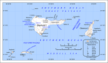
 Map of Elephant Island, Antarctica | |
 Elephant Location in Antarctica | |
| Geography | |
|---|---|
| Location | Antarctica |
| Coordinates | 61°08′S 55°07′W / 61.133°S 55.117°WCoordinates: 61°08′S 55°07′W / 61.133°S 55.117°W |
| Archipelago | South Shetland Islands |
| Area | 558 km2 (215 sq mi) |
| Length | 47 km (29.2 mi) |
| Width | 27 km (16.8 mi) |
| Highest elevation | 853 m (2,799 ft) |
| Highest point | Pardo Ridge |
| Administration | |
| Administered under the Antarctic Treaty | |
| Demographics | |
| Population | Uninhabited |
Elephant Island is an ice-covered mountainous island off the coast of Antarctica in the outer reaches of the South Shetland Islands, in the Southern Ocean. Its name was given by early explorers sighting elephant seals on its shores. The island is situated 245 kilometres (152 miles) north-northeast of the tip of the Antarctic Peninsula, 1,253 kilometres (779 miles) westsouthwest of South Georgia, 935 kilometres (581 miles) south of the Falkland Islands, and 885 kilometres (550 miles) southeast of Cape Horn. It is within the Antarctic claims of Argentina, Chile and the UK. Brazil has a shelter on the island, Goeldi, supporting the work of up to six researchers each during the summer.[1] and another (Wiltgen), which was dismantled in the summer of 1997/98.
Geography

The island is oriented approximately east-west, with a maximum elevation of 853 m (2,799 ft) at Pardo Ridge. Significant named features are Cape Yelcho, Cape Valentine and Cape Lookout at the northeastern and southern extremes, and Point Wild, a spit on the north coast. The Endurance Glacier is the main discharge glacier. Due to slow recoveries and illegal whaling by Soviet Union with support from Japan, numbers of southern right whales visiting Elephant island are still on low level.[2]

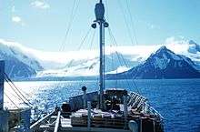
The island supports no significant flora or native fauna although migratory gentoo penguins and seals may be found, and chinstrap penguins nest in season. A lack of safe anchorage has prevented any permanent human settlement, despite the island being well placed to support scientific, fishing and whaling activities.
Elephant Island's name can be attributed to both its elephant head-like appearance and the sighting of elephant seals by Captain George Powell in 1821, one of the earliest sightings. The weather is normally foggy with much snow, and winds can reach 160 km/h (100 mph).
History
First Russian Antarctic expedition
The First Russian Antarctic expedition led by Bellingshausen and Mikhail Lazarev on the 985-ton sloop-of-war Vostok ("East") and the 530-ton support vessel Mirny ("Peaceful") discovered the Island on 29 January 1821 and named it "Остров Мордвинова" (Mordvinov Island) in honour of Admiral Mordvinov. Later this year the expedition discovered Antarctica.
Endurance expedition


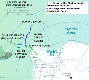
The island is most famous as the desolate refuge of British explorer Ernest Shackleton and his crew in 1916. Following the loss of their ship Endurance in Weddell Sea ice, the 28 exhausted men reached Cape Valentine on Elephant Island after a harrowing ordeal on drifting ice floes. The first of Shackleton's crew to set foot here, and presumably the first person ever to make landfall, was Perce Blackborow, originally a stowaway on Endurance. Since Blackborow was the youngest crew member, Shackleton commanded that he make the first landfall on the island.[3] After camping at Cape Valentine for two nights, Shackleton and his crew moved 11 kilometres (7 mi) westwards to a location which offered better protection from rockfalls and from the sea, and which they called Point Wild.
Realizing that there was no chance of rescue, Shackleton decided to sail to South Georgia where he knew there were several whaling stations. Shackleton sailed with five other men on a 1,287 km (800 mi) voyage in the open lifeboat James Caird on Easter Monday, April 24, 1916, arriving at South Georgia 16 days later. His second-in-command, Frank Wild, was left in charge of the men on Elephant Island, waiting for Shackleton's return with a rescue ship.[4]
There was much work for the stranded men. Because the island had no natural source of shelter, they constructed a shack and wind blocks from their remaining two lifeboats and pieces of canvas tents. Blubber lamps were used for lighting. Expedition physicist Reginald James composed the following verses out of gratitude for Wild's leadership:[5][6]
My name is Frankie Wild-o.
Me hut's on Elephant Isle.
The wall's without a single brick
And the roof's without a tile.
Nevertheless I must confess,
By many and many a mile,
It's the most palatial dwelling place
You'll find on Elephant Isle.
They hunted for penguins and seals, neither of which were plentiful in autumn or winter. Many of the crew were already ill and frostbitten, and they were now also in danger of starvation. After four and a half months, one of the men spotted a ship on August 30, 1916. The ship, with Shackleton on board, was the tug Yelcho, from Punta Arenas, Chile, commanded by Luis Pardo, which rescued all the men who had set out on the original expedition. It was the fourth attempt to rescue the men. The first three attempts were turned back due to a heavy ice pack surrounding the island.
According to Frank Worsley, Shackleton's captain, the men pronounced the island's name with an 'H' prefixed and a silent 't', "Hell-of-an-Island".[7]
Joint Services Elephant Island Expeditions 1970/71
A Joint Services Expedition led by Commander Malcolm Burley was dropped off on Elephant Island by HMS Endurance. The party then spent six months carrying out a survey of the island and other scientific research for the British Antarctic Survey and climbing some of the peaks on the island.[8] The expedition visited Point Wild but found no trace of the Endurance expedition; it found the wreckage of the large sailing vessel referred to below, and also landed on and attempted to climb the highest peak on Clarence Island.
Historic sites
Point Wild contains the Endurance Memorial Site, an Antarctic Historic Site (HSM 53), with a bust of Captain Pardo and several plaques. Hampson Cove on the south-west coast of the island, including the foreshore and intertidal area, contains the wreckage of a large wooden sailing vessel; it has been designated a Historic Site or Monument (HSM 74), following a proposal by the United Kingdom to the Antarctic Treaty Consultative Meeting.[9]
Maps
- British Antarctic Territory. Scale 1:200000 topographic map. DOS 610 Series, Sheet W 61 54. Directorate of Overseas Surveys, Tolworth, UK, 1972.
- South Shetland Islands: Elephant, Clarence and Gibbs Islands. Scale 1:220000 topographic map. UK Antarctic Place-names Committee, 2009.
- Antarctic Digital Database (ADD). Scale 1:250000 topographic map of Antarctica. Scientific Committee on Antarctic Research (SCAR). Since 1993, regularly upgraded and updated.
See also
- Composite Gazetteer of Antarctica
- List of Antarctic and subantarctic islands
- List of Antarctic islands south of 60° S
- SCAR
- Territorial claims in Antarctica
- The Cornet
References
- ↑ "The Brazilian Antarctic Program". Vivabrazil.com. 1984-02-06. Retrieved 2011-04-22.
- ↑ https://www.youtube.com/watch?v=xnDVAMQ2lJQ
- ↑ Shackleton, Earnest South. The Endurance Expedition Penguin Books, London, 1999, p157
- ↑ "Endurance: Shackleton's Legendary Antarctic Expedition". Amnh.org. Retrieved 2011-04-22.
- ↑ Sweet, Leonard, Summoned to Lead, Zondervan, 2004.
- ↑ Obituary of Leonard Hussey
- ↑ Worsley, Frank, Shackleton's Boat Journey, 1933, W.W. Norton & Co., 1998, p. 34?
- ↑ Joint Services Expedition to Elephant Island by M Burley Geographical Journal 1972 http://www.jstor.org/stable/1795437?seq=1#page_scan_tab_contents
- ↑ "List of Historic Sites and Monuments approved by the ATCM (2012)" (PDF). Antarctic Treaty Secretariat. 2012. Retrieved 2014-01-06.
Bibliography
| Wikimedia Commons has media related to Elephant Island. |
- Antarctica Sydney: Reader's Digest, 1985.
- Child, Jack Antarctica and South American Geopolitics: Frozen Lebensraum New York: Praeger Publishers, 1988.
- Furse, Chris Elephant Island - An Antarctic Expedition Shrewsbury: Anthony Nelson Ltd, 7 St John's Hill, Shrewsbury SY1 1JE, England, ISBN 0-904614-02-6.
- Mericq, Luis Antarctica: Chile's Claim. Washington: National Defense University, 1987.
- Pinochet de la Barra, Oscar La Antarctica Chilena Santiago: Editorial Andrés Bello, 1976.
- Stewart, Andrew Antarctica: An Encyclopedia London: McFarland and Co., 1990 (2 volumes).
- Worsley, Frank Shackleton's Boat Journey W.W. Norton & Co., 1933.
