East Toowoomba, Queensland
| East Toowoomba Toowoomba, Queensland | |||||||||||||||
|---|---|---|---|---|---|---|---|---|---|---|---|---|---|---|---|
 | |||||||||||||||
 East Toowoomba | |||||||||||||||
| Coordinates | 27°33′43″S 151°58′8″E / 27.56194°S 151.96889°ECoordinates: 27°33′43″S 151°58′8″E / 27.56194°S 151.96889°E | ||||||||||||||
| Population | 5,676 (2011 census)[1] | ||||||||||||||
| • Density | 1,351/km2 (3,500/sq mi) | ||||||||||||||
| Postcode(s) | 4350 | ||||||||||||||
| Area | 4.2 km2 (1.6 sq mi) | ||||||||||||||
| Location | 2 km (1 mi) E of Toowoomba | ||||||||||||||
| LGA(s) | Toowoomba Region | ||||||||||||||
| State electorate(s) | Toowoomba North | ||||||||||||||
| Federal Division(s) | Groom | ||||||||||||||
| |||||||||||||||
East Toowoomba is a locality in the Toowoomba Region, Queensland, Australia.[2] At the 2011 Australian Census East Toowoomba recorded a population of 5,675.[1]
Geography
East Toowomba is2 kilometres (1 mi) from the Toowoomba central business district. The east and south of the suburb is crossed by the Warrego Highway.
Education

The suburb contains the main Bridge Street campus of Southern Queensland Institute of TAFE, and two elite independent schools, Toowoomba Grammar School (boys) and Fairholme College (girls).
In addition, the suburb contains Toowoomba Preparatory School, Toowoomba East State School (1887) and Mater Dei Primary School (Catholic, 1917).
Toowoomba East State School is Toowoomba's largest primary school with 950 students attending.
Facilities
- Clive Berghofer Stadium, previously known as Athletic Oval and named for former Toowoomba mayor Clive Berghofer (1982–1992), and primarily used for rugby league games;
- St Vincent's Hospital, a private hospital established in 1922 by the Sisters of Charity;[3]
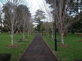
- Queens Park and Botanical Gardens, a heritage-listed reserve established in 1869.[4]
Heritage listings
There are a number of heritage-listed sites in East Toowoomba, including:
- 80 Campbell Street: Whyembah[5]
- 4-6 Fernside Street: Fernside[6]
- 43-79 Lindsay Street: Queens Park[7]
- 24-60 Margaret Street: Toowoomba Grammar School[8]
- 73 Margaret Street: Bishop's House[9]
- 90 Margaret Street: Old Toowoomba Court House[10]
- 124 Margaret Street: Toowoomba Technical College[11]
- 112 Mary Street: Gowrie House[12]
- 9 Phillip Street: Millbrook[13]
- 9-13 Tourist Road: Unara[14]
References
- 1 2 Australian Bureau of Statistics (31 October 2012). "East Toowoomba (State Suburb)". 2011 Census QuickStats. Retrieved 9 November 2014.

- ↑ "East Toowoomba - locality (entry 47935)". Queensland Place Names. Queensland Government. Retrieved 27 June 2017.
- ↑ "St Vincent's Private Hospital Toowoomba". Retrieved 13 July 2013.
- ↑ "Toowoomba Queens Park and Botanic Gardens (entry 601607)". Queensland Heritage Register. Queensland Heritage Council. Retrieved 4 June 2011.
- ↑ "Whyembah (entry 600841)". Queensland Heritage Register. Queensland Heritage Council. Retrieved 15 July 2013.
- ↑ "Fernside (entry 600843)". Queensland Heritage Register. Queensland Heritage Council. Retrieved 15 July 2013.
- ↑ "Toowoomba Queens Park and Botanic Gardens (entry 601607)". Queensland Heritage Register. Queensland Heritage Council. Retrieved 15 July 2013.
- ↑ "Toowoomba Grammar School (entry 600850)". Queensland Heritage Register. Queensland Heritage Council. Retrieved 15 July 2013.
- ↑ "Bishop's House (entry 600845)". Queensland Heritage Register. Queensland Heritage Council. Retrieved 15 July 2013.
- ↑ "Toowoomba Court House & Old Toowoomba Gaol Wall (former) (entry 601315)". Queensland Heritage Register. Queensland Heritage Council. Retrieved 15 July 2013.
- ↑ "Toowoomba Technical College (former) (entry 600851)". Queensland Heritage Register. Queensland Heritage Council. Retrieved 15 July 2013.
- ↑ "Gowrie House (entry 601307)". Queensland Heritage Register. Queensland Heritage Council. Retrieved 15 July 2013.
- ↑ "Millbrook (entry 601310)". Queensland Heritage Register. Queensland Heritage Council. Retrieved 15 July 2013.
- ↑ "Unara (entry 602177)". Queensland Heritage Register. Queensland Heritage Council. Retrieved 15 July 2013.