East Liverpool, Ohio
| East Liverpool, Ohio | |
|---|---|
| City | |
|
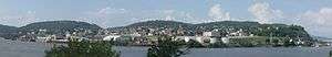
East Liverpool area (including nearby Chester, West Virginia), looking south. | |
| Nickname(s): The Pottery Capital of the World | |
| Motto: "City Of Action" | |
 Location of East Liverpool, Ohio | |
 Location of East Liverpool in Columbiana County | |
| Coordinates: 40°37′43″N 80°34′9″W / 40.62861°N 80.56917°WCoordinates: 40°37′43″N 80°34′9″W / 40.62861°N 80.56917°W | |
| Country | United States |
| State | Ohio |
| County | Columbiana |
| Government | |
| • Mayor | Ryan Stovall |
| Area[1] | |
| • Total | 4.76 sq mi (12.33 km2) |
| • Land | 4.56 sq mi (11.81 km2) |
| • Water | 0.20 sq mi (0.52 km2) |
| Elevation[2] | 768 ft (234 m) |
| Population (2010)[3] | |
| • Total | 11,195 |
| • Estimate (2015[4]) | 10,846 |
| • Density | 2,455.0/sq mi (947.9/km2) |
| Time zone | Eastern (EST) (UTC−5) |
| • Summer (DST) | EDT (UTC−4) |
| ZIP code | 43920 |
| Area code | 330, 234 |
| FIPS code | 39-23730[5] |
| GNIS feature ID | 1061038[2] |
| Website | http://www.eastliverpool.com/ |
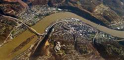
East Liverpool is a city in Columbiana County, Ohio, United States. The population was 11,195 at the time of the 2010 census. It is located along the Ohio River and borders the states of Pennsylvania and West Virginia. East Liverpool is a major city in the Salem, OH Micropolitan Statistical Area, approximately 40 miles from downtown Pittsburgh.
Historically, it was referred to as the "Pottery Capital of the World" due to the large number of potteries in the city;[6][7] due to changes in the industry, only three remain in the area. The city is also known as the hometown of former University of Notre Dame and University of South Carolina football coach Lou Holtz. It was the destination for the body of bank robber Pretty Boy Floyd, taken there for embalming. The Beginning Point of the U.S. Public Land Survey is just east of the city center, on the Ohio–Pennsylvania border.
History
East Liverpool traces its European-American settlement to 1798 when Thomas Fawcett purchased 1,100 acres of land along the Ohio River in what was then Jefferson County. In 1802 he platted the town of St. Clair, named for Arthur St. Clair, who at that time was Governor of the Northwest Territory.[8] It was called Fawcettstown for a time by the residents. In 1816, they changed the name to Liverpool. It was incorporated as East Liverpool in 1834 when Liverpool Township in Medina County objected to possible confusion.

James Bennett, an English potter, established the pottery industry in East Liverpool, and it became the community's leading employer. East Liverpool became known as "The Crockery City." From 1870 through 1890, the US Census showed that the city more than doubled in population each decade, as it attracted new industrial workers with the growth of the pottery industry. By 1910, it had more than 20,000 people. East Liverpool once produced more than half of the United States's annual ceramics output. Throughout East Liverpool's ceramics history, there were more than 300 potteries.
Of these potteries, three continue to operate in this area: The Hall China Company, the Homer Laughlin China Company (located across the Ohio River in Newell, West Virginia), and Pioneer Pottery. In the mid-19th century, East Liverpool also produced most of the yellowware pottery used in the United States. Among the most famous of East Liverpool's ceramics was the porcelain known as Lotus Ware. Produced by Knowles, Taylor & Knowles in the 1890s, this Moorish- and Persian-influenced artware swept the competition at the 1893 World's Fair in Chicago. It is generally considered to be the finest porcelain ever produced in the US. The Museum of Ceramics in downtown East Liverpool has the world's largest public display of Lotus Ware.
As of 1914, East Liverpool was served by the Cleveland and Pittsburgh Railroad.[9]
The city reached its peak population of more than 26,000 in 1970, but East Liverpool's pottery industry had already begun its decline by the mid-1960s or so. As with other industries, production moved to developing countries where labor costs were cheaper. This cost many jobs and, ultimately, population in the Ohio/West Virginia area, as people moved away in search of work.
In the mid-1990s, the city renovated its downtown district. To improve its urban design, it installed Great Depression-era lightposts, developed a new center called Devon's Diamond, and reconstructed the old high school's clocktower. This building is now the home of the East Liverpool High School Alumni Association.
Areas and neighborhoods
- Downtown – East Liverpool's centralized business district, located on the "flats" in the river valley. Downtown is considered to lie between Ohio State Routes 7/11/39/U.S. Route 30 in the west, College and Walnut streets in the east, West 2nd Street in the South, and Moore and Grant streets in the North. The heart of the business center during the first half of the nineteenth century was located between the Ohio River and 3rd Street. However, during the second half of the century, as East Liverpool attracted more industry and the population grew, the center of business moved north between 4th and 6th Streets. Business remained near the river until the regional economic depression beginning in the 1960s. a freeway was constructed between the river and downtown, leading to demolition of much of the original business center between 2nd and 3rd Streets. Only a few residents, a few small industries, and the Broadway Wharf remain near 2nd Street and the river, both now geographically separated from Downtown by the highway.
- West End – The western end of the city is located between the Ohio State Routes 7/11/39/U.S. Route 30 freeway in the east, Shadyside Road in the west, Riverside Park in the south and Hazel Street in the north. Until the freeway project in the 1960s and '70s, the West End was "connected" to Downtown. However, like the riverfront area of Downtown, it is now geographically isolated on the other side of the freeway. It is home to Westgate Middle School and Patterson Field, the city's football stadium. The West End has two distinct small neighborhoods:
- Sunnyside – Between Lisbon and West 9th streets to the south and Hazel Street in the north.
- Jethro – South of West 8th Street, between Gaston Avenue in the east and Edwards Street in the west. Before the rapid growth of the city in the second half of the nineteenth century, Jethro was a separate village. It was later incorporated into the city. Residents used to live in the low-lying area to its west known as Jethro Hollow, but most have since moved out due to flood risks from the river.
- East End – The East End is within the city limits, but it is almost entirely isolated from the rest of East Liverpool, connected only by River Road and the Route 11/39 freeway. East End is considered to be all of the flats between St. George and State streets in the west and the border with Pennsylvania in the east. Similar to Jethro in the West End, East End originated as a few separate satellite communities that were absorbed in the nineteenth century by the growing city .
- Pleasant Heights – A neighborhood situated on top of a plateau above the West End to the south and the freeway to the east, Pleasant Heights surrounds Lisbon Street (Ohio State Route 267). Its southernmost point is the dead end of Oakwood Street, and it extends north to Myler Road. Pleasant Heights was one of the several neighborhoods developed during East Liverpool's expansion "up the hill" in the late nineteenth and early twentieth centuries.
- Fisher Park – A self-contained neighborhood, all between South and North Shadylane drives on the east side of Lisbon Street. Named for the Fisher Farm located in the area, the farm house can still be found along Lisbon Street as a private residence.
- Beechwood – The neighborhood situated below Maine Boulevard between Anderson Boulevard and Park Way.
- Thompson – This neighborhood borders the east end of Downtown. It extends east from College and Walnut streets and goes "up the hill" above the freeway. Its northern end is Morton and Bank streets, and extends to the edge of the hill at Thompson Avenue and Vine Street.
Satellite communities
Though not located within the city limits, there are a few communities that share East Liverpool's 43920 ZIP code and have an East Liverpool mailing address. They are the census-designated places of Calcutta, Glenmoor and La Croft and the unincorporated community of Fredericktown.
Neighboring communities
In the bordering states of West Virginia and Pennsylvania, the communities of Chester and Newell, West Virginia and Glasgow, Pennsylvania developed and grew in relation to the growth of the pottery industry and expansion of East Liverpool in the late nineteenth and early twentieth centuries.
Calcutta, Glenmoor, La Croft, & Fredericktown, Ohio; Chester & Newell, West Virginia; and Glasgow & Georgetown, Pennsylvania are all generally considered the East Liverpool area, although they fall into different metropolitan areas (Ohio portions are considered part of the Salem, OH Micropolitan Statistical Area; West Virginia portions are considered part of the Weirton-Steubenville, WV-OH Metropolitan Statistical Area; and Pennsylvania portions fall into the Pittsburgh, PA Metropolitan Statistical Area).
Education
Primary and secondary
Children in East Liverpool (and immediate surrounding areas in Liverpool Township) are served by the East Liverpool City School District. The current schools in the district are:
- La Croft Elementary School – 2460 Boring Lane (located immediately outside the city limits in La Croft), grades K-4
- North Elementary School – 100 Maine Boulevard, grades K-4
- Westgate Middle School – 810 West 8th Street, grades 5-6
- East Liverpool Junior/Senior High School – 100 Maine Boulevard, grades 7-12
The East Liverpool Christian School also serves grades K-12 as the primary area private school option. In addition, an online school, Buckeye Online School for Success, operates out of downtown.
St. Aloysius School (K-8) formerly operated for 130 years as a Roman Catholic School in the Diocese of Youngstown, before closing on June 6, 2015.
Postsecondary
Kent State University has been operating a satellite campus, Kent State University at East Liverpool, since 1965. It is clustered around 4th Street in Downtown. The Ohio Valley College of Technology in nearby Calcutta also focuses on job training.
Transportation
Highways
Airports
The Columbiana County Airport is located four miles northwest of the city.
Bridges
Since the 1890s, East Liverpool and the West Virginia communities of Chester and Newell have been connected by three different bridges spanning the Ohio River.
- Chester Bridge (1896–1969) – Connected College Street in East Liverpool with 1st Street in Chester. It was the original bridge to carry U.S. Route 30. The bridge closed on May 14, 1969, and was demolished in 1970.[10]
- Newell Bridge (1905–present) – Connects West 5th Street near East Liverpool City Hospital with West Virginia State Route 2. It is the only privately owned toll bridge on the Ohio River, owned and operated by the Homer Laughlin China Company out of Newell.[11]
- Jennings Randolph Bridge (1977–present) – Replaced the demolished Chester Bridge in the 1970s as the span connecting East Liverpool and Chester, and carrying Route 30 over the river. Named for West Virginia congressman/senator Jennings Randolph (in office 1933-1947 and 1958-1985, respectively).[11]
Recreation
Golf course
The East Liverpool Country Club has a 9-hole golf course that was designed by Willie Park, Jr. and opened on July 14, 1921. Calcutta also features the 18-hole Turkana Golf Course.
Parks
There are two public parks located within East Liverpool city limits.
- Thompson Park – After Will Lamartine Thompson donated 100 acres of land to the city of East Liverpool in 1899,[12] Thompson Park opened in 1900 as a green space to get away from the industry of the city.[11] It has been open ever since, and amenities include picnic pavilions, a swimming pool, a football field, a baseball field, a disc golf course, a playground and walking trails. The main entrance to Thompson Park is located on Park Way at the end of Park Boulevard. There is also a back entrance on Anderson Boulevard.
- Broadway Wharf – A small public park/boat launch near the Ohio River. Located near the ends of Broadway, East 2nd Street and River Road.
Additionally, Beaver Creek State Park is located outside the city limits but partially within the 43920 ZIP code area.
Athletics
Because of its size, East Liverpool has never had a major professional sports team. However, during the city's heyday, many semipro and company teams, and city and area leagues were thriving. Baseball, basketball and American football were all popular among residents, and games attracted many patrons. The semipro East Liverpool Potters basketball team of the Central Basketball League played in the city from 1906 to 1909. No semipro or company teams exist in the city today.
East Liverpool High School athletics have been consistently popular among students and residents in the past 100-plus years. All of the teams are known as the Potters. The school fields American football, baseball, basketball, bowling, cross country running, golf, soccer, softball, swimming, tennis, track and field, volleyball and wrestling teams. Most of these teams have had team and/or individual successes in their existences. Athletic facilities include:
- Patterson Field – football stadium, opened 1924 (current concrete bleachers constructed in 1934). Located near East Liverpool Middle School at 810 West 8th Street.
- Potter Fieldhouse – home of Potters basketball, volleyball and wrestling. Located next to East Liverpool High School at 100 Maine Boulevard.
- ELHS Baseball Field – located between the high school and Trinity Presbyterian Church on Maine Boulevard.
Media
- East Liverpool was once home to several newspapers, but only The Review survives, serving chiefly southern Columbiana County, Ohio and northern Hancock County, West Virginia.
- The AM radio station WOHI has broadcast from the city since December 1, 1949. The city also had a station on the FM dial 104.3, WOGI, formerly known as WELA, but its city of license was moved to Moon Township, Pennsylvania and now serves the Pittsburgh radio market
- Though East Liverpool has never had a local television station of its own, the area receives stations from Pittsburgh, Youngstown and Steubenville. These stations include KDKA-TV, WTAE-TV, WYTV, WFMJ-TV, WTOV-TV, WKBN-TV, WPXI, WPGH-TV, WQED-TV and WNEO.
Geography
East Liverpool is located at 40°37′43″N 80°34′9″W / 40.62861°N 80.56917°W (40.628510, -80.569063).[13] It lies within the ecoregion of the Western Allegheny Plateau.[14]
According to the United States Census Bureau, the city has a total area of 4.76 square miles (12.33 km2), of which 4.56 square miles (11.81 km2) is land and 0.20 square miles (0.52 km2) is water.[1]
Demographics
| Historical population | |||
|---|---|---|---|
| Census | Pop. | %± | |
| 1830 | 136 | — | |
| 1840 | 503 | 269.9% | |
| 1850 | 987 | 96.2% | |
| 1860 | 1,308 | 32.5% | |
| 1870 | 2,105 | 60.9% | |
| 1880 | 5,568 | 164.5% | |
| 1890 | 10,956 | 96.8% | |
| 1900 | 16,485 | 50.5% | |
| 1910 | 20,387 | 23.7% | |
| 1920 | 21,411 | 5.0% | |
| 1930 | 23,329 | 9.0% | |
| 1940 | 23,555 | 1.0% | |
| 1950 | 24,217 | 2.8% | |
| 1960 | 22,306 | −7.9% | |
| 1970 | 26,243 | 17.6% | |
| 1980 | 16,517 | −37.1% | |
| 1990 | 13,654 | −17.3% | |
| 2000 | 13,089 | −4.1% | |
| 2010 | 11,195 | −14.5% | |
| Est. 2016 | 10,743 | [15] | −4.0% |
| Sources:[5][16][17][18] | |||
2010 census
As of the census[3] of 2010, there were 11,195 people, 4,601 households, and 2,892 families residing in the city. The population density was 2,455.0 inhabitants per square mile (947.9/km2). There were 5,316 housing units at an average density of 1,165.8 per square mile (450.1/km2). The racial makeup of the city was 91.7% White, 4.6% African American, 0.2% Native American, 0.2% Asian, 0.3% from other races, and 3.0% from two or more races. Hispanic or Latino of any race were 1.1% of the population.
There were 4,601 households of which 33.4% had children under the age of 18 living with them, 36.0% were married couples living together, 20.1% had a female householder with no husband present, 6.7% had a male householder with no wife present, and 37.1% were non-families. 31.9% of all households were made up of individuals and 11.9% had someone living alone who was 65 years of age or older. The average household size was 2.39 and the average family size was 2.97.
The median age in the city was 37.6 years. 25.4% of residents were under the age of 18; 9.5% were between the ages of 18 and 24; 24% were from 25 to 44; 26.5% were from 45 to 64; and 14.6% were 65 years of age or older. The gender makeup of the city was 47.6% male and 52.4% female.
2000 census
As of the census[5] of 2000, there were 13,089 people, 5,261 households, and 3,424 families residing in the city. The population density was 3,010.3 people per square mile (1,161.8/km²). There were 5,743 housing units at an average density of 1,320.8 per square mile (509.7/km²). The racial makeup of the city was 92.85% White, 4.81% African American, 0.24% Native American, 0.08% Asian, 0.05% Pacific Islander, 0.21% from other races, and 1.76% from two or more races. Hispanic or Latino of any race were 0.72% of the population.
There were 5,261 households out of which 32.9% had children under the age of 18 living with them, 43.5% were married couples living together, 16.6% had a female householder with no husband present, and 34.9% were non-families. 30.3% of all households were made up of individuals and 13.5% had someone living alone who was 65 years of age or older. The average household size was 2.44 and the average family size was 3.01.
In the city the population was spread out with 27.1% under the age of 18, 8.8% from 18 to 24, 27.3% from 25 to 44, 20.8% from 45 to 64, and 16.0% who were 65 years of age or older. The median age was 36 years. For every 100 females there were 86.5 males. For every 100 females age 18 and over, there were 81.8 males.
The median income for a household in the city was $23,138, and the median income for a family was $27,500. Males had a median income of $27,346 versus $18,990 for females. The per capita income for the city was $12,656. About 21.5% of families and 25.2% of the population were below the poverty line, including 35.2% of those under age 18 and 13.0% of those age 65 or over.
Notable people
- Dan Adkins – comic book artist for Marvel and other companies grew up in East Liverpool
- Bernie Allen – professional baseball player: second baseman for the Minnesota Twins, the Washington Senators, the New York Yankees, and the Montreal Expos
- Dick Booth - professional football player, halfback for the Detroit Lions
- Less Browne – professional football player: defensive back for the Pittsburgh Maulers (USFL), Hamilton Tiger-Cats, Winnipeg Blue Bombers, Ottawa Rough Riders and BC Lions (CFL)
- John Caparulo – stand-up comedian
- Jane Louise Curry – writer for children
- Ben Feldman (1912–1993) – one of the most prolific salespeople in world history
- John Godwin, baseball player
- Lou Holtz – author, television commentator, motivational speaker, and former NCAA football head coach
- George P. Ikirt – physician and U.S. Representative from Ohio
- Bob McFadden- voice actor
- Benedict Charles Franzetta – Catholic bishop
- O. O. McIntyre – feature writer for East Liverpool Morning Tribune before going on to reach 7,000,000 readers daily with his syndicated column
- Hy Myers – major league baseball player, led the National League in RBIs and slugging percentage in 1919 while playing for the Brooklyn Dodgers
- Elaine Riley – actress
- Ruth Crawford Seeger – famous composer and first woman to receive the Guggenheim Fellowship
- Josiah Thompson, author of Six Seconds in Dallas[19]
- Will Lamartine Thompson – composer, best known for his hymns
- Norm Van Lier – star basketball point guard, played at Saint Francis University and in the NBA for the Cincinnati Royals, Chicago Bulls, and Milwaukee Bucks in the 1970s
- Jabez Vodrey – prominent early potter
- Derek Wolfe – graduate of Beaver Local High School, played college football for the University of Cincinnati Bearcats and currently plays professional football for the Denver Broncos.
- Peter Wooley - Hollywood film producer and Emmy Award nominated art director. Production designer for Blazing Saddles. Grandfather of Anthony Angelini. Inducted into the Upper Ohio Valley Hall of Fame in 2016.
- Imagine. Hip Hop Artist and Music Producer. Known for his works with notable Hip Hop Artists such as, Corey Gunz, Young Money, Cassidy,Freeway, French Montana and the Coke Boys.
References
- 1 2 "US Gazetteer files 2010". United States Census Bureau. Archived from the original on 2012-01-24. Retrieved 2013-01-06.
- 1 2 "US Board on Geographic Names". United States Geological Survey. 2007-10-25. Retrieved 2008-01-31.
- 1 2 "American FactFinder". United States Census Bureau. Retrieved 2013-01-06.
- ↑ "Annual Estimates of the Resident Population for Incorporated Places: April 1, 2010 to July 1, 2015". Retrieved 2016-07-02.
- 1 2 3 "American FactFinder". United States Census Bureau. Archived from the original on 2013-09-11. Retrieved 2008-01-31.
- ↑ Museum of Ceramics
- ↑ City of Easter Liverpool Website
- ↑ McCord, William B. (1905). History of Columbiana County, Ohio and Representative Citizens. Biographical Publishing Company. p. 286.
- ↑ Beach, Chandler B. and Frank Morton McMurry, editors (1914). The New Student's Reference Work. Chicago: F.E. Compton and Company. p. 577. Retrieved 31 August 2014.
- ↑
- 1 2 3 Judith A Allison, Webmaster@eastliverpoolhistoricalsociety.org. "ELHistSoc – Memorable East Liverpool Dates". Eastliverpoolhistoricalsociety.org. Retrieved 2013-09-28.
- ↑ Archived March 15, 2012, at the Wayback Machine.
- ↑ "US Gazetteer files: 2010, 2000, and 1990". United States Census Bureau. 2011-02-12. Retrieved 2011-04-23.
- ↑ "Level III Ecoregions of Ohio". National Health and Environmental Effects Research Laboratory. U.S. Environmental Protection Agency. Retrieved 28 September 2013.
- ↑ "Population and Housing Unit Estimates". Retrieved June 9, 2017.
- ↑ "Number of Inhabitants: Ohio" (PDF). 18th Census of the United States. U.S. Census Bureau. Retrieved 22 November 2013.
- ↑ "Ohio: Population and Housing Unit Counts" (PDF). U.S. Census Bureau. Retrieved 22 November 2013.
- ↑ "Incorporated Places and Minor Civil Divisions Datasets: Subcounty Population Estimates: April 1, 2010 to July 1, 2012". U.S. Census Bureau. Archived from the original on 17 June 2013. Retrieved 25 November 2013.
- ↑ Hoover, Bob (December 28, 1991). "Turning the page on JFK". Pittsburgh Post-Gazette. p. 16. Retrieved August 16, 2014.
Further reading
- Adler, Jerry. "It's not easy being green." Newsweek 28 Feb. 1992. EBSCOhost. Web. 17 Apr. 2010.
- Jones, Arthur. "Toxic-waste incinerator in the backyard: White House and church steer clear in Ohio." National Catholic Reporter 18 Feb. 1994: 5+. Academic OneFile. Web. 17 Apr. 2010.
External links
- Official City of East Liverpool website
- East Liverpool Area Chamber of Commerce
- East Liverpool City Schools
Municipalities and communities of Columbiana County, Ohio, United States | ||
|---|---|---|
| Cities |  | |
| Villages | ||
| Townships | ||
| CDPs | ||
| Unincorporated communities |
| |
| Ghost town | ||
| Footnotes | ‡This populated place also has portions in an adjacent county or counties | |