East Korea Bay
| East Korea(n) Bay | |||||||
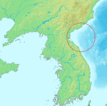
 The location of East Korea Bay. | |||||||
| North Korean name | |||||||
|---|---|---|---|---|---|---|---|
| Chosŏn'gŭl | 동조선만 | ||||||
| Hancha | 東朝鮮灣 | ||||||
| |||||||
| South Korean name | |||||||
| Hangul | 동한만 | ||||||
| Hanja | 東韓灣 | ||||||
| |||||||
East Korea or East Korean Bay, also known by its Korean names Dongjoseon-man or Donghan-man, is a bay in North Korea and an extension of the Sea of Japan (East Sea of Korea). It is located between the provinces of South Hamgyong and Kangwon. Its northern end is Musu Dan, near the Musudan Village missile site which gave its name to North Korea's Taepodong and Musudan missiles.
It was formerly also known in English as Broughton Bay.[1]
See also
- Korean Peninsula
- Korea Bay (West Korea Bay)
References
Citations
Bibliography
- "Corea", Encyclopædia Britannica, 9th ed., Vol. VI, New York: Charles Scribner's Sons, 1878, pp. 390–394.
Coordinates: 39°30′00″N 127°49′59″E / 39.5°N 127.833°E
This article is issued from
Wikipedia.
The text is licensed under Creative Commons - Attribution - Sharealike.
Additional terms may apply for the media files.