Dyjákovice
| Dyjákovice | |||
|---|---|---|---|
| Municipality | |||
 | |||
| |||
 Dyjákovice | |||
| Coordinates: 48°46′22″N 16°18′10″E / 48.77278°N 16.30278°ECoordinates: 48°46′22″N 16°18′10″E / 48.77278°N 16.30278°E | |||
| Country |
| ||
| Region | South Moravian | ||
| District | Znojmo | ||
| Area | |||
| • Total | 19.3 km2 (7.5 sq mi) | ||
| Elevation | 185 m (607 ft) | ||
| Population (1.1.2012) | |||
| • Total | 831 | ||
| • Density | 43/km2 (110/sq mi) | ||
| Postal code | 671 26 | ||
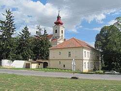
Dyjákovice (German: Groß Tajax) is a village and municipality (obec) in Znojmo District in the South Moravian Region of the Czech Republic.
The municipality covers an area of 19.3 square kilometres (7.5 sq mi), and has a population of 849 (as at 2 October 2006).
Dyjákovice lies approximately 22 kilometres (14 mi) south-east of Znojmo, 53 km (33 mi) south-west of Brno, and 200 km (124 mi) south-east of Prague.
Population development
| Census year | Population | Ethnicity of inhabitants | ||
|---|---|---|---|---|
| year | German | Czechs | other | |
| 1880 | 2545 | 2545 | – | – |
| 1890 | 2611 | 2611 | – | - |
| 1900 | 2758 | 2753 | 3 | 2 |
| 1910 | 2901 | 2895 | 5 | 1 |
| 1921 | 3007 | 2940 | 36 | 31 |
| 1930 | 3257 | 3173 | 54 | 30 |
| 2006 | 849 | |||
Document
- ↑ Historický místopis Moravy a Slezska v letech 1848–1960, sv.9. 1984
References
External links
| Wikimedia Commons has media related to Dyjákovice. |
This article is issued from
Wikipedia.
The text is licensed under Creative Commons - Attribution - Sharealike.
Additional terms may apply for the media files.

