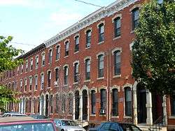
Drexel Development Historic District
|
Drexel Development Historic District | |
 Drexel Development Historic District, May 2010 | |
   | |
| Location | Roughly bounded by Pine, Delancy, 39th and 40th Sts., Philadelphia, Pennsylvania |
|---|---|
| Coordinates | 39°57′3″N 75°12′9″W / 39.95083°N 75.20250°WCoordinates: 39°57′3″N 75°12′9″W / 39.95083°N 75.20250°W |
| Area | 1 acre (0.40 ha) |
| Built | 1870 |
| Architect | Sloan, Samuel; Hewitt, G.W. & W. D. |
| Architectural style | Second Empire, Italianate, Other, High Victorian |
| NRHP Reference # | 82001546[1] |
| Added to NRHP | November 14, 1982 |
Drexel Development Historic District is a national historic district located in the University City neighborhood of Philadelphia, Pennsylvania. It encompasses 96 contributing rowhouses dated to the mid- to late-19th century. A number of the rowhouses were designed by noted architect Samuel Sloan. The architectural firm G. W. & W. D. Hewitt designed rowhouses for developer Anthony Joseph Drexel on the block bounded by Pine, new 39th, Baltimore, and 40th Streets. They are representative of a number of popular architectural styles including Second Empire, Italianate, and High Victorian.[2]
It was added to the National Register of Historic Places in 1982.[1]
References
- 1 2 National Park Service (2010-07-09). "National Register Information System". National Register of Historic Places. National Park Service.
- ↑ "National Historic Landmarks & National Register of Historic Places in Pennsylvania" (Searchable database). CRGIS: Cultural Resources Geographic Information System. Note: This includes Carl E. Doebley (February 1981). "National Register of Historic Places Inventory Nomination Form: Drexel Development Historic District" (PDF). Retrieved 2012-07-18.
This article is issued from
Wikipedia.
The text is licensed under Creative Commons - Attribution - Sharealike.
Additional terms may apply for the media files.

