Dora di Bardonecchia
| Dora di Bardonecchia | |
|---|---|
|
| |
 Location within the upper Susa Valley (NW Italy) | |
| Country | Italy: the Piedmontese communes of Bardonecchia and Oulx in the Upper Val di Susa. |
| Basin features | |
| Main source |
Confluence of various mountain torrents at Bardonecchia 1,250 m (4,100 ft) |
| River mouth | Dora Riparia |
| Basin size | 240.5 km2 (92.9 sq mi)[1] |
| Physical characteristics | |
| Discharge |
|
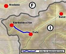
The Dora di Bardonecchia is a short tributary of the Dora Riparia river, lying entirely within the upper Susa Valley in the Metropolitan City of Turin, Piedmont, Italy.
Geography
It originates just outside Bardonecchia from the confluence of mountain streams from the valleys of Rochemolles, Frejus, Rho, and Valle Stretta. It follows the valley for about 20 kilometres (12 mi) and joins the Dora Riparia northeast of Oulx.
Several major road and rail lines run parallel to the river: the A32 motorway from Torino to Bardonecchia; state highway SS535, Strada Statale di Bardonecchia; the international double-track Fréjus railway, the main line of the Rome-Torino-Paris run.
Notes
- 1 2 AA.VV. (2004). "Elaborato I.c/7". Piano di Tutela delle Acque - Revisione del 1º luglio 2004; Caratterizzazione bacini Idrografici (PDF). Regione Piemonte. Retrieved 2014-01-07.
Other projects
![]() Media related to Dora di Bardonecchia at Wikimedia Commons
Media related to Dora di Bardonecchia at Wikimedia Commons
Coordinates: 45°2′41″N 6°50′9″E / 45.04472°N 6.83583°E