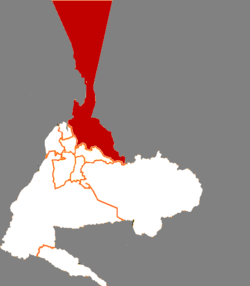
Midong District
| Midong 米东区 • مىچۈەن-كۆكتاغ رايونى | |
|---|---|
| District | |
|
Lucaogou Railway Station | |
 | |
| Country | China |
| Province | Xinjiang |
| Prefecture-level divisions | Ürümqi |
| Time zone | China Standard (UTC+8) |
Midong District (Pinyin: Mǐdōng Qū Uyghur: مىچۈەن-كۆكتاغ رايونى, ULY: Michuan-Köktagh Rayoni, UYY: Miqüen-Kɵktaƣ Rayoni? USY: Мичүән-Көктағ Райони) is a county in the Prefecture-level city of Ürümqi, which is the capital region of China's Xinjiang Uyghur Autonomous Region. Its land area is 3408 km2; it has a population of 296,000.[1]
History
Midong District was formed in 2007 by merging the former Dongshan District of Ürümqi (244 km2, population of 100,000, as per the 2002 Census) with the Miquan (formerly part of Changji Hui Autonomous Prefecture).[2]
Geography
Midong District includes northern and eastern suburbs of Ürümqi, as well as a large slice of the Gurbantünggüt Desert north of the city which is administratively included into Ürümqi.
The natural water sources in the Ürümqi area mostly consist of streams that flow from the snow-capped Tian Shan mountains south of the city. Since Midong District is located north, and therefore downstream, of the main urban area, the water supply problems there are particularly acute. [3] To enable the area's economic development, the Irtysh–Ürümqi Canal was brought to Midong during the first decade of the 20th century. Its main terminal is the so-called "Reservoir 500", constructed at the border of Midong District and Fukang County-level City (44°12′00″N 87°49′00″E / 44.20000°N 87.81667°E).[4]
References
- ↑ http://www.xzqh.org/quhua/65xj/0108md.htm
- ↑ http://www.xzqh.org/quhua/65xj/0108md.htm
- ↑ 解决米东新区建设项目供水紧缺问题的方向, (Approaches to solving water supply problems for the development projects in the Midong New Area) 2009-01-13
- ↑ 高新区(新市区)甘泉堡工业园基本概况--乌鲁木齐高新技术产业开发区(新市区) (High-tech zone Ganquanbao Industrial Park Facts - Urumqi High-tech Industrial Development Zone (new city)) (in Chinese), 2012-05-21
Coordinates: 43°48′N 87°35′E / 43.800°N 87.583°E
