Dobřív
| Dobřív | |||
|---|---|---|---|
| Municipality | |||
 | |||
| |||
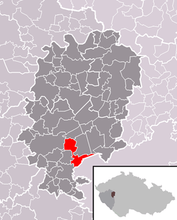 Location in Rokycany District | |||
 Dobřív Location in the Czech Republic | |||
| Coordinates: 49°42′56″N 13°41′13″E / 49.71556°N 13.68694°ECoordinates: 49°42′56″N 13°41′13″E / 49.71556°N 13.68694°E | |||
| Country |
| ||
| Region | Plzeň | ||
| District | Rokycany | ||
| Area | |||
| • Total | 12.14 km2 (4.69 sq mi) | ||
| Elevation | 417 m (1,368 ft) | ||
| Population (1.1.2015) | |||
| • Total | 1,286 | ||
| • Density | 110/km2 (270/sq mi) | ||
| Postal code | 338 44 | ||
| Website | https://web.archive.org/web/20100201175352/http://www.dobriv.rokycansko.cz:80/ | ||
Dobřív is a village and municipality (obec) in Rokycany District in the Plzeň Region of the Czech Republic.
The municipality covers an area of 12.14 square kilometres (4.69 sq mi), and has a population of 1,179 (as at 2 October 2006).
Dobřív lies approximately 9 kilometres (6 mi) south-east of Rokycany, 23 km (14 mi) east of Plzeň, and 67 km (42 mi) south-west of Prague.
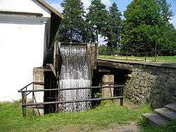
The village is known throughout the Czech Republic for its very rare example of a fully functioning water powered forge. Its precise age is unknown, although the earliest record of its existence dates back to 1505.
References
The village is known throughout the Czech Republic for its very rare example of a fully functioning water powered forge. Its precise age is unknown, although the earliest record of its existence dates back to 1505.
| Wikimedia Commons has media related to Dobřív. |