DeFuniak Springs, Florida
| DeFuniak Springs, Florida | |
|---|---|
| City | |
|
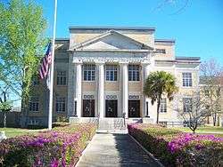
Walton County Courthouse | |
| Nickname(s): "Partnership' Planning' And Preservation " | |
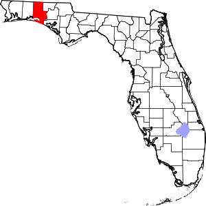
 Location in Walton County and the state of Florida | |
| Coordinates: 30°43′N 86°7′W / 30.717°N 86.117°WCoordinates: 30°43′N 86°7′W / 30.717°N 86.117°W | |
| Country |
|
| State |
|
| County | Walton |
| Area[1] | |
| • Total | 14.26 sq mi (36.93 km2) |
| • Land | 13.84 sq mi (35.83 km2) |
| • Water | 0.42 sq mi (1.10 km2) |
| Elevation | 259 ft (79 m) |
| Population (2010) | |
| • Total | 5,177 |
| • Estimate (2016)[2] | 6,284 |
| • Density | 454.21/sq mi (175.37/km2) |
| Time zone | Central (CST) (UTC-6) |
| • Summer (DST) | CDT (UTC-5) |
| ZIP codes | 32433, 32435 |
| Area code(s) | 850 Exchanges: 892,951 |
| FIPS code | 12-16800[3] |
| GNIS feature ID | 0294592[4] |
| Website | http://www.defuniaksprings.net |
DeFuniak Springs is a city in Walton County, Florida, United States. The population was 5,089 at the 2000 census. It is the county seat of Walton County.
History
The town was founded by the officers of the Pensacola and Atlantic Railroad, a subsidiary of the Louisville and Nashville Railroad. The P&A was organized to connect the terminus of the L&N at Pensacola to the western terminus of a predecessor of the Seaboard Air Line Railroad at River Junction—now Chattahoochee—in the 1880s. It was named after Frederick R. De Funiak,[5] a vice-president of the L&N. Like much of Northwest Florida, DeFuniak Springs was settled mainly by Scots from Virginia and the Carolinas.
DeFuniak Springs was established as a final-destination resort, and the developers enlisted the cooperation and aid of the Chautauqua Movement. The Chautauqua Hall of Brotherhood, an auditorium seating 4,000, was constructed on Lake DeFuniak in the center of town. Seminars, classes, and the like were held in the Hall of Brotherhood building for people on vacation. The auditorium of the building was severely damaged by Hurricane Eloise in 1975 and razed. However, a charitable foundation, The Chautauqua Hall of Brotherhood Foundation, Inc., has undertaken a capital campaign for the historic restoration of the building.[6] The westerly portion of the building facing Circle Drive is still in use.
As part of the intellectual atmosphere of the town, a college and a private high school (named Palmer College and Palmer Academy, respectively), as well as a technical school (Thomas Industrial Institute) and a teacher training school (Florida Normal College) were established in the 19th century. Florida Normal College was later incorporated into Florida State University, while the other schools closed during the Great Depression. There remains a College Avenue that once led to Palmer College.
As demonstrated through the Chautauqua movement, many residents of DeFuniak Springs have always had an active hand in education. In 1886, the town held an important meeting that forever changed the course of public education in Florida. At this meeting, teachers from around the state formed the Florida Education Association. This teachers' union remains the state's predominant voice for educators and is affiliated with the National Education Association and the American Federation of Teachers.
The town also contains various other historically significant landmarks. Near the Chautauqua Hall of Brotherhood building is the Walton County Library on Circle Drive, the oldest extant library in the state of Florida.[7] The library contains an interesting assortment of antiquities, including an impressive medieval weapon collection and many first-edition books. First Presbyterian Church is the only private structure in the Lake Yard, the park surrounding the lake. Also situated on Circle Drive are the Walton County Heritage Museum, housed in the former L&N railroad depot, and St. Agatha's Episcopal Church, built in 1895-1896. Although Walton County was opposed to secession, the first monument to the Confederate war dead constructed in Florida is located on the lawn of the Walton County Courthouse.
A chicken processing plant operated by Perdue Farms at DeFuniak Springs was closed in April 2004.[8]
Geography
DeFuniak Springs is located at 30°43'N 86°7'W (30.721,-86.119).[9]
According to the United States Census Bureau, the city has a total area of 11.2 square miles (29 km2), of which 11.0 square miles (28 km2) is land, and 0.3 square miles (0.78 km2) (2.49%) is water.
Climate
DeFuniak Springs has a humid subtropical climate.
| Climate data for DeFuniak Springs, Florida | |||||||||||||
|---|---|---|---|---|---|---|---|---|---|---|---|---|---|
| Month | Jan | Feb | Mar | Apr | May | Jun | Jul | Aug | Sep | Oct | Nov | Dec | Year |
| Record high °F (°C) | 84 (29) |
86 (30) |
90 (32) |
96 (36) |
102 (39) |
104 (40) |
105 (41) |
104 (40) |
101 (38) |
97 (36) |
89 (32) |
83 (28) |
105 (41) |
| Average high °F (°C) | 61 (16) |
65 (18) |
71 (22) |
78 (26) |
85 (29) |
90 (32) |
91 (33) |
91 (33) |
88 (31) |
80 (27) |
71 (22) |
63 (17) |
78 (26) |
| Average low °F (°C) | 36 (2) |
40 (4) |
46 (8) |
52 (11) |
60 (16) |
67 (19) |
70 (21) |
70 (21) |
65 (18) |
53 (12) |
45 (7) |
39 (4) |
54 (12) |
| Record low °F (°C) | 3 (−16) |
11 (−12) |
19 (−7) |
21 (−6) |
35 (2) |
43 (6) |
54 (12) |
55 (13) |
35 (2) |
28 (−2) |
16 (−9) |
5 (−15) |
3 (−16) |
| Average precipitation inches (mm) | 5.61 (142.5) |
5.39 (136.9) |
6.23 (158.2) |
3.93 (99.8) |
4.95 (125.7) |
6.60 (167.6) |
7.67 (194.8) |
6.77 (172) |
6.03 (153.2) |
3.23 (82) |
4.76 (120.9) |
4.35 (110.5) |
65.52 (1,664.1) |
| Average snowfall inches (cm) | 0 (0) |
0.1 (0.3) |
0 (0) |
0 (0) |
0 (0) |
0 (0) |
0 (0) |
0 (0) |
0 (0) |
0 (0) |
0 (0) |
0 (0) |
0.1 (0.3) |
| Source: [10] | |||||||||||||
Demographics
| Historical population | |||
|---|---|---|---|
| Census | Pop. | %± | |
| 1890 | 672 | — | |
| 1910 | 2,017 | — | |
| 1920 | 2,097 | 4.0% | |
| 1930 | 2,636 | 25.7% | |
| 1940 | 2,570 | −2.5% | |
| 1950 | 3,077 | 19.7% | |
| 1960 | 5,282 | 71.7% | |
| 1970 | 4,966 | −6.0% | |
| 1980 | 5,563 | 12.0% | |
| 1990 | 5,120 | −8.0% | |
| 2000 | 5,089 | −0.6% | |
| 2010 | 5,177 | 1.7% | |
| Est. 2016 | 6,284 | [2] | 21.4% |
As of the census[3] of 2000, there were 5,089 people, 2,105 households, and 1,324 families residing in the city. The population density was 464.0 people per square mile (179.1/km²). There were 2,464 housing units at an average density of 224.7 per square mile (86.7/km²). The racial makeup of the city was 71.78% White, 22.99% African American, 1.00% Native American, 0.51% Asian, 0.08% Pacific Islander, 1.81% from other races, and 1.83% from two or more races. Hispanic or Latino of any race were 3.30% of the population.
There were 2,105 households, out of which 27.4% had children under the age of 18 living with them, 40.7% were married couples living together, 18.4% had a female householder with no husband present, and 37.1% were non-families. 33.5% of all households were made up of individuals and 16.2% had someone living alone who was 65 years of age or older. The average household size was 2.30 and the average family size was 2.91.
In the city, the population was spread out with 23.6% under the age of 18, 8.6% from 18 to 24, 24.4% from 25 to 44, 22.2% from 45 to 64, and 21.2% who were 65 years of age or older. The median age was 40 years. For every 100 females there were 84.9 males. For every 100 females age 18 and over, there were 78.7 males.
The median income for a household in the city was $24,516, and the median income for a family was $28,750. Males had a median income of $24,219 versus $19,255 for females. The per capita income for the city was $13,298. About 18.2% of families and 18.4% of the population were below the poverty line, including 27.6% of those under age 18 and 9.3% of those age 65 or over.
Gallery
 A caboose outside the old L & N railroad depot, now the Walton County Heritage Museum.
 The Chautauqua Hall of Brotherhood is the centerpiece of Circle Drive.
- This home, built in the 1980s, is in keeping with the older historic homes surrounding Lake DeFuniak.
- Winter sunset on Lake DeFuniak, located in downtown DeFuniak Springs.
 Lake DeFuniak in the daytime, from behind the Chautauqua Hall of Brotherhood.
 The Walton-DeFuniak Library. Built in 1886-87, it is the oldest structure in Florida built as a library and still serving as one.
 Sun Bright, the home of Sidney Johnston Catts, Florida's 22nd governor.
 One of the historic homes in the city's historic district.
See also
- Perry L. Biddle House
- Chautauqua Hall of Brotherhood
- DeFuniak Springs Historic District
- St. Agatha's Episcopal Church
- Sun Bright
- Walton County Courthouse
- Walton County Heritage Museum
- Walton-DeFuniak Library
References
- ↑ "2016 U.S. Gazetteer Files". United States Census Bureau. Retrieved Jul 7, 2017.
- 1 2 "Population and Housing Unit Estimates". Retrieved June 9, 2017.
- 1 2 "American FactFinder". United States Census Bureau. Archived from the original on 2013-09-11. Retrieved 2008-01-31.
- ↑ "US Board on Geographic Names". United States Geological Survey. 2007-10-25. Retrieved 2008-01-31.
- ↑ Washington, Ray (Jun 27, 1982). "The early railroad made West Florida". Ocala Star-Banner. pp. 7F. Retrieved 7 June 2015.
- ↑ Chautauqua Hall of Brotherhood Foundation Inc.
- ↑ Blazek, R. (1987). The Library, the Chautauqua, and the railroads in DeFuniak Springs. The Journal of Library History, 22(4), 377-396.
- ↑ Fort Walton Beach, Florida, "Today in Local History", Northwest Florida Daily News,Friday 17 April 2015, Volume 69, page A5.
- ↑ "US Gazetteer files: 2010, 2000, and 1990". United States Census Bureau. 2011-02-12. Retrieved 2011-04-23.
- ↑
- ↑ "Census of Population and Housing". Census.gov. Archived from the original on May 12, 2015. Retrieved June 4, 2015.
External links
| Wikimedia Commons has media related to DeFuniak Springs, Florida. |
- DeFuniak Herald newspaper that serves DeFuniak Springs, Florida is available in full-text with images in Florida Digital Newspaper Library

