Děvín in Moravia (Pavlov Hills)
| Děvín | |
|---|---|
|
Děvín - summit limestone rock | |
| Highest point | |
| Elevation | 549 m (1,801 ft) |
| Prominence | 300 |
| Coordinates | 48°52′10″N 16°38′59″E / 48.86944°N 16.64972°ECoordinates: 48°52′10″N 16°38′59″E / 48.86944°N 16.64972°E |
| Geography | |
 Děvín Location in the Czech Republic | |
| Location | Moravia, Czech Republic |
| Parent range | Pavlovské Hills part Mikulovské |

Děvín German: Mayden Berg; (Girl´s hill or Maiden hill); (549 metres) is the highest (double-peaked) mountain of Pavlov Hills, northern part of (Mikulov Highlands), Moravia Czech Republic. Located nearby of the historical border between Austria and Moravia (9,2 km), and right on trace where runs line of drainage divide of Upper Dyje drainage and Dyje/Morava mesodrainage.[1][2]
The average annual temperature is about 8,2 °C. A radio and TV transmitter is situated on the top. The lower platform is used as a watcharea. The mountain is also a popular area and hikers goal.
History

.
The area is rich in historical interest. The summit of Děvín has the remains of a huge Iron Age hill fort, while the ancient Amber Route runs neighbors of the mountains base, and all archaic roads in landscape, originally created by anymals and later owertaken by humans. The area around base of the mountain is permanently settled longer than last 30 000 years. Since Cromagnos hunters, ower Celtic tribes settlement, Roman fortress, Great Moravia hillforts (Strachotín and Děvín). The Venus of Dolní Věstonice is a Venus figurine, a ceramic statuette of a nude female figure dated to 29,000–25,000 BCE (Gravettian industry), which was found at a Paleolithic site in the Moravian basin south of Brno. In the base of Děvín Mountain 549 metres (1,801 ft). This figurine, together with a few others from nearby locations, is the oldest known ceramic article in the world.
Geology
The entire Děvín massif consists mainly by Jourassic limestone, i.e. series of rocks generated during sedimentation.
The body of the Děvín Mountain is strongly modulated, with outcrops and cliffs (klippe/crag) of pure, hard and white limestone of Later Jurassic origin, called Ernstbrunn limestone. Sedimentation of Ernstbrunn limestone was preceded by the sedimentation of grey calcareous Děvín-Kotel massif. Děvín claystone and clay limestone, called Klentnice layers. All the Pavlov Hills are situated at the margin of the flysch zone of the Northern Limestone Alps and Western Carpathians (South moravian carpathians). The flysch beds consist of strongly folded Lower Tertiary claystone, sandstone and conglomerate. During the periods of orogenetic activity in the Tertiary, large blocks of Jurassic and Early Cretaceous rocks were torn from their Jurassic base (now situated more lower - up to 2 km below the surface), and re-deposited over the younger flysch beds. In the Lower Badenian period (Upper Tertiary), the Pavlov Hills were surrounded by a warm sea. Pieces of Jurassic rock present in the littoral gravel from that period indicate that limestone may have been already denuded at that time. At 15 Ma BP (before present) a strong subsidence formed the Vienna Basin. During the following 9 Ma, up to 3 km thick layers of maritime and lacustrine sediments were deposited on its bottom.
Flora
Děvín as a whole eastern part of Pálava lies in the northwest promontory of the Panonian plain.[3] It is the warmest and almost the most arid area in the Czech Republic, and therefore vines are cultivated here. Because of this climate some plant species that do not occur anywhere else in the country grow here. The colourful mosaic of arid rock grass, fringe tree communities, thermophilous bushes and thermophilous oakwoods on the Děvín slopes, which originated partly due to the influence of grazing, is called karst forest steppe. The Děvín forest plateaus are dominated by sparse loess oakwoods together with a species-rich herbaceous layer, while Panonian oak-hornbean dominates the north-facing slopes and valleys.Riparian forests with pedunculate oaks and narrow-leaved ashes and quite small areas of alluvial meadows have been preserved in the Dyje floodplain in the vicinity of Křivé lake. Remains of halophytic vegetation, which occurred quite commonly on the salinated grazing land in South Moravia, still survive on the western bank of Nesyt pond near Sedlec. Summit is covered by steppe meadow, pinewood and rock.
Fauna

View
The observation tower and later TV transmitter was built between 1979-80. The Bílé Karpaty, Malá Fatra Mts. and Alps, and also Vienna, Brno and Bratislava can be seen from the observation, view terrace. By fair weather, the silhouette of Děvín and the whole hill complex may be observed from the departure hall of Brno International Airport.
Surrounding
2 km to north is located well known archeological site Dolní Věstonice-most famous ceramic fugurine - Venus of Dolní Věstonice was discovered there by archeologist Karel Absolon.[4][5] [6]
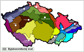
 Map of geological system of Moravia
- Look from Výhon, Akátová tower to the south
- Moravian Dyje-Svratka Vale - look from Dolní Kounice to southeast, Palava Hills on horizon
- Vineyeards under Pálava hills
- Vineyeards under Pálava hills
 Old oak beaten and formed by wind
 Old route in the rock
 Ruins of mediaeval Castle Sirotčí hrádek (Orphans fort)
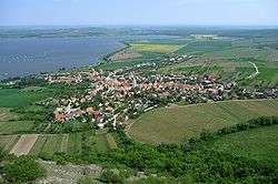
 Outlook from Děvín summit to Pavlov village
 Aerial wiew on Klentnice
References
External links
| Wikimedia Commons has media related to CHKO Pálava. |
- Small-scale hikersmap
- Websites of Palava Protected Landscape Area
- příroda.cz (Nature) in Czech
- Horník, Some results of biogeographic research on meadows in the Dyje-Svratka basin in the Czech Republic
See also
| Wikimedia Commons has media related to Mikulovská vrchovina. |