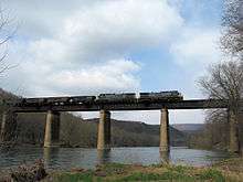
Cumberland Subdivision

The Cumberland Subdivision is a railroad line owned and operated by CSX Transportation in the U.S. states of Maryland and West Virginia. The line runs from Weverton, Maryland west to near Cumberland, Maryland[1] along the old Baltimore and Ohio Rail Road (B&O) main line. At its east end, the Cumberland Subdivision becomes the Metropolitan Subdivision; at its west end (at Mexico, Maryland) it becomes the Cumberland Terminal Subdivision. It meets the Shenandoah Subdivision at Harpers Ferry, West Virginia and the Lurgan Subdivision at Cherry Run, West Virginia.
History

The Cumberland Subdivision was opened in 1842 as part of the B&O's main line.[2]
In 1914 the B&O opened the Magnolia Cutoff, a more direct route through mountain ridges, running 14 miles (23 km) between Hansrote and Paw Paw, West Virginia. The project included construction of four tunnels, two bridges, and many deep rock cuts.[3] The B&O continued to use the original route along the Potomac River, called the "Lowline," until 1961.[4]
In 1987 the subdivision and the rest of the B&O system were merged into CSX.
Current operation
The Cumberland Subdivision supports freight and passenger traffic, with frequent runs of intermodal, autoracks, coal unit trains and mixed freights, and Amtrak trains.[3] The MARC Brunswick Line commuter trains stop at Martinsburg, Duffields, Harpers Ferry, and points east, terminating in Washington, D.C.
See also
References
| Wikimedia Commons has media related to Cumberland Subdivision. |
- ↑ CSX Timetables: Cumberland Subdivision
- ↑ "PRR Chronology, 1842" (PDF). (70.6 KiB), March 2005 Edition
- 1 2 High Iron Online. "Magnolia Cutoff." 2001-09-20.
- ↑ Rail Nutter News. "Magnolia Cutoff." Accessed 2010-11-17.