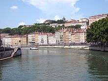
La Croix-Rousse

La Croix-Rousse is a hill (254m) in the city of Lyon, France, as well as the name of a neighborhood located on this hill. The neighborhood is divided into les pentes (slopes, belonging to the city's 1st arrondissement) and le plateau (atop the hill, part of the 4th arrondissement). The name "La Croix-Rousse" (The ginger cross) comes from a reddish-brown stone cross erected there in the 16th century. This zone is served by the metro line C
The appearance of the neighborhood is heavily influenced by the central role that Lyon played in silk industry. The vast majority of buildings in the area feature large vaulted ceilings with exposed wooden rafters. The larger internal height available in these buildings, compared to other areas in Lyon, was necessary to house the tall silk looms that were operated in the area. Of note, also, are the traboules of Croix-Rousse. These are covered passageways used by silk merchants to travel and ferry material between buildings while being sheltered from rain. It has since been subject to gentrification, and now exhibits a vibrant cultural scene. La Croix-Rousse has always possessed a unique atmosphere compared to the rest of the city. As an illustration, some inhabitants call themselves "Croix-roussiens" (Croix-Roussians).
In Lyon, La Croix-Rousse is nicknamed la colline qui travaille (the hill that works) in contrast to the better-known hill to the southwest, Fourvière, which is known as la colline qui prie (the hill that prays). The district started developing in the 18th century when the silk workshops moved here from the Vieux Lyon area. The canuts (silk workers) were subject to extremely poor working conditions. On account of these conditions, they staged many worker uprisings, known as the Canut revolts. The first revolt, in October 1831 is considered to be one of the very first worker uprisings. The area was immortalised in Paul-Jacques Bonzon's book series Les Six Compagnons, which depicts the adventures of seven young working class teenagers from the area.
See also
- Boulevard de la Croix-Rousse
- Canut (silkworkers)
- Canut revolts
- Gros Caillou
Sources
| Wikimedia Commons has media related to La Croix-Rousse. |
- Domenico Pucciarelli, Le rêve au quotidien, de la ruche ouvrière à la ruche alternative, les expériences collectives de la Croix-Rousse, 1975-1995, Atelier de création libertaire, Lyon, 1996.
- Le Monde, A Lyon, la Croix-Rousse demeure un quartier rebelle, 01/08/2003
- Jean Pelletier : Connaître son arrondissement – le 4ème, éditions lyonnaises d’art et d’histoire, ISBN 2-84147-043-1
- Louis F. Lacroux, La Croix-Rousse en flânant, Éditions Xavier Lejeune
- Bernard Collonges, Le quartier des Capucins - Histoire du bas des pentes de la Croix-Rousse, éditions Aléas, septembre 2004, 115 p., ISBN 2-84301-100-0
- Josette Barre, La colline de la Croix-Rousse, Éditions Lyonnaises d’Art et d’Histoire
Coordinates: 45°46′46″N 4°49′39″E / 45.77944°N 4.82750°E