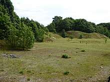
Creeting St Mary Pits
Creeting St Mary Pits is a 5.4 hectare geological Site of Special Scientific Interest south Creeting St Mary in Suffolk.[1][2] It is a Geological Conservation Review site.[3]
These former quarries are the type site for the 'Creeting Sands', which are believed to be intertidal and shallow marine deposits from an early Pleistocene interglacial. It is described by Natural England as a key stratigraphic site.[4]
This site is in three areas, and there is public access to the southern one, but not to the northern ones.
References
Coordinates: 52°09′25″N 1°03′47″E / 52.157°N 1.063°E / 52.157; 1.063
|
|---|
| Biological |
- Abbey Wood, Flixton
- Alde-Ore Estuary
- Arger Fen
- Bangrove Wood, Ixworth
- Barking Woods
- Barnby Broad and Marshes
- Barnham Heath
- Berner's Heath
- Bixley Heath
- Black Ditches, Cavenham
- Blaxhall Heath
- Blo' Norton and Thelnetham Fen
- Bradfield Woods
- Breckland Farmland
- Breckland Forest
- Brent Eleigh Woods
- Bugg's Hole Fen, Thelnetham
- Burgate Wood
- Cavendish Woods
- Cavenham - Icklingham Heaths
- Cherry Hill and The Gallops, Barton Mills
- Chippenhall Green
- Combs Wood
- Cornard Mere
- Crag Pit, Sutton
- Cransford Meadow
- Deadman's Grave, Icklingham
- Deben Estuary
- Dew's Ponds
- Edwardstone Woods
- Elmsett Park Wood
- Eriswell Low Warren
- Fakenham Wood and Sapiston Great Grove
- Fox Fritillary Meadow
- Foxhole Heath
- Freston and Cutler's Woods with Holbrook Park
- Frithy and Chadacre Woods
- The Gardens, Great Ashfield
- Gipping Great Wood
- Glemsford Pits
- The Glen Chalk Caves, Bury St Edmunds
- Gosbeck Wood
- Gromford Meadow
- Groton Wood
- Gypsy Camp Meadows, Thrandeston
- Hay Wood, Whepstead
- High House Meadows, Monewden
- Hintlesham Woods
- Hopton Fen
- How Hill Track
- Iken Wood
- Ipswich Heaths
- Kentwell Woods
- Knettishall Heath
- Lackford Lakes
- Lakenheath Poor's Fen
- Lakenheath Warren
- Landguard Common
- Laurel Farm Meadow
- Leiston - Aldeburgh
- Lineage Wood & Railway Track, Long Melford
- Lingwood Meadows
- Little Blakenham Pit
- Little Heath, Barnham
- London Road Industrial Estate, Brandon
- Lordswell Field
- Maidscross Hill
- Major Farm Meadow
- Metfield Meadow
- Mickfield Meadow
- Middle Wood, Offton
- Milden Thicks
- Minsmere-Walberswick Heaths and Marshes
- Moat Farm Meadows
- Monewden Meadows
- Nacton Meadows
- Newbourne Springs
- Newmarket Heath
- Norton Wood
- Orwell Estuary
- Over and Lawn Woods
- Pakefield to Easton Bavents
- Pakenham Meadows
- Pashford Poor's Fen, Lakenheath
- Potton Hall Fields, Westleton
- RAF Lakenheath
- Redgrave and Lopham Fens
- Rex Graham Reserve
- Riverside House Meadow
- Sandlings Forest
- Sinks Valley, Kesgrave
- Sizewell Marshes
- Snape Warren
- Sotterley Park
- Sprat's Water and Marshes, Carlton Colville
- Stallode Wash, Lakenheath
- Stanton Woods
- Staverton Park and The Thicks, Wantisden
- Stour Estuary
- Sutton and Hollesley Heaths
- Thetford Heaths
- Thorpe Morieux Woods
- Titsal Wood, Shadingfield
- Trundley and Wadgell's Wood, Great Thurlow
- Tunstall Common
- Wangford Warren and Carr
- Weather and Horn Heaths, Eriswell
- West Stow Heath
- Westhall Wood and Meadow
- Weston Fen
- Wilde Street Meadow
- Wortham Ling
|
|---|
| Geological |
- Alde-Ore Estuary
- Aldeburgh Brick Pit
- Aldeburgh Hall Pit
- Bawdsey Cliff
- Bobbitshole, Belstead
- Breckland Forest
- Buckanay Farm Pit, Alderton
- Chillesford Church Pit
- Corton Cliffs
- Crag Farm Pit, Sudbourne
- Crag Pit, Aldeburgh
- Creeting St Mary Pits
- Ferry Cliff, Sutton
- Flixton Quarry
- Gedgrave Hall Pit
- Great Blakenham Pit
- Hascot Hill Pit
- Holton Pit
- Hoxne Brick Pit
- Neutral Farm Pit, Butley
- Pakefield to Easton Bavents
- Ramsholt Cliff
- Red House Farm Pit
- Red Lodge Heath
- Richmond Farm Pit, Gedgrave
- Rockhall Wood Pit, Sutton
- Round Hill Pit, Aldeburgh
- Sandy Lane Pit, Barham
- Stoke Tunnel Cutting, Ipswich
- Stour Estuary
- Sudbourne Park Pit
- Valley Farm Pit, Sudbourne
- Waldringfield Pit
|
|---|
