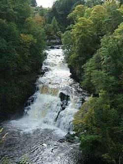
Falls of Clyde (waterfalls)
| Falls of Clyde | |
|---|---|
 Corra Linn in full spate | |
| Location |
|
| Coordinates | 55°39′12″N 3°46′36″W / 55.65333°N 3.77667°WCoordinates: 55°39′12″N 3°46′36″W / 55.65333°N 3.77667°W |
| Total height | 84 feet |
| Number of drops | 4 |
| Watercourse | River Clyde |
The Falls of Clyde is the collective name of four linn (Scots: waterfalls) on the River Clyde near New Lanark, South Lanarkshire, Scotland. The Falls of Clyde comprise the upper falls of Bonnington Linn, Corra Linn, Dundaff Linn, and the lower falls of Stonebyres Linn. Corra Linn is the highest, with a fall of 84 feet. Bonnington Linn (fall of 30 feet), Corra Linn and Dundaff Linn (fall of 10 feet) are above New Lanark and located within the Falls of Clyde Reserve managed by the Scottish Wildlife Trust, a national nature conservation charity. Stonebyres Linn is located several miles downstream from the reserve and New Lanark.
History
The area has long been a popular destination for visitors. The Wordsworths, Coleridge and Sir Walter Scott all visited the Falls. In 1802, William Wordsworth immortalised Corra Linn, the largest of the waterfalls, in verse. Corra Linn has also been painted by a number of artists, including J. M. W. Turner. The name comes from the Gaelic 'currach', a marshy place. A legend gives 'Cora' as a daughter of King Malcolm II, who leapt to her death here whilst trying to escape imagined danger.[1]
Near Corra Linn is the Pavilion, built by Sir John Carmichael of Bonnington, probably in 1708. The Pavilion had mirrors on its back wall, and when the doors were opened visitors had the illusion of standing beneath the falls. The 15th-century Corra Castle is next to Corra Linn. It is now home to a family of rare bats. Corra is Gaelic for "weir", and as Corra Castle's early history is vague, some historians believe it was an early possession of the Weirs, the principle landowning family in the County after the dukes of Hamilton from the 13th to 19th centuries. Corehouse, built in 1844, the home of the Cranstoun family, is nearby. At Stonebyres Linn the ruins of 15th-century Stonebyres Castle may be seen.
Falls of Clyde Site of Special Scientific Interest
| Falls of Clyde | |
|---|---|
| formerly the Corehouse Nature Reserve | |
|
The natural amphitheatre at the base of Corra Linn. | |
 Location of the Falls of Clyde within South Lanarkshire, Scotland | |
| Location | South Lanarkshire, Scotland, United Kingdom |
| Nearest city | Lanark |
| Coordinates | 55°39′12″N 3°46′36″W / 55.65333°N 3.77667°W |
| Established |
1960s: The Corehouse Nature Reserve is established by Colonel Cranstoun of Corehouse 1971: Falls of Clyde is designated a Site of Special Scientific Interest 2007: The Falls of Clyde is amalgamated into the Clyde Valley Woodlands National Nature Reserve [2][3] |
| Governing body | Scottish Wildlife Trust |
|
scottishwildlifetrust | |
The Falls of Clyde Site of Special Scientific Interest (formerly the Corehouse Nature Reserve), a part of the Clyde Valley Woodlands National Nature Reserve, is an area of mixed woodland, including semi-natural native oakwoods and some areas of conifer plantation. It provides suitable habitat for badgers, roe deer, and over 100 species of bird. The site is well known for its resident breeding pair of peregrine falcons, which are protected during the breeding season by Operation Peregrine, providing security for the birds and a chance for the public to view the birds through scopes and CCTV. On 22 October 2011 at 1500 GMT a very rare pine marten was spotted within the reserve and was photographed. Within the reserve the Clyde River is suitable habitat for otters and kingfishers as well as the protected brook lamprey.
The Falls of Clyde Visitor Centre, operated by the Scottish Wildlife Trust, features exhibits about the waterfalls, the woodland and the area animals, including a special bat display.
Hydro-electric power
The Lanark Hydro Electric Scheme is situated between Corra Linn and Dundaff Linn, with a water inlet at Bonnington Linn. This plant was built in 1927 and was the first hydro-electric power station in Scotland. It generates approximately eleven megawatts of power. Another hydro-electric power station is situated near Stonebyres Linn, about three miles south of Corra Linn. This generates approximately six megawatts of power. Both stations are owned and operated by Scottish Power.
Clyde Walkway
The Clyde walkway long distance path passes all four falls and ends at Bonnington Linn.
Photograph gallery
 Corra Linn
Corra Linn in the autumn 
The Clyde at New Lanark 
Dundaff Linn at New Lanark in winter Bonnington Linn 
Stonebyres hydroelectric Power Station Bonnington hydroelectric power station - The pipes supplying water from the Clyde to Bonnington hydroelectric power station
The ruins of the Hall of Mirrors or Bonnington Pavilion overlooking Corra Linn The old iron bridge at the Bonnington Falls
See also
Maps
Annotated map of Lanark, New Lanark and Falls of Clyde
References
- ↑ Westwood, Jennifer and Kingshill, Jennifer (2009). The Lore of Scotland. A Guide to Scottish Legends. London : Random House. ISBN 978-1-905211-62-3. p. 176
- ↑ Blow, Stephen (January 2010). "The Falls of Clyde Wildlife Reserve Management Plan 2009 - 2019" (PDF). Scottish Wildlife Trust. p. 2. Retrieved 21 January 2012.
- ↑ "The Story of the Clyde Valley Woodlands National Nature Reserve" (PDF). Scotland's National Nature Reserves. Scottish National Heritage. 2010. pp. i. Retrieved 21 January 2012.
Historical Tours in the Clyde Valley. Published by the Clyde Valley Tourist Association and the Lanark & District Archaeological Association. Printed by Robert MacLehose and Company Limited, Renfrew, Scotland. 1982.
External links
| Wikimedia Commons has media related to Falls of Clyde (waterfalls). |