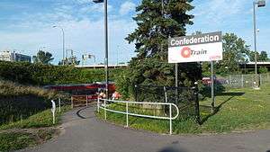
Confederation station
Confederation | |||||||||||
|---|---|---|---|---|---|---|---|---|---|---|---|
 | |||||||||||
| Coordinates | 45°22′36.7″N 75°41′5.7″W / 45.376861°N 75.684917°WCoordinates: 45°22′36.7″N 75°41′5.7″W / 45.376861°N 75.684917°W | ||||||||||
| Owned by | OC Transpo | ||||||||||
| Platforms | At-grade - single | ||||||||||
| Tracks | 1 | ||||||||||
| Construction | |||||||||||
| Parking | No | ||||||||||
| Bicycle facilities | No | ||||||||||
| Disabled access | Yes | ||||||||||
| History | |||||||||||
| Opened | 2001 | ||||||||||
| Services | |||||||||||
| |||||||||||
Confederation is an O-Train station along the Trillium Line located near Heron Road and Bronson Avenue in Ottawa, Ontario, which primarily serves the Government of Canada offices in the Confederation Heights area, and students from Brookfield High School. Recently, a pedestrian and cyclist path was built, providing a direct link between Confederation Station and Brookfield Road.
The station is named for the area, Confederation Heights.
Facilities
- Accessibility: Yes - walkway to Campus Avenue
- Washrooms: None
- Nearby: Government of Canada building 501 Heron Road, Sir Leonard Tilley Building, Canada Post, Edward Drake Building, Revenue Canada Data Centre
Service
The following routes serve Confederation station:[1]
O-TRAIN Trillium Line
87 88 104 107 111 290
References
- ↑ "System Map" (PDF). OC Transpo. 2015. Retrieved March 2016. Check date values in:
|access-date=(help)
External links
![]() Media related to Confederation Station at Wikimedia Commons
Media related to Confederation Station at Wikimedia Commons
This article is issued from
Wikipedia.
The text is licensed under Creative Commons - Attribution - Sharealike.
Additional terms may apply for the media files.