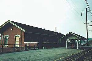
Coatesville station
Coatesville | ||||||||||||||||||||||||||||||||||||||||||||||
|---|---|---|---|---|---|---|---|---|---|---|---|---|---|---|---|---|---|---|---|---|---|---|---|---|---|---|---|---|---|---|---|---|---|---|---|---|---|---|---|---|---|---|---|---|---|---|
 The platform at Coatesville with the disused building beyond. | ||||||||||||||||||||||||||||||||||||||||||||||
| Location |
Third Avenue and Fleetwood Street Coatesville, PA 19320 | |||||||||||||||||||||||||||||||||||||||||||||
| Coordinates | 39°59′9″N 75°49′15″W / 39.98583°N 75.82083°WCoordinates: 39°59′9″N 75°49′15″W / 39.98583°N 75.82083°W | |||||||||||||||||||||||||||||||||||||||||||||
| Line(s) | Keystone Corridor (Main Line) | |||||||||||||||||||||||||||||||||||||||||||||
| Platforms | 2 side platforms | |||||||||||||||||||||||||||||||||||||||||||||
| Tracks | 3 | |||||||||||||||||||||||||||||||||||||||||||||
| Connections |
| |||||||||||||||||||||||||||||||||||||||||||||
| Other information | ||||||||||||||||||||||||||||||||||||||||||||||
| Station code | COT | |||||||||||||||||||||||||||||||||||||||||||||
| Traffic | ||||||||||||||||||||||||||||||||||||||||||||||
| Passengers (2016) |
15,527[1] | |||||||||||||||||||||||||||||||||||||||||||||
| Services | ||||||||||||||||||||||||||||||||||||||||||||||
| ||||||||||||||||||||||||||||||||||||||||||||||
Coatesville is an Amtrak rail station located in the far western suburbs of Philadelphia at Third Avenue and Fleetwood Street in Coatesville, Pennsylvania. It is served by most Amtrak Keystone Service trains. An old railroad station building exists at the stop, but is not currently used. There is no ticket office at this station. Coatesville is one of the least-used stations on the Keystone Corridor east of Harrisburg. This may be due to a lack of parking as well as its proximity to Thorndale Station on the SEPTA Paoli/Thorndale Line. SEPTA once served this station until 1996 when the agency was forced to close a $75 million gap and has since truncated its service.[2]
In summer 2013, the Chester County Economic Development Council announced the selection of a developer for a project to revitalize the Coatesville station area. Total costs will be dependent on final design and engineering estimates, but the Pennsylvania Department of Transportation (PennDOT) has pledged approximately $20 million to the project. Under the plan, a new station with parking would be built just east of the historic depot, along the tracks between Third and Fourth Avenues.[3]
In addition to the rail service, Krapf's Transit Route A bus stops about 1/4 mile south of the station.
References
- ↑ "Amtrak State Fact Sheet, FY2016, Commonwealth of Pennsylvania" (PDF). Amtrak. November 2016. Retrieved 7 December 2016.
- ↑ "Septa Plan Draws Wail From Riders R5 Service To Parkesburg And Coatesville May Be Eliminated.".
- ↑ "Coatesville Station". Amtrak's Great American Stations. Retrieved 3 November 2014.
External links
- Amtrak – Stations – Coatesville, PA
- Coatesville Amtrak Station (USA RailGuide -- TrainWeb)
- Coatesville, PA (COT) (Amtrak's Great American Stations)