Clarita, Oklahoma
| Clarita, Oklahoma | |
|---|---|
| Unincorporated community | |
 Clarita  Clarita Location within the state of Oklahoma | |
| Coordinates: 34°28′58″N 96°26′0″W / 34.48278°N 96.43333°WCoordinates: 34°28′58″N 96°26′0″W / 34.48278°N 96.43333°W | |
| Country | United States |
| State | Oklahoma |
| County | Coal |
| Elevation | 676 ft (206 m) |
| Time zone | Central (CST) (UTC-6) |
| • Summer (DST) | CDT (UTC-5) |
| GNIS feature ID | 1091387 |
Clarita is a small unincorporated community in Coal County, Oklahoma, United States.[1] The post office was established January 19, 1910.
Clarita's school district, Olney Public School District, is one of the smallest public school districts in the state of Oklahoma. For the most recent data available, for a combined district, K-12, Olney finished between Boley (51) and Sweetwater (60), with 58 students. Olney School is now closed although the reunion is still held at the lunch room.[2]
References
External links
Municipalities and communities of Coal County, Oklahoma, United States | ||
|---|---|---|
| Cities | 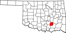 | |
| Towns | ||
| Unincorporated communities | ||
| Footnotes | ‡This populated place also has portions in an adjacent county or counties | |
This article is issued from
Wikipedia.
The text is licensed under Creative Commons - Attribution - Sharealike.
Additional terms may apply for the media files.