Cima Fontanaccia
| Cima Fontanaccia | |
|---|---|
 The summit | |
| Highest point | |
| Elevation | 1,153 m (3,783 ft) .[1] |
| Prominence | 65 m (213 ft) [2] |
| Coordinates | 44°25′17.73″N 08°36′42.63″E / 44.4215917°N 8.6118417°ECoordinates: 44°25′17.73″N 08°36′42.63″E / 44.4215917°N 8.6118417°E |
| Naming | |
| Translation | Bad spring summit (Italian) |
| Geography | |
 Cima Fontanaccia Location in Italy | |
| Location | Liguria, Italy |
| Parent range | Ligurian Appennines |
| Climbing | |
| First ascent | ancestral |
| Easiest route | South-West ridge |
Cima Fontanaccia is a 1153 metres high mountain in the Ligurian Apennines, in Italy.
Geography

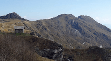
Cima Fontanaccia (centre) between Bric Resunnou (left) and Monte Rama (right).
The mountain is located in the province of Genova, in Liguria, and belongs to the municipality of Cogoleto. It stands on a brief ridge which, starting from the main chain of the Apennines near Rocca del Lago, heads south-east towards the Ligurian Sea and after Cima Fontanaccia continues with Monte Rama and Bric Camulà.[3]
Access to the summit
The summit of Cima Fontanaccia can be accessed following a short unmarked trak departing from the foothpath connecting Monte Rama and Rifugio Prato Rotondo.[4]
Nature conservation
The mountain si included in the Parco naturale regionale del Beigua.[5]
Mountain huts
- Rifugio Prato Rotondo (1108 m).
- Rifugio Padre Rino (903 m)[6]
References
- ↑ Limiti Amministrativi (Comunali, Provinciali, Regionali) sc. 1:25000 - ed. 2011; Regione Liguria, on-line map on geoportale.regione.liguria.it.
- ↑ Key col: saddle near Rocca del Lago (1088 m)
- ↑ Istituto Geografico Centrale - Carta dei sentieri 1:50.000 n. 16 Genova - Varazze -Ovada
- ↑ Monte Rama (1148 mt), Cima Fontanaccia (1153 m) e Bric Damè (1193 m), article of users peter86 e laura61, on www.hikr.org
- ↑ Parco Naturale Regional del Beigua (in Italian) (in English) (in German) (in French)
- ↑ Rama (Monte) anello da Case Soprane per il monte Argentea, article of user franco@A on www.gulliver.it
![]() Media related to Cima Fontanaccia at Wikimedia Commons
Media related to Cima Fontanaccia at Wikimedia Commons
This article is issued from
Wikipedia.
The text is licensed under Creative Commons - Attribution - Sharealike.
Additional terms may apply for the media files.