Chopicalqui
| Chopicalqui | |
|---|---|
 | |
| Highest point | |
| Elevation | 6,354 m (20,846 ft) |
| Coordinates | 9°05′12″S 77°34′26″W / 9.08667°S 77.57389°WCoordinates: 9°05′12″S 77°34′26″W / 9.08667°S 77.57389°W |
| Geography | |
 Chopicalqui Peru | |
| Location | Yungay Province, Peru |
| Parent range | Cordillera Blanca (Andes) |
| Climbing | |
| First ascent | August 3, 1932 by H. Hoerlin, E. Schneider, P. Borchers, E. Hein |

Chopicalqui
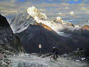
Chopicalqui[1][2] or Chopicallqui[3] (possibly from Ancash Quechua kallki ravine)[4] is a mountain in the Cordillera Blanca area in the Andes of Peru.[1] With a summit elevation of 6,354 metres (20,846 ft) above sea level[1] it is one of the highest peaks of the Cordillera Blanca. It lies in Yungay Province, Ancash, between the mountains Huascarán and Contrahierbas.[1][3]
Climbing
The standard climbing route is the Southwest Ridge, a moderate snow climb that is popular with climbers and can be crowded at times. It possesses a difficulty rating of PD+/AD- on the French System for grading alpine routes but deep snow on the summit slopes causes most failures for parties attempting the ridge.[5]
Other established climbing routes include the following:
References
- 1 2 3 4 Alpenvereinskarte 0/3a. Cordillera Blanca Nord (Peru). 1:100 000. Oesterreichischer Alpenverein. 2005. ISBN 3-928777-57-2.
- ↑ Biggar, John (2005). The Andes: A Guide for Climbers. Andes. p. 75. ISBN 9780953608720.
- 1 2 Peru 1:100 000, Carhuás (19-h). IGN (Instituto Geográfico Nacional - Perú).
- ↑ Leonel Alexander Menacho López, Yachakuqkunapa Shimi Qullqa, Anqash Qhichwa Shimichaw (Ministerio de Educación), Wordbook Ancash Quechua-Spanish: Kallki. - Encañada.
- 1 2 3 B. Johnson, Classic Climbs of the Cordillera Blanca Peru, 2009
This article is issued from
Wikipedia.
The text is licensed under Creative Commons - Attribution - Sharealike.
Additional terms may apply for the media files.