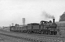
Chiltern Green railway station
| Chiltern Green | |
|---|---|
|
A local goods train near Chiltern Green in 1950 | |
| Location | |
| Place | New Mill End |
| Area | District of Central Bedfordshire |
| Operations | |
| Pre-grouping | Midland Railway |
| Platforms | 2 |
| History | |
| 13 July 1868 | Opened as Chiltern Green |
| 1 December 1891 | Renamed Chiltern Green for Luton Hoo |
| 7 April 1952 | Closed [1] |
| Disused railway stations in the United Kingdom | |
|
Closed railway stations in Britain A B C D–F G H–J K–L M–O P–R S T–V W–Z | |
|
| |
| Railways around Luton | ||||||||||||||||||||||||||||||||||||||||||||||||||||||||||||||||||||||||||||||||||||||||||||||||||||||||||||||||||||||
|---|---|---|---|---|---|---|---|---|---|---|---|---|---|---|---|---|---|---|---|---|---|---|---|---|---|---|---|---|---|---|---|---|---|---|---|---|---|---|---|---|---|---|---|---|---|---|---|---|---|---|---|---|---|---|---|---|---|---|---|---|---|---|---|---|---|---|---|---|---|---|---|---|---|---|---|---|---|---|---|---|---|---|---|---|---|---|---|---|---|---|---|---|---|---|---|---|---|---|---|---|---|---|---|---|---|---|---|---|---|---|---|---|---|---|---|---|---|---|
| ||||||||||||||||||||||||||||||||||||||||||||||||||||||||||||||||||||||||||||||||||||||||||||||||||||||||||||||||||||||
Chiltern Green railway station was built by the Midland Railway in 1868 on its extension to St. Pancras.
The station was located in New Mill End but took its name from the small hamlet of Chiltern Green about a mile away. Adjacent to it was the GNR station of Luton Hoo also located in New Mill End. The small hamlet of New Mill End is unique in having two railway stations (Chiltern Green and Luton Hoo) neither of which, after 1 December 1891, were named after the village they served. The two lines ran side by side at this point, the Midland into Luton Midland Road, the GNR from Hatfield into Luton Bute Street.[2]
The station closed in 1952 due to competition from Luton Hoo station, only 600 yards (500 m) away. The station buildings survive to this day as a private home. The platform on the station building side partly survives but is overgrown and difficult to see when passing in a train. The other platform was removed when the line was electrified.
| Preceding station | |
Following station | ||
|---|---|---|---|---|
| Luton Airport Parkway Line and station open |
Midland Railway Midland Main Line |
Harpenden Line and station open | ||
References
Coordinates: 51°51′0.9″N 0°22′10″W / 51.850250°N 0.36944°W
