Chapel Island Formation
| Chapel Island Formation Stratigraphic range: Terminal Ediacaran – Fortunian[1] | |
|---|---|
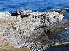 Ediacaran-Cambrian boundary section at Fortune Head, NL, in the Chapel Island Fm. The darker units constituting the bottom c. 2-3 m of the outcrop correspond to unit 1; the GSSP lies a couple of m into Unit 2. | |
| Type | Formation |
| Unit of | Young's Cove Group[2] |
| Underlies | Random Fm[3] |
| Overlies | Rencontre Fm[3] |
| Thickness | Hundreds of metres[3] |
| Location | |
| Region | Newfoundland |
| Country | Canada |
 Outcrop distribution in southeast Newfoundland | |
The Chapel Island Formation is a sedimentary formation from the Burin Peninsula, Newfoundland, Canada. It is an over 1000 meter thick succession of siliciclastic deposits that were deposited during the latest Ediacaran and earliest Cambrian.
Stratigraphy
Sequence stratigraphy shown here:[4] The formation starts in an intertidal zone, then as the Cambrian progresses, it becomes deeper water (outer shelf) as a general trend. The Chapel Island Formation lies on top of the Rencontre Formation and below the Random Formation.[5] It is 900 m thick in Fortune Bay as a fault-bounded basin, ; grey-green siltstones and sandstones, with minor limestone beds near its top. Small Shelly Fossils have been recovered - primitive taxa only. Setting nearshore or open shelf.[3]
Subdivision
The Formation is divided into six members, numbered 1 to 5, with member 2 split into 2A and 2B. The Proterozoic/Cambrian-boundary occurs 20.66 m above the base of the CIF, 2.4 m into Member 2A.[5]
The lowest occurrence of T.pedum in the succession is 16.25 m above the base of the unit.[6]
Overview of sedimentology and facies available in [7]:1282
References
- ↑ Gehling, James G.; Jensen, Sören; Droser, Mary L.; Myrow, Paul M.; Narbonne, GUY M. (2001). "Burrowing below the basal Cambrian GSSP, Fortune Head, Newfoundland". Geological Magazine. 138 (2). doi:10.1017/S001675680100509X.
- ↑ "Newfoundland and Labrador Geoscience Atlas".
- 1 2 3 4 Smith, Simon A.; Hiscott, Richard N. (December 1984). "Latest Precambrian to Early Cambrian basin evolution, Fortune Bay, Newfoundland: fault-bounded basin to platform". Canadian Journal of Earth Sciences. 21 (12): 1379–1392. Bibcode:1984CaJES..21.1379S. doi:10.1139/e84-143.
- ↑ Myrow, Paul M.; Hiscott, Richard N. (September 1993). "Depositional history and sequence stratigraphy of the Precambrian-Cambrian boundary stratotype section, Chapel Island Formation, southeast Newfoundland". Palaeogeography, Palaeoclimatology, Palaeoecology. 104 (1–4): 13–35. doi:10.1016/0031-0182(93)90117-2.
- 1 2 Gehling, James G.; Sören Jensen; Mary L. Droser; Paul M. Myrow; Guy M. Narbonne (2001). "Burrowing below the basal Cambrian GSSP, Fortune Head, Newfoundland" (PDF). Geological Magazine. 213-218. 138. Archived from the original (PDF) on 28 October 2014. Retrieved 3 November 2012.
- ↑ Gehling, James G.; Jensen, Sören; Droser, Mary L.; Myrow, Paul M.; Narbonne, GUY M. (2001). "Burrowing below the basal Cambrian GSSP, Fortune Head, Newfoundland". Geological Magazine. 138 (2). doi:10.1017/S001675680100509X.
- ↑ Narbonne, G.M., Myrow, P.M., Landing, E., and Anderson, M.M. (1987). A candidate stratotype for the Precambrian- Cambrian boundary, Fortune Head, Burin Peninsula, southeastern Newfoundland. Can. J. Earth Sci. 24, 1277–1293.