Chai Nat Province
| Chai Nat ชัยนาท | ||
|---|---|---|
| Province | ||
| ||
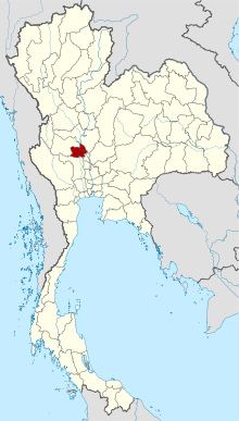
 Map of Thailand highlighting Chai Nat Province | ||
| Country | Thailand | |
| Seat of government | Chai Nat | |
| Government | ||
| • Governor | Nimit Wanchaithanawong (since October 2016) | |
| Area | ||
| • Total | 2,469.7 km2 (953.6 sq mi) | |
| Area rank | Ranked 64th | |
| Population (2014) | ||
| • Total | 332,283 | |
| • Rank | Ranked 62nd | |
| • Density | 130/km2 (350/sq mi) | |
| • Density rank | Ranked 26th | |
| Time zone | ICT (UTC+7) | |
| ISO 3166 code | TH-18 | |
Chai Nat (Thai: ชัยนาท, pronounced [t͡ɕʰāj nâːt]) is one of the central provinces (changwat) of Thailand.[1] Neighbouring provinces are (from north clockwise) Nakhon Sawan, Sing Buri, Suphan Buri, and Uthai Thani. The town of Chai Nat is 188 km north of Bangkok.[2]
Geography
Chai Nat is on the flat river plain of central Thailand's Chao Phraya River valley. In the south of the province the Chao Phraya Dam (formerly Chai Nat Dam) impounds the Chao Phraya River, both for flood control as well as to divert water into the country's largest irrigation system for the irrigation of rice paddies in the lower river valley. The dam, part of the Greater Chao Phraya Project, was finished in 1957 and was the first dam constructed in Thailand.
History
Chai Nat was first established during the Ayutthaya period and was used as a successful base of operations for confronting the Burmese army. As the Burmese were defeated every time, the area earned the name Chai Nat, "place of victory".[1]
Symbols
The provincial seal shows a dhammachakka and in the background a mountain. It refers to the Dhammachak Buddha image housed in the wihaan of Wat Dhammamoen, built on the slope of a mountain.[3]
The provincial tree is the Bael fruit tree (Aegle marmelos), and the provincial flower the Rainbow Shower tree (Cassia javanica).
The slogan of the province is Venerable Luangpu Suk, renowned Chao Phraya Dam, famous bird park and tasty khao taengkwa pomelo.
Administrative divisions
Chai Nat is divided into eight districts (amphoe). The districts are further subdivided into 53 sub-districts (tambon) and 474 villages (muban).
|
|
References
External links
| Wikimedia Commons has media related to Chainat. |
 Chai Nat travel guide from Wikivoyage
- Chainat Bird Park
- Website of province (Thai only)
- Chainat provincial map, coat of arms and postal stamp
| Adjacent places of Chai Nat Province | ||||
|---|---|---|---|---|
 |
Nakhon Sawan Province |  | ||
| Uthai Thani Province | |
|||
| ||||
| | ||||
| Suphanburi Province | Singburi Province | |||
Coordinates: 15°11′06″N 100°07′29″E / 15.18500°N 100.12472°E

