Cerveteri
| Cerveteri | |
|---|---|
| Comune | |
|
Banditaccia Necropolis | |
 Cerveteri Location of Cerveteri in Italy | |
| Coordinates: 42°00′N 12°06′E / 42.000°N 12.100°E | |
| Country | Italy |
| Region | Lazio |
| Province / Metropolitan city | Rome |
| Area | |
| • Total | 134.43 km2 (51.90 sq mi) |
| Elevation | 81 m (266 ft) |
| Population (30 September 2015) | |
| • Total | 37,326 |
| • Density | 280/km2 (720/sq mi) |
| Time zone | CET (UTC+1) |
| • Summer (DST) | CEST (UTC+2) |
| Website | Official website |

Cerveteri [tʃerˈvɛːteri] is a town and comune of northern Lazio in the region of the Metropolitan City of Rome. Known by the ancient Romans as Caere, and previously by the Etruscans as Caisra or Cisra, and as Agylla (or Άγυλλα) by the Greeks, its modern name derives from Caere Vetus used in the 13th c. to distinguish it from Caere Novum (the current town).
It is famous for the site of the ancient Etruscan city[1] which was one of the most important Etruscan cities with an area more than 15 times larger than today's town.
Caere was one of the city-states of the Etruscan League and at its height, around 600 BC, its population was perhaps around 25,000 - 40,000 people.[2][3][4][5][6]
 | |
| UNESCO World Heritage Site | |
|---|---|
| Location |
Province of Rome, Italy |
| Coordinates | 42°00′N 12°06′E / 42°N 12.1°E |
| Area | 134.32 km2 (1.4458×10⁹ sq ft) |
| Criteria | i, iii, iv |
| Reference | 1158 |
| Inscription | 2004 (28th Session) |
| Website |
www |
 Location of Cerveteri | |
Site
The ancient city was situated about 7 km from the sea, a location which made it a wealthy trading town derived originally from the iron ore mines in the Tolfa hills.[7]
It had three sea ports including Pyrgi, connected to Caere by a road approximately 13 km long and 10 metres wide, and Punicum.
Pyrgi was also famous for its sanctuary of monumental temples from 510 BC, built by the king of Caere and dedicated to the goddesses Leucothea and Ilithyia, of which impressive and beautiful sculptures are exhibited at the Villa Giulia.
History
Monuments
Little is known of the ancient city although six temples are known from various sources. Two of them have been excavated, one of Hera, the other in the north of the city. Parts of the city walls are still visible today and excavations opened up a theatre. There were three necropoli.
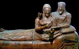
The contents of the tombs excavated, often chaotically and illegally, over the last few centuries have yielded rich and exquisite objects, including ceramics and jewellery which today grace many of the worlds museums. One famous and important work of art is the Sarcophagus of the Spouses.


Necropolis of the Banditaccia

The most famous attraction of Cerveteri is the Necropoli della Banditaccia, which has been declared by UNESCO a World Heritage Site together with the necropolis in Tarquinia. It covers an area of 400 hectares (990 acres), of which 10 hectares (25 acres) can be visited, encompassing a total of ca. 1,000 tombs often housed in characteristic mounds. It is the largest ancient necropolis in the Mediterranean area. The name Banditaccia comes from the leasing (bando) of areas of land to the Cerveteri population by the local landowners.
The tombs date from the 9th century BC (Villanovan culture) to the later Etruscan period (3rd century BC). The earliest tombs are in the shape of a pit, in which the ashes of the dead were housed; also simple potholes are present.
The most important tombs include:
- Tomb Regolini-Galassi with rich gold finds from the mid-7th century
- Tomb of the capitals (Tomba dei Capitelli), middle 6th century
- Tomb of the shields and chairs (Tomba degli Scudi e delle Sedie), middle 6th century
- Tomb of the Painted Lions (Tomba dei Leoni dipinti), 620 BC
- Tomb of the Reliefs (Tomba dei Rilievi), 4th - 2nd century
- Tomb of the Sea Waves (Tomba delle Onde Marine), 4th-3rd century
- Tomb of the Alcove (Tomba dell'Alcova), 4th - 3rd century
- Tomba della capanna
- Tomba dei Vasi Greci
- Tomba dei Doli
- Tomba calabresi
From the later Etruscan period are two types of tombs: tumulus-type tombs and the so-called "dice", the latter being simple square tombs built in long rows along roads within the necropolis. The visitable area contains two such roads, the Via dei Monti Ceriti and the Via dei Monti della Tolfa (6th century BC).
The tumuli are circular structures built in tuff, and the interiors, carved from the living rock, house a reconstruction of the house of the dead, including a corridor (dromos), a central hall, and several rooms. Modern knowledge of Etruscan daily life is largely dependent on the numerous decorative details and finds from such tombs. One of the most famous tombs is the Tomb of the Reliefs, identified from an inscription as belonging to the Matuna family and provided with an exceptional series of frescoes, bas-reliefs and sculptures portraying a large series of contemporary life tools.[8][9]
The most recent tombs date from the 3rd century BC. Some of them are marked by external cippi, which are cylindrical for men, and in the shape of a small house for women.
A large number of finds excavated at Cerveteri are in the National Etruscan Museum, Rome, with others in the Vatican Museums and many other museums around the world. Others, mainly pottery, are in the Archaeological Museum at Cerveteri itself.
Others
- The Rocca (castle)
- Church of Santa Maria Maggiore, including a medieval section reachable from the 1950s addition through a triumphal arch.
- Palazzo Ruspoli, rebuilt as baronal palace by the Orsini in 1533. The portico and the loggia on the façade are from the 17th century. It is connected to Santa Maria Maggiore through a passetto (enclosed bridge), built in 1760.
- The small church of Sant'Antonio Abate, with a 1472 fresco by Lorenzo da Viterbo.
- The medieval burgh of Ceri
- Castle of Cerenova
Cerveteri DOC
Around the city of Cerveteri is an Italian DOC wine region that produces red and white blended wines. The red wines are blends of 60% Sangiovese and Montepulciano, 25% Cesanese and up to 30% of Canaiolo, Carignan and Barbera. The grapes are limited to a harvest yield of 15 tonnes/ha and the final wine must have a minimum alcohol level of 11%. The white wines are composed of a minimum blend of 50% Trebbiano Romagnolo and Giallo, a maximum of 35% Malvasia di Candia and a maximum of 15% Friulano, Verdicchio, Bellone and Bombino bianco. The grapes are limited to a harvest yield of 14 tonnes/ha and the final wine must have a minimum alcohol level of 12%.[10]
Ancient bishopric
For the ancient bishopric that originally had its seat in Cerveteri and is now a titular see, see Caere.
Twin cities
References
- ↑ Quilici, L.; S. Quilici Gigli, DARMC; J. Becker, R.; Talbert; T. Elliott; S. Gillies. "Places: 422859 (Caere)". Pleiades. Retrieved October 20, 2014.
- ↑ Pounds, N.J.G. (1976). An Historical Geography of Europe 450 B.C.-A.D. 1330. Cambridge University Press. ISBN 9780521291262.
- ↑ Museo nazionale di Villa Giulia; Moretti, A.M.S.; Italy. Soprintendenza archeologica per l'Etruria meridionale (2001). The Villa Giulia National Etruscan Museum: Short Guide. L'Erma di Bretschneider. ISBN 9788882650124.
- ↑ Jean MacIntosh Turfa (26 June 2013). The Etruscan World. Routledge. pp. 1774–. ISBN 1-134-05530-7.
- ↑ Normal J. G. Pounds (16 December 1976). An Historical Geography of Europe 450 B.C.-A.D. 1330. CUP Archive. pp. 54–. ISBN 978-0-521-29126-2.
- ↑ John Morris Roberts (1993). A Short History of the World. Oxford University Press. pp. 110–. ISBN 978-0-19-511504-8.
- ↑ Karl-Wilhelm Weber: Geschichte der Etrusker, Berlin, Köln, Mainz 1979, ISBN 3170052144, S. 38
- ↑ Fred Kleiner (8 January 2009). Gardner's Art through the Ages: The Western Perspective. Cengage Learning. pp. 181–. ISBN 0-495-57360-4.
- ↑ Horst Blanck; Giuseppe Proietti; Italy. Soprintendenza archeologica per l'Etruria meridionale (1986). La Tomba dei Rilievi di Cerveteri. De Luca.
- ↑ P. Saunders Wine Label Language pg 137 Firefly Books 2004 ISBN 1-55297-720-X
External links
 Media related to Cerveteri at Wikimedia Commons

Coordinates: 42°00′N 12°06′E / 42.000°N 12.100°E