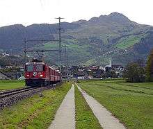
Castrisch (Rhaetian Railway station)
Castrisch | |||
|---|---|---|---|
 Castrisch station | |||
| Location |
Via dalla Staziun 98 7126 Castrisch Surselva, Graubünden Switzerland | ||
| Coordinates | 46°46′43″N 09°13′59″E / 46.77861°N 9.23306°ECoordinates: 46°46′43″N 09°13′59″E / 46.77861°N 9.23306°E | ||
| Elevation | 705 m (2,313 ft) | ||
| Owned by | Rhaetian Railway (RhB) | ||
| Operated by | RhB | ||
| Line(s) | Landquart - Disentis/Mustér | ||
| Distance |
40.74 km (25.31 mi) from Landquart | ||
| History | |||
| Opened | 1 June 1903 | ||
| Electrified | 22 May 1922 | ||
| |||
| Location | |||
 Castrisch Location within Switzerland | |||
Castrisch is a railway station on the line of the Rhaetian Railway that links Chur and Disentis in the Swiss canton of Graubünden. It serves the village of Castrisch in the municipality of Ilanz/Glion.[1][2]
Services
The station is served by trains on the RE3/R31 services, which provide 1 train per hour in both directions.[2][3]
| Preceding station | Rhätische Bahn | Following station | ||
|---|---|---|---|---|
toward Disentis/Mustér | RE3 RE910/RE920 | toward Scuol-Tarasp |
||
| R31 R910/R920 Limited service | toward Landquart |
Gallery
 The station can be seen in the centre of the image
 Rail line through Castrisch
References
- ↑ "106 - Glarnerland - Bündnerland" (Map). Castrisch railway station (2015 ed.). 1:100 000. National Map 1:100'000. Federal Office of Topography - swisstopo. ISBN 978-3-302-50106-2. Retrieved 2017-06-05 – via map.geo.admin.ch.
- 1 2 "Rail network". Rhaetian Railway. Archived from the original on 2017-06-05. Retrieved 2017-06-05.
- ↑ "Chur–Disentis/Mustér–Andermatt" [Official Timetable of Switzerland] (PDF). Offiziellen Kursbuches der Schweiz (in German). Archived (PDF) from the original on 2017-06-06. Retrieved 2017-06-06.
External links
This article is issued from
Wikipedia.
The text is licensed under Creative Commons - Attribution - Sharealike.
Additional terms may apply for the media files.
