Carson Airport
| Carson Airport Carson City Airport | |||||||||||
|---|---|---|---|---|---|---|---|---|---|---|---|
 | |||||||||||
| Summary | |||||||||||
| Airport type | Public | ||||||||||
| Operator | Carson City Airport Authority | ||||||||||
| Serves | Carson City, Nevada | ||||||||||
| Elevation AMSL | 4,704 ft / 1,432 m | ||||||||||
| Coordinates | 39°11′32″N 119°44′04″W / 39.19222°N 119.73444°W | ||||||||||
| Website | http://flycarsoncity.com | ||||||||||
| Map | |||||||||||
 CXP  CXP Location of airport in Nevada / United States | |||||||||||
| Runways | |||||||||||
| |||||||||||
| Statistics (2009) | |||||||||||
| |||||||||||
Carson Airport[1][3] (IATA: CSN, ICAO: KCXP, FAA LID: CXP) (Carson City Airport) is three miles northeast of Carson City,[1] the capital of Nevada. It is operated by the Carson City Airport Authority.[2] The FAA's National Plan of Integrated Airport Systems for 2009–2013 categorized it as a reliever airport.
Many U.S. airports use the same three-letter location identifier for the FAA and IATA, but this airport is CXP to the FAA[1] and CSN to the IATA[4] (which assigned CXP to Tunggul Wulung Airport in Java, Indonesia).[5]
Facilities

Carson Airport covers 632 acres (256 ha) at an elevation of 4,697 feet (1,432 m). Its runway (9/27) is 5,906 by 75 feet (1,800 x 23 m).[1]
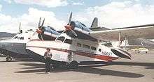
In the year ending June 30, 2009 the airport had 83,500 aircraft operations, average 228 per day: 91% general aviation and 9% air taxi. 223 aircraft were then based at this airport: 76% single-engine, 11% multi-engine, 3% jet, <1% helicopter, 1% glider and 9% ultralight.[1] Based aircraft include several amphibians that fly to and land on nearby Lake Tahoe.
References
- 1 2 3 4 5 6 FAA Airport Master Record for CXP (Form 5010 PDF). Federal Aviation Administration. August 27, 2009.
- 1 2 Carson City Airport, official site
- ↑ "Diagram of Carson Airport (CXP)" (PDF). (29.6 KB). Nevada Department of Transportation. April 2007.
- ↑ Great Circle Mapper: CSN / KCXP - Carson City, Nevada (Carson Airport)
- ↑ Great Circle Mapper: CXP / WIHL - Cilacap, Java, Indonesia (Tunggul Wulung Airport)
External links
- Aerial photo as of September 1999 from USGS The National Map
- FAA Terminal Procedures for CXP, effective July 20, 2017
- Resources for this airport:
- FAA airport information for CXP
- AirNav airport information for KCXP
- ASN accident history for CSN
- FlightAware airport information and live flight tracker
- SkyVector aeronautical chart for KCXP