Carranglan, Nueva Ecija
| Carranglan | ||
|---|---|---|
| Municipality | ||
 | ||
| ||
 Map of Nueva Ecija showing the location of Carranglan | ||
.svg.png) Carranglan Location within the Philippines | ||
| Coordinates: 15°58′N 121°04′E / 15.967°N 121.067°ECoordinates: 15°58′N 121°04′E / 15.967°N 121.067°E | ||
| Country | Philippines | |
| Region | Central Luzon (Region III) | |
| Province | Nueva Ecija | |
| District | 2nd District | |
| Barangays | 17 | |
| Government[1] | ||
| • Mayor | Mary Baldevarona Abad | |
| Area[2] | ||
| • Total | 705.31 km2 (272.32 sq mi) | |
| Population (2010)[3] | ||
| • Total | 37,124 | |
| • Density | 53/km2 (140/sq mi) | |
| Time zone | PST (UTC+8) | |
| ZIP code | 3123 | |
| IDD : area code | +63 (0)44 | |
| Income class | 1st class; rural | |

Carranglan is a first class municipality in the province of Nueva Ecija, Philippines. According to the 2010 census, it had a population of 37,124 people.[3] It is the province's largest municipality in terms of land area.
The municipality is home to the Pantabangan–Carranglan Watershed Forest Reserve.
Barangays
Carranglan is politically subdivided into 17 barangays.
- R.A. Padilla (Baluarte)
- Bantug
- Bunga
- Burgos
- Capintalan
- Joson (Digdig)
- General Luna
- Minuli
- Piut
- Puncan
- Putlan
- Salazar
- San Agustin
- T. L. Padilla Pob. (Bgy. I)
- F. C. Otic Pob. (Bgy. II)
- D. L. Maglanoc Pob. (Bgy.III)
- G. S. Rosario Pob. (Bgy. IV)
Demographics
| Population census of Carranglan | ||
|---|---|---|
| Year | Pop. | ±% p.a. |
| 1903 | 1,468 | — |
| 1918 | 2,716 | +4.19% |
| 1939 | 6,339 | +4.12% |
| 1948 | 6,328 | −0.02% |
| 1960 | 10,100 | +3.97% |
| 1970 | 15,536 | +4.39% |
| 1975 | 16,875 | +1.67% |
| 1980 | 19,891 | +3.34% |
| 1990 | 26,064 | +2.74% |
| 1995 | 29,950 | +2.64% |
| 2000 | 31,720 | +1.24% |
| 2007 | 33,233 | +0.64% |
| 2010 | 37,124 | +4.11% |
| 2015 | 41,131 | +1.97% |
| Source: Philippine Statistics Authority[4][5][6][7] | ||
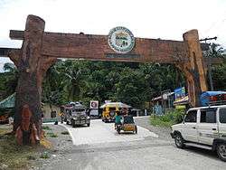
Landmarks
- Saint Nicolas of Tolentine Parish Church of Carranglan
- Carranglan Central School
- Carranglan Municipal Hall
Notable people of Carranglan
- Liza Soberano - Hope Elizabeth Soberano (formerly known by the screen name Hope Soberano), is a young Filipina American model and actress, a contract artist of ABS-CBN and Star Magic. She is currently starring in the teleserye FOREVERMORE and in the movie "THE BET" to be released in 2015. Her great grandmothers Isabel Jacinto Arevalo and Olympia Alnas Padilla were from Gapan and from Carranglan.
Gallery
.jpg) Spanish-built bridge in Carranglan
Spanish-built bridge in Carranglan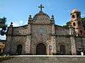 Saint Nicolas of Tolentine Parish Church
 Carranglan Municipal Hall
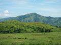 The mountains of Sierra Madre, located east of the municipality
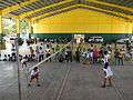 Carranglan's Gymnasium
 Legislative building
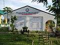 Nueva Ecija University of Science and Technology
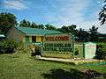 Carranglan Central School

References
- ↑ "Official City/Municipal 2013 Election Results". Intramuros, Manila, Philippines: Commission on Elections (COMELEC). 11 September 2013. Retrieved 21 October 2013.
- ↑ "Province: Nueva Ecija". PSGC Interactive. Makati City, Philippines: National Statistical Coordination Board. Archived from the original on 21 October 2013. Retrieved 21 October 2013.
- 1 2 "Total Population by Province, City, Municipality and Barangay: as of May 1, 2010" (PDF). 2010 Census of Population and Housing. National Statistics Office. Archived from the original (PDF) on 2012-11-15. Retrieved 2012-10-22.
- ↑ Census of Population (2015). "Region III (Central Luzon)". Total Population by Province, City, Municipality and Barangay. PSA. Retrieved 20 June 2016.
- ↑ Census of Population and Housing (2010). "Region III (Central Luzon)". Total Population by Province, City, Municipality and Barangay. NSO. Retrieved 29 June 2016.
- ↑ Census of Population (1995, 2000 and 2007). "Region III (Central Luzon)". Total Population by Province, City and Municipality. NSO. Archived from the original on 24 June 2011.
- ↑ "Province of Nueva Ecija". Municipality Population Data. Local Water Utilities Administration Research Division. Retrieved 17 December 2016.
External links
| Wikimedia Commons has media related to Carranglan, Nueva Ecija. |
- Philippine Standard Geographic Code
- Philippine Census Information
- Local Governance Performance Management System
| Adjacent places of Carranglan, Nueva Ecija | ||||
|---|---|---|---|---|
 |
San Nicolas, Pangasinan | Santa Fe / Aritao, Nueva Vizcaya | | |
| Natividad, Pangasinan San Quintin, Pangasinan |
|
Dupax del Sur, Nueva Vizcaya | ||
| ||||
| | ||||
| Umingan, Pangasinan Lupao |
San Jose | Pantabangan | ||
Palayan (capital) | |
| Municipalities | |
| Component cities | |
| Misc. | |
This article is issued from
Wikipedia.
The text is licensed under Creative Commons - Attribution - Sharealike.
Additional terms may apply for the media files.