Carraízo Dam
| Carraízo Dam | |
|---|---|
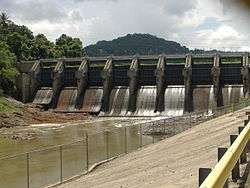 Carraízo Dam in 2007 | |
 Location of Carraízo Dam in Puerto Rico | |
| Official name | Carraízo Dam |
| Location | Trujillo Alto, Puerto Rico |
| Coordinates | 18°19′40″N 66°00′57″W / 18.32778°N 66.01583°WCoordinates: 18°19′40″N 66°00′57″W / 18.32778°N 66.01583°W |
| Purpose | Water storage, recreation |
| Status | Operational |
| Opening date | 1953 |
| Construction cost | $60 million |
| Owner(s) | Puerto Rico Aqueducts and Sewers Authority |
| Dam and spillways | |
| Type of dam | Concrete gravity |
| Impounds | Río Grande de Loíza |
| Height | 144 ft (44 m) |
| Length | 690 ft (210 m) |
| Width (crest) | 45 ft (14 m) |
| Width (base) | 98 ft (30 m) |
| Dam volume | 35,100,000 cu yd (26,800,000 m3) |
| Reservoir | |
| Creates | Loíza Lake |
|
Website Carraízo | |
Carraízo Dam is a concrete gravity dam located in the municipality of Trujillo Alto, Puerto Rico within the flow of the Río Grande de Loíza. Its construction was completed in 1953. Carraízo Dam impounds Loíza Lake which serves as Puerto Rico's main water reservoir.
Background and construction
At the end of the 1940s, the Puerto Rico Aqueducts and Sewers Authority proposed the construction of a dam at the Río Grande de Loíza in the Barrio Carraízo of Trujillo Alto with the intention of providing both water and electricity to the San Juan Metropolitan Area.[1]
Construction of the dam began in 1950 and finished in 1954. As part of the construction, the dam included three hydroelectric turbines with a total capacity of 3 Megawatts for the provision of electricity. However, during the 1960s and 1970s, the turbines were shut down because their operation and maintenance wasn't considered cost-effective versus the cost of buying energy at the time.[2]
Operation
Carraízo dam is a concrete gravity dam. It features eight floodgates along its 690-foot (210-meter) body. The floodgates open at a height of 3 feet 3 inches to 32 feet 10 inches (1 to 10 meters), but they are usually opened at 13 feet (4 meters). The reservoir created by the Carraízo Dam is the Loíza Lake. Carraízo's water storage capacity is of 4,650,000 gallons, and 135.0 feet (41.15 meters) is its peak level.[2]
References
- ↑ "División de Educación Continua y Estudios Avanzados: Trujillo Alto" (PDF). University of Puerto Rico, Carolina. Retrieved February 16, 2013.
- 1 2 Lázaro, Alberto (February 15, 2012). "Comentarios a R de la C 1966" (PDF). Office of Legislative Services. Archived from the original (PDF) on 2016-03-03.
External links
- Carraízo Dam on ProyectoSalonHogar
- USGS Lago Loíza at Damsite - 50059000
- - Carraízo Dam Water Level