Carolina, Alabama
| Carolina, Alabama | |
|---|---|
| Town | |
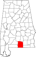
 Location of Carolina in Covington County, Alabama. | |
| Coordinates: 31°13′53″N 86°31′14″W / 31.23139°N 86.52056°W | |
| Country | United States |
| State | Alabama |
| County | Covington |
| Area[1] | |
| • Total | 1.12 sq mi (2.89 km2) |
| • Land | 1.11 sq mi (2.87 km2) |
| • Water | 0.01 sq mi (0.02 km2) |
| Elevation | 328 ft (100 m) |
| Population (2010) | |
| • Total | 297 |
| • Estimate (2016)[2] | 296 |
| • Density | 266.91/sq mi (103.08/km2) |
| Time zone | Central (CST) (UTC-6) |
| • Summer (DST) | CDT (UTC-5) |
| FIPS code | 01-12160 |
| GNIS feature ID | 0159327 |
Carolina is a town in Covington County, Alabama, United States. It is located about 95 miles (153 km) south of Montgomery and about 80 miles (130 km) west of Dothan. At the 2010 census the population was 297.[3]
Geography
Carolina is located west of the center of Covington County at 31°13′53″N 86°31′14″W / 31.23139°N 86.52056°W (31.231521, -86.520607).[4] According to the U.S. Census Bureau, the town has a total area of 1.1 square miles (2.9 km2), of which 0.008 square miles (0.02 km2), or 0.71%, is water.[3]
Demographics
| Historical population | |||
|---|---|---|---|
| Census | Pop. | %± | |
| 1970 | 192 | — | |
| 1980 | 203 | 5.7% | |
| 1990 | 201 | −1.0% | |
| 2000 | 248 | 23.4% | |
| 2010 | 297 | 19.8% | |
| Est. 2016 | 296 | [2] | −0.3% |
| U.S. Decennial Census[5] 2013 Estimate[6] | |||
As of the census[7] of 2010, there were 297 people, 101 households, and 75 families residing in the town. The population density was 221.0 people per square mile (85.5/km2). There were 118 housing units at an average density of 105.2 per square mile (40.7/km2). The racial makeup of the town was 99.60% White and 0.40% Black or African American. 0.40% of the population were Hispanic or Latino of any race.
There were 101 households out of which 31.7% had children under the age of 18 living with them, 66.3% were married couples living together, 6.9% had a female householder with no husband present, and 25.7% were non-families. 22.8% of all households were made up of individuals and 5.9% had someone living alone who was 65 years of age or older. The average household size was 2.46 and the average family size was 2.89.
In the town, the population was spread out with 26.6% under the age of 18, 8.5% from 18 to 24, 26.6% from 25 to 44, 21.8% from 45 to 64, and 16.5% who were 65 years of age or older. The median age was 35 years. For every 100 females there were 98.4 males. For every 100 females age 18 and over, there were 102.2 males.
The median income for a household in the town was $33,750, and the median income for a family was $37,708. Males had a median income of $26,250 versus $16,750 for females. The per capita income for the town was $13,491. About 12.7% of families and 10.4% of the population were below the poverty line, including 15.5% of those under the age of eighteen and 15.4% of those sixty five or over.
History
Carolina was founded by Elzy Henderson Garvin from Wagoner, South Carolina. South Carolina had been hit by an especially severe drought and the Latter Day Saint (Mormons) Missionaries, began preaching in South Carolina. Many of the Garvin family, converted to the Mormon faith. He left South Carolina in search of better land, better climate for farming and for matters of faith. It was recorded that he once remarked, "Our family left Ireland to practice our faith, and we are not becoming something new." The area reminded him so much of his home state that he named it "Carolina". Elzy was married to Emma Catherine Bass. They produced 5 children. Sherman, Ollie, Nancy, Willia & Odessa. Elzy and Emma are both buried in Carolina, Al. Many of his relations have been found to be buried at Bethcar Baptist Church on the outskirts of Wagoner, SC.
References
- ↑ "2016 U.S. Gazetteer Files". United States Census Bureau. Retrieved Jul 17, 2017.
- 1 2 "Population and Housing Unit Estimates". Retrieved June 9, 2017.
- 1 2 "Geographic Identifiers: 2010 Demographic Profile Data (G001): Carolina town, Alabama". U.S. Census Bureau, American Factfinder. Retrieved June 10, 2014.
- ↑ "US Gazetteer files: 2010, 2000, and 1990". United States Census Bureau. 2011-02-12. Retrieved 2011-04-23.
- ↑ "U.S. Decennial Census". Census.gov. Archived from the original on May 12, 2015. Retrieved June 6, 2013.
- ↑ "Annual Estimates of the Resident Population: April 1, 2010 to July 1, 2013". Retrieved June 3, 2014.
- ↑ "American FactFinder". United States Census Bureau. Archived from the original on 2013-09-11. Retrieved 2008-01-31.
Coordinates: 31°13′53″N 86°31′14″W / 31.231521°N 86.520607°W
