Marigot, Saint Martin
| Marigot | |
|---|---|
|
Marigot | |
 Marigot | |
| Coordinates: 18°04′23″N 63°04′56″W / 18.0731°N 63.0822°WCoordinates: 18°04′23″N 63°04′56″W / 18.0731°N 63.0822°W | |
| Country | France |
| Overseas collectivity | Saint Martin |
| Population (2006) | |
| • Total | 5,700 |
Marigot is the main town and capital in the French Collectivity of Saint Martin.
Population
As of 2017, it has 12000 inhabitants.
Geography
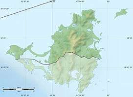
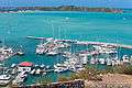
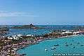
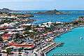
Marigot is located on the west coast of the island of St. Martin. It extends from the coast to the west, along the Bay of Marigot and the hills of the interior of the island to the east. On the south-west it is bounded by the Simpson Bay.
Climate
This area typically has a pronounced dry season. According to the Köppen Climate Classification system, Marigot has a tropical savanna climate, abbreviated "Aw" on climate maps.[1]
| Climate data for Marigot | |||||||||||||
|---|---|---|---|---|---|---|---|---|---|---|---|---|---|
| Month | Jan | Feb | Mar | Apr | May | Jun | Jul | Aug | Sep | Oct | Nov | Dec | Year |
| Average high °C (°F) | 28 (83) |
28 (83) |
28 (83) |
29 (84) |
30 (86) |
31 (88) |
31 (88) |
31 (88) |
31 (88) |
31 (87) |
29 (85) |
28 (83) |
30 (86) |
| Average low °C (°F) | 24 (75) |
24 (75) |
24 (75) |
25 (77) |
26 (78) |
27 (80) |
27 (80) |
27 (80) |
27 (80) |
27 (80) |
26 (78) |
24 (76) |
26 (78) |
| Average precipitation mm (inches) | 74 (2.9) |
48 (1.9) |
43 (1.7) |
79 (3.1) |
99 (3.9) |
71 (2.8) |
84 (3.3) |
114 (4.5) |
117 (4.6) |
99 (3.9) |
117 (4.6) |
91 (3.6) |
1,021 (40.2) |
| Source: Weatherbase [2] | |||||||||||||
Transport
 | |
 Saint Martin | |
| Location |
Marigot Collectivity of Saint Martin |
|---|---|
| Coordinates | 18°04′15.8″N 63°05′11.5″W / 18.071056°N 63.086528°W |
| Construction | masonry tower |
| Tower shape | cylindrical frustum tower with light |
| Markings / pattern | white tower |
| Height | 10 metres (33 ft) |
| Focal height | 20 metres (66 ft) |
| Light source | solar power |
| Range |
white: 11 nautical miles (20 km; 13 mi) red: 7 nautical miles (13 km; 8.1 mi) green: 7 nautical miles (13 km; 8.1 mi) |
| Characteristic | Fl WRG 4s. |
| Admiralty number | J5658 |
| NGA number | 14732 |
| ARLHS number | STM-001[3][4] |
The city is served by Princess Juliana International Airport as well as L'Espérance Airport. There is a ferry to Blowing Point, Anguilla.
History and features
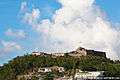
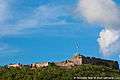
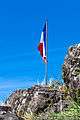
Originally a fishing village on a swamp for which it was named, Marigot was made capital during the reign of King Louis XVI, who built Fort St. Louis on a hill near Marigot Bay. Today, that building is the most important in Marigot.


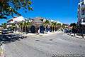
Marigot is typical of Caribbean towns, with gingerbread houses and sidewalk bistros. Market days are every Wednesday and Saturday morning. The crew of the 1998 in film motion picture Speed 2 shot the finale scene here where the Seabourn Legend hits the island.
Gallery


See also
References
- ↑ "Marigot, Saint Martin Köppen Climate Classification (Weatherbase)". Weatherbase.
- ↑ "Weatherbase: Historical Weather for The Valley, Anguilla". Weatherbase. 2011. Retrieved on November 24, 2011.
- ↑ San Martin The Lighthouse Directory. University of North Carolina at Chapel Hill. Retrieved 27 January 2017
- ↑ List of Lights, Pub. 110: Greenland, The East Coasts of North and South America (Excluding Continental U.S.A. Except the East Coast of Florida) and the West Indies (PDF). List of Lights. United States National Geospatial-Intelligence Agency. 2016.
External links
| Wikimedia Commons has media related to Marigot. |
- Saint Martin Tourist Guide
- www.geographia.com, St Martin