Camber Railway
| Camber Railway | |
|---|---|
|
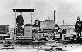
One of the two 'Wren' class narrow gauge steam locomotives of Camber Railway on the Falkland Islands, 1915. The open cab was not appropriate for a Falklands winter. This photo was probably taken immediately after the unloading of the locomotive in 1915, with the ship in the background being the SS Ismailia which brought the railway and wireless station equipment out from Britain. The picture illustrates the two original types of wagon, a tipper on an inside bearing oval chassis seen on the left, and a flat wagon on a rectagular outside bearing chassis seen to the right. Both types of wagon ran on coil springs. | |
| Overview | |
| Type | Narrow gauge railway |
| Locale | Stanley, Falkland Islands |
| Termini |
Stanley Harbour Admiralty wireless station |
| Stations | none |
| Operation | |
| Opened | 1915[1] |
| Closed | 1920 / 1940[1] |
| Rolling stock | 2 locomotives and 3 cars[1] |
| Technical | |
| Line length | 5.6 km (3.5 mi) |
| Number of tracks | Single track |
| Track gauge | 2 ft (610 mm)[1] |
The Camber Railway was a 2 ft (610 mm) narrow gauge railway in the Falkland Islands, in the South Atlantic; it was one of the most southerly railways in the world. The Camber Railway was constructed to support the Admiralty wireless station, supplying coal to generators; it ran along the north side of Stanley Harbour for about 3.5 miles (5.6 km).[2][1]
History
There were two Kerr, Stuart and Company "Wren" class 0-4-0 engines.[2][1] The system fell into disuse after the wireless station was modernised. Parts of the infrastructure were used in the Falklands War; rails were taken for use in some defensive structures.[1]
Fleet
- KS "Wren" class steam locomotives - 2 (KS 2388/15 and 2392/15)
- wooden wagon cars - 3
- steam crane (on flar car) - 1
- tipper wagon
- flat car wagon
Gallery
|
References
External links
| Wikimedia Commons has media related to Camber Railway. |
- The Camber Railway, Falkland Islands - Britlink
- Railways of the Far South: Falkland Islands and Camber Railway
- (in Spanish) Historias poco conocidas: Un ferrocarril en las Malvinas
Coordinates: 51°40′58″S 57°53′03″W / 51.6828°S 57.8842°W
This article is issued from
Wikipedia.
The text is licensed under Creative Commons - Attribution - Sharealike.
Additional terms may apply for the media files.


