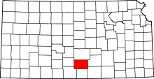
Calista, Kansas
Calista is an unincorporated community in Kingman County, Kansas, United States. It was named from the Greek Callista, meaning "most beautiful".[1]
History
Calista became a town in 1886 after the town of Maud (1881-1886) was moved there.[2] This original town known as "Old Calista" lasted until 1896[3] when the town had to be moved to make way for the Atchison, Topeka and Santa Fe Railway.[4][5] "New" Calista was founded about two miles west-southwest of "Old" Calista[6] and was a town until 1955.[7] Now Calista is a ghost town with only a few buildings remaining and a small grain elevator open for about two weeks a year during the wheat harvest.[8]
Geography
Calista is located in southern Kansas about nine miles west of the city of Kingman and is near the south bank of the Ninnescah River.[9][10]
References
- ↑ "Profile for Calista, Kansas". ePodunk. Retrieved 12 June 2014.
- ↑ "Kansas Post Offices, 1828-1961: Kingman County". www.kshs.org. Kansas State Historical Society. Archived from the original on 9 October 2013. Retrieved 23 April 2015.
- ↑ "Kansas Post Offices, 1828-1961: Kingman County". www.kshs.org. Kansas State Historical Society. Archived from the original on 9 October 2013. Retrieved 23 April 2015.
- ↑ "Historical Directory of Kansas Towns [C]". http://www.kansastowns.us/. Retrieved 23 April 2015. External link in
|website=(help) - ↑ Standard Atlas of Kingman County Kansas. Chicago: Geo. A. Ogle & Co. 1921. p. 13. Retrieved 23 April 2015.
- ↑ "Historical Directory of Kansas Towns [C]". http://www.kansastowns.us/. Retrieved 23 April 2015. External link in
|website=(help) - ↑ "Kansas Post Offices, 1828-1961: Kingman County". www.kshs.org. Kansas State Historical Society. Archived from the original on 9 October 2013. Retrieved 23 April 2015.
- ↑ "Historical Directory of Kansas Towns [C]". http://www.kansastowns.us/. Retrieved 23 April 2015. External link in
|website=(help) - ↑ Standard Atlas of Kingman County Kansas. Chicago: Geo. A. Ogle & Co. 1921. p. 5. Retrieved 23 April 2015.
- ↑ "Historical Directory of Kansas Towns [C]". http://www.kansastowns.us/. Retrieved 23 April 2015. External link in
|website=(help)
Coordinates: 37°38′23″N 98°16′57″W / 37.63972°N 98.28250°W
