California State Route 262
| ||||
|---|---|---|---|---|
| Mission Boulevard | ||||
|
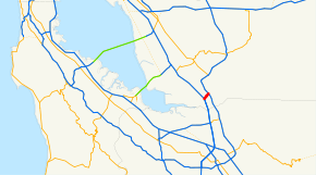
SR 262 highlighted in red | ||||
| Route information | ||||
| Defined by Streets and Highways Code § 562 | ||||
| Maintained by Caltrans | ||||
| Length: | 1.070 mi[1] (1.722 km) | |||
| Major junctions | ||||
| South end: |
| |||
| North end: |
| |||
| Location | ||||
| Counties: | Alameda | |||
| Highway system | ||||
| ||||

State Route 262 (SR 262) is a state highway in the U.S. state of California. More commonly known as Mission Boulevard, SR 262 is a very short state highway that connects two Interstate highways in the San Francisco Bay Area.
Route description
SR 262 begins at its western interchange with Interstate 880 in Fremont. It travels 1-mile (1.6 km) east to its terminus and junction with Interstate 680 in Fremont. SR 262 was built solely to be a link between the two interstates and lies at the point that Interstates 880 and 680 are closest together in the East Bay. 2 miles (3.2 km) north of SR 262, I-680 abruptly turns to the Northeast and into the Sunol and Livermore Valley thus making SR 262 a vital link between those valleys and the Silicon Valley to the south.
Physically SR 262 begins as a 4 lane road that has been build to freeway standards for its first half miles and after intersecting Kato Road and Warren Avenue with separated grade intersections built in 2008 and 2015, respectively. The remaining half mile is a 4-6 lane city street with two traffic lights at Warm Springs Blvd and Mohave Drive before terminating at a cloverleaf interchange at I-680.
SR 262 is unsigned along its entire route and would be unnoticeable to the public if not for two guide signs placed in the early 2000s on south I-680 that designate the exit as "SR 262 to I-880 Mission Blvd". There is no other signage on I-880 that designates the road by its route number. Signage for the southbound I-680 toll express lane, opened in September 2010, indicates an exit at "262 - Mission Blvd." Locals are largely unaware of the route designation and refer to the road as Mission Blvd exclusively.
History
Originally SR 262 was originally slated to run the route of present day Oakland Road from San Jose to where present day Warm Springs Blvd and Mission Blvd intersect. This plan was scrapped when State Route 17 (later I-880) was constructed. SR 262 was subsequently routed along its present route.
One planning option was for SR 262 to be deleted from the state route list when State Route 237 to the south was completed between I-880 and I-680. However there is no longer room between the developed areas to build 237 into a freeway there.
SR 262 is also a signed section of the Juan Bautista De Anza National Historic Trail.
Major intersections
Except where prefixed with a letter, postmiles were measured on the road as it was in 1964, based on the alignment that existed at the time, and do not necessarily reflect current mileage. R reflects a realignment in the route since then, M indicates a second realignment, L refers an overlap due to a correction or change, and T indicates postmiles classified as temporary (for a full list of prefixes, see the list of postmile definitions).[1] Segments that remain unconstructed or have been relinquished to local control may be omitted. The entire route is in Fremont, Alameda County.
| Postmile [1][2][3] | Exit | Destinations | Notes | ||
|---|---|---|---|---|---|
| R0.00 | Southbound exit and northbound entrance; south end of SR 262 | ||||
| | Gateway Boulevard | Closed; former southbound exit and entrance | |||
| R0.39 | 1 | Kato Road | Southbound exit and northbound entrance, opened in 2015 | ||
| | North end of freeway | ||||
| R0.70 | Warm Springs Boulevard – Irvington District, Warm Springs District | ||||
| R1.07 | Interchange; north end of SR 262 | ||||
| R1.07 | Mission Boulevard | Continuation beyond I-680; former SR 21 north | |||
1.000 mi = 1.609 km; 1.000 km = 0.621 mi
| |||||
See also
 California Roads portal
References
- 1 2 3 California Department of Transportation. "State Truck Route List". Sacramento: California Department of Transportation. Archived from the original (XLS file) on June 30, 2015. Retrieved June 30, 2015.
- ↑ California Department of Transportation, Log of Bridges on State Highways, July 2007
- ↑ California Department of Transportation, All Traffic Volumes on CSHS, 2005 and 2006
External links
Route map: Google
| Wikimedia Commons has media related to California State Route 262. |
- California @ AARoads.com - State Route 262
- Caltrans: Route 262 highway conditions
- California Highways: SR 262

