Cabauw
| Cabauw | |
|---|---|
| Village | |
|
Houses and Jacobus Church in Cabauw | |
 | |
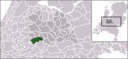
 The village centre (dark green) and the statistical district (light green) of Cabauw in the municipality of Lopik. | |
| Coordinates: 51°57′52″N 4°53′54″E / 51.96444°N 4.89833°ECoordinates: 51°57′52″N 4°53′54″E / 51.96444°N 4.89833°E | |
| Country | Netherlands |
| Province | Utrecht (province) |
| Municipality | Lopik |
| Population (2004) | |
| • Total | 690 |
| Time zone | CET (UTC+1) |
| • Summer (DST) | CEST (UTC+2) |
Cabauw is a village in the Dutch province of Utrecht. It is a part of the municipality of Lopik, and lies about 12 km southwest of IJsselstein. Cabauw consists of a small village centre, and a ribbon of farms along the Lopiker Wetering, between Zevender and Lopik.
In 2008, the village centre of Cabauw had 310 inhabitants. The built-up area of the village was 0.05 km², and contained 123 residences.[1] The statistical district Cabauw, covering the village centre and the farms along the canal, has a population of around 690.[2]
Cabauw used to be a separate municipality. In 1857, it became a part of the municipality of Willige Langerak, which in its turn was merged into Lopik in 1943.
References
- ↑ Statistics Netherlands (CBS), Bevolkingskernen in Nederland 2001 . Statistics are for the continuous built-up area.
- ↑ Statistics Netherlands (CBS), Gemeente Op Maat 2004: Lopik .
This article is issued from
Wikipedia.
The text is licensed under Creative Commons - Attribution - Sharealike.
Additional terms may apply for the media files.
