Cañada Garcia Creek
| Cañada Garcia Creek | |
| stream | |
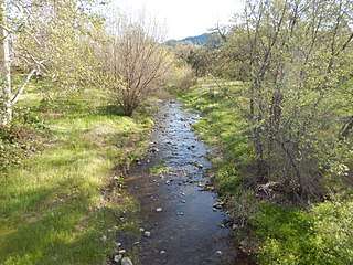 Cañada Garcia Creek along Uvas Road in Llagas-Uvas, California. | |
| Country | United States |
|---|---|
| State | California |
| Region | Santa Clara County |
| City | Morgan Hill, California |
| Source | On the southern flank of Portezuelo Gap near Manzanita Ridge in the eastern foothills of the Santa Cruz Mountains[1][2] |
| - elevation | 1,080 ft (329 m) |
| - coordinates | 37°08′12″N 121°45′53″W / 37.13667°N 121.76472°W [3] |
| Mouth | Confluence with Llagas Creek |
| - elevation | 530 ft (162 m) [3] |
| - coordinates | 37°07′27″N 121°44′00″W / 37.12417°N 121.73333°WCoordinates: 37°07′27″N 121°44′00″W / 37.12417°N 121.73333°W [3] |
Cañada Garcia Creek is a perennial stream in southwest Santa Clara County, California, United States.[4] The headwaters rise on the southern flank of Portezelo Gap near Manzanita Ridge in the eastern foothills of the Santa Cruz Mountains. From there, the creek flows southeastward, eventually merging with Llagas Creek.
See also
References
- ↑ "Portezuelo Gap". Geographic Names Information System. United States Geological Survey.
- ↑ "Manzanita Ridge". Geographic Names Information System. United States Geological Survey.
- 1 2 3 "Cañada Garcia Creek". Geographic Names Information System. United States Geological Survey.
- ↑ Santa Clara Valley Water District
External links
- "Llagas Creek Watershed Tour". Retrieved 2017-08-11.
This article is issued from
Wikipedia.
The text is licensed under Creative Commons - Attribution - Sharealike.
Additional terms may apply for the media files.