Manila–Cavite Expressway
CAVITEx | |
|---|---|
|
Coastal Road Aguinaldo Boulevard Manila — Cavite Coastal Road | |
| Route information | |
| Length: | 14.0 km (8.7 mi) |
| Existed: | 1998[1] – present |
| Component highways: |
|
| Major junctions | |
| North end: |
|
| |
| South end: |
|
| Location | |
| Major cities: | |
| Towns: | Kawit |
| Highway system | |
|
Roads in the Philippines | |
.svg.png)
The Manila–Cavite Expressway, also known as Coastal Road/CAVITEx, is a 14-kilometre-long (8.7 mi) limited-access toll expressway linking Manila to the southern province of Cavite in the Philippines. It is designated as Expressway 3 (E3) of the Philippine expressway network and a component of Radial Road 1 (R-1) of Manila's arterial road network. It is owned and operated by the Public Estates Authority Tollway Corporation (PEATC), a government-owned and controlled corporation and a subsidiary of the Public Estates Authority, an office under the Office of the President.
At the north end, it feeds into and from Roxas Boulevard in the city of Parañaque in Metro Manila, also part of R-1. At the south end, it splits into two terminii, both along the north coast in Kawit, Cavite. One feeds into the intersection of Tirona Highway and Antero Soriano Highway. Left backtracks through Binakayan back to Bacoor, straight proceeds on Soriano towards the Cavite Economic Zone, and right proceeds towards the highway's other terminus on Tirona Highway near the Aguinaldo Shrine heading towards Noveleta.
In 2011, the extension going to Kawit was opened to the public, where it will eventually connect to C-6, the now-under-construction Bulacan-Rizal-Manila-Cavite Regional Expressway and to the proposed Cavite–Laguna Expressway. In 2015, the C-5 Road was extended south to connect to the northbound lanes of the expressway in Las Piñas. Since December 2016, Coastal Road also links to the elevated NAIA Expressway at its north end providing access to the Ninoy Aquino International Airport and the Skyway. It will be the street alignment of the Manila LRT-1 South Extension when completed in Parañaque. It will have 2 stations, namely: Asia World and Ninoy Aquino International Airport.
The expressway features a limited number of interchanges. The original south terminus of the expressway in Bacoor has been converted into a full trumpet interchange. There are two toll barriers on the expressway: the original barrier at Las Piñas and the extension barrier in Kawit. Vehicles are charged a flat toll rate based on class. PEATC has also incorporated a near-field communication prepaid card it calls E-TAP. The Expressway is now also accepting an electronic toll collection system called Easydrive set up by Easytrip Serivices Corporation, which currently manages ETC for the North Luzon Expressway (however, Easydrive is currently not cross-compatible with the NLEX's Easytrip).[2]
Route description

_extension_(Zapote%2C_Bacoor%2C_Cavite%3B_2017-04-03)_(cropped).jpg)
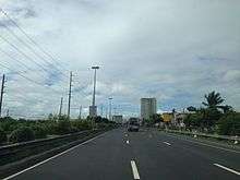
The Manila - Cavite Expressway mostly follows a curving route on the shores of Manila Bay, and the Bacoor- Kawit extension is built on reclaimed land near coastal barangays of Bacoor. The road is tolled using a barrier toll system, which involves toll barriers at entry points and no toll collection at the exit points, except in the Kawit end. The expressway is not fully grade separated, as a traffic light intersection exists in the middle of the NAIA Road - Zapote toll barrier segment. The expressway is a physical extension of Roxas Boulevard. Electric power transmission and subtransmission lines, operated and maintained by the National Grid Corporation of the Philippines (NGCP) and Meralco, respectively, line the expressway on its original route between NAIA Road and Bacoor. Lane count is usually 3 lanes for the NAIA Road - Bacoor section, that constitute the original route of the expressway usually nicknamed "Coastal Road", and 2 lanes at the Bacoor - Kawit segment, that forms the Kawit extension of the expressway.
The expressway starts at the traffic light intersection with NAIA Road and Roxas Boulevard, near Uniwide Coastal Mall. Past the intersection is an eastbound entrance and westbound exit of NAIA Expressway, opened in 2016. A Caltex gas station lies past Uniwide Coastal Mall and the NAIA Expressway interchange. The only at-grade intersection of the expressway comes before the Zapote toll barrier. An entry point from the "Kabihasnan" area of Parañaque is found before the approach to the Zapote toll plaza. The expressway widens on approach to the Zapote toll plaza, where tolls for motorists from Manila are collected. After Zapote toll plaza is a right-in/right-out interchange with the Circumferential Road 5 (C-5) extension, which are only accessible from the northbound direction. The expressway then passes Bacoor Exit, the original end of the expressway at Bacoor, where the original alignment involved a curve that was changed to a full interchange with the opening of the Kawit extension. CAVITEX past Zapote Exit becomes a four lane dual carriageway on reclaimed land built on the shores of seaside barangays of Bacoor. The expressway widens at approach to the Kawit toll plaza, where the end of the expressway is moved from the opening of the Kawit extension in 2010. The terminus at Kawit is an box intersection with Tirona Highway (N62) and Antero Soriano Highway (N64), with the latter being the physical extension of the existing expressway. The end of the expressway at Kawit will accommodate the Cavite end of the planned Cavite-Laguna Expressway.
History
Originally conceived as one of 3 expressways emanating from Manila, Coastal Road is proposed since the Marcos era, however, it was not constructed. Manila-Cavite Expressway started as a 6.6-kilometer (4.1 mi) expressway built on reclaimed land in 1998. [1] On 2011, a 7-kilometer (4.3 mi) extension to Kawit, Cavite, is opened.[1]
On December 28, 2016, the access ramps connecting Coastal Road and NAIA Expressway has been opened to all motorists coming from Cavite and Las Piñas City for easier access to NAIA Terminals 1, 2 and 3 and vice versa.
Future
CAVITEx - C5 South Link
CAVITEx - C5 South Link Expressway is a 7.7-kilometer, six-lane road which will connect C-5 road from Taguig to Coastal Road. It entails the construction of a flyover between the C-5 Road in Bicutan, Taguig and the C-5 Road extension in Merville, Parañaque over the South Luzon Expressway. The second phase includes the completion of the C-5 Road extension from Merville to Las Piñas and the construction of an interchange with Coastal Road. The ₱9.5B Cavitex C5 South Link project is expected to be completed by 2020.[3]
Technical specifications
- Name: Manila–Cavite Expressway or CAVITEX
- Concession holder: Cavite Infrastructure Corporation
- Operator: Cavite Infrastructure Corporation
- Concession starting date: 1996
- Concession ending date: 2023
- Length: 14 km
- Highway exits: 3
- Lanes: 4 Lanes (2 Lanes each direction)
- Toll plazas: 2
- Rest and Service Areas: none
- Minimum Height Clearance on Underpasses:
Toll

The expressway uses a barrier toll system that uses toll barriers at entry points, where motorists pay a fixed toll rate. Two large toll plazas and the Kabihasnan entry are the toll collection points for the expressway. The electronic toll collection (ETC) system on the expressway uses devices branded E-Tap or Easydrive, and collection are done on both dedicated lanes and mixed lanes at the toll barriers.
Tolls are assessed in each direction at each barrier, based on class. In accordance with law, all toll rates include a 12% Value-Added Tax.
| Class | Kabihasnan | Las Pinas | Kawit |
|---|---|---|---|
| 1 | ₱8.00 | ₱24.00 | ₱64.00 |
| 2 | N/A | ₱48.00 | ₱129.00 |
| 3 | N/A | ₱72.00 | ₱194.00 |
Exits
Current exits
This exit list includes all exits, and also exits under construction.
| Region | Province | City/Municipality | km | mi | Exit | Name | Destinations | Notes |
|---|---|---|---|---|---|---|---|---|
| Metro Manila | Parañaque | 8 | 5.0 | NAIA Road | Start of expressway. Road continues as Roxas Boulevard going to Manila. | |||
| 8.3 | 5.2 | NAIA Expressway | Northbound exit and southbound entrance. | |||||
| 10 | 6.2 | Diosdado Macapagal Boulevard | Traffic light intersection. No right turns from southbound lane. For conversion to interchange. | |||||
| Las Piñas | 13 | 8.1 | C5 South Link Interchange | Proposed interchange | ||||
| Las Piñas Toll Plaza | ||||||||
| 14 | 8.7 | C-5 Road Extension | Incomplete right-in/right-out exit for C-5 Road Extension. Entrance only. | |||||
| Calabarzon | Cavite | Bacoor | 15 | 9.3 | Zapote | Las Piñas, Bacoor | ||
| Kawit | 23 | 14 | Kawit Toll Plaza | |||||
| 24 | 15 | Kawit, Naic | At-grade intersection. End of expressway. Road continues south as Antero Soriano Highway. Link with the future, Cavite-Laguna Expressway. | |||||
1.000 mi = 1.609 km; 1.000 km = 0.621 mi
| ||||||||
Future Exits
| Kilometer No. | Exit | Interchange type | Location | Remarks |
|---|---|---|---|---|
| TBA | CAVITEx-BRMCRex | TBA | Bacoor, Cavite | It connects Bulacan–Rizal–Manila–Cavite Regional Expressway and Cavitex |
| TBA | Sangley Point | TBA | Las Piñas, Manila | It connects Coastal Road to the Airport on Cavite City. This is an underwater road with Light Rail Transit.[4] |
References
- 1 2 3 "Land Development". Philippine Reclamation Authority. Retrieved 20 January 2016.
- ↑ "Frequently Asked Question - Cavitex". Easytrip Services Corporation Philippines. Retrieved 2016-12-27.
- ↑ Amojelar, D.G. (1 February 2017). "FF Cruz to build Cavitex C5 link". The Standard (Philippines). Retrieved 7 February 2017.
- ↑ http://www.ramboll.com/megatrend/feature-articles/gateway-asia-2030
External links
| Wikimedia Commons has media related to Manila–Cavite Expressway. |
| Operational | |
|---|---|
| Planned | |
| Under construction | |
See also: Philippine expressway network | |
Coordinates: 14°28′10″N 120°57′27″E / 14.46944°N 120.95750°E