Bunkyō
| Bunkyō 文京区 | ||
|---|---|---|
| Special ward | ||
| Bunkyō City | ||
|
Tokyo Dome | ||
| ||
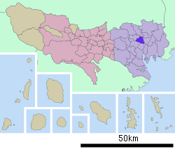
 Location of Bunkyō in Tokyo | ||
 Bunkyō Location in Japan | ||
| Coordinates: 35°43′N 139°45′E / 35.717°N 139.750°ECoordinates: 35°43′N 139°45′E / 35.717°N 139.750°E | ||
| Country | Japan | |
| Region | Kantō | |
| Prefecture | Tokyo | |
| Government | ||
| • Mayor | Hironobu Narisawa | |
| Area | ||
| • Total | 11.29 km2 (4.36 sq mi) | |
| Population (May 1, 2015) | ||
| • Total | 217,743 | |
| • Density | 19,290/km2 (50,000/sq mi) | |
| Symbols | ||
| • Tree | Ginkgo biloba | |
| • Flower | Azalea | |
| Time zone | Japan Standard Time (UTC+9) | |
| City hall address |
Kasuga 1-16-21, Bunkyo-ku, Tokyo 112-6555 | |
| Website |
www | |
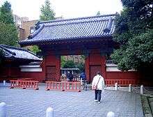
Bunkyō (文京区 Bunkyō-ku) is a special ward located in Tokyo, Japan. Situated in the middle of the ward area, Bunkyō is a residential and educational center. Beginning in the Meiji period, literati like Natsume Sōseki, as well as scholars and politicians have lived there. Bunkyō is home to the Tokyo Dome, judo's Kodokan, and the University of Tokyo (Hongo Campus). The English translation of its Japanese self-designation is Bunkyō City. Bunkyō has a sister-city relationship with Kaiserslautern in the Rhineland-Palatinate of Germany.[1]
As of May 1, 2015, the ward has a population of 217,743 (including about 6,500 foreign residents) and a population density of 19,290 persons per km². The total area is 11.29 km².
The ward was founded on March 15, 1947.
Geography
Districts
There are approximately twenty districts in the area and these are as follows:
- Hakusan
- Hongō
- Hon-komagome
- Kasuga
- Kohinata
- Koishikawa
- Kōraku
- Mejirodai
- Mukōgaoka
- Nezu
- Nishikata
- Otowa
- Ōtsuka
- Sekiguchi
- Sendagi
- Sengoku
- Suidō
- Yayoi
- Yushima
Politics and government
Bunkyo is governed by mayor Hironobu Narisawa, an independent supported by the Liberal Democratic Party, Democratic Party of Japan and Komeito.[2] The city council has 34 elected members.[3]
Economy
The publishing company Kodansha has its headquarters in the ward,[4] and Kodansha International has its headquarters in the Otowa YK Building in the ward.[5] The drugstore chain Tomod's has its headquarters in the ward.[6] Penta-Ocean, the construction firm specializing in marine works and land reclamation also has its headquarters in Bunkyo.[7]
Landmarks

- Chinzan-so Garden
- Denzū-in Temple
- Gokoku-ji Temple
- Harimasaka Sakura Colonnade
- Hatoyama Hall[8]
- Kisshō-ji
- Kodansha Noma Memorial Museum
- Kodokan Judo Institute
- Koishikawa Botanical Garden
- Koishikawa Kōrakuen
- Koishikawa Ukiyo-e Art Museum
- Nezu Shrine
- Nippon Medical School
- Orugoru no Chiisana Hakubutsukan
- Rikugien Garden
- Shin-Edogawa Garden
- Tokyo Cathedral (St. Mary's Cathedral)
- Tokyo Dome
- Tokyo Dome City
- Toshimagaoka Imperial Cemetery
- Toyo University
- Tōyō Bunko "Oriental Library", Japan's largest Asian studies library
- University of Tokyo
- Yanaka Cemetery
- Yayoi Museum
- Yushima Seidō
Education
Universities and colleges
National

- Ochanomizu University
- University of Tsukuba Ōtsuka Campus
- University of Tokyo Hongō Campus
- Tokyo Medical and Dental University
Private

- Atomi University
- Juntendo University
- Takushoku University
- Chuo University Engineering department
- Tokyo Woman's Christian University
- Toyo University
- Toyo Gakuen University
- Nippon Medical School
- Japan Women's University
- Bunkyo Gakuin University
- Bunkyo Gakuin College
- International College for Postgraduate Buddhist Studies
Primary and secondary schools
Public elementary and junior high schools are operated by Bunkyo council. Public high schools are operated by the Tokyo Metropolitan Government Board of Education.
The metropolis operates the Koishikawa Secondary Education School.[13]
The metropolis operates the Bunkyo School for the Blind.[14]
Transportation
Train stations
Toei subway lines
- Toei Mita Line: Sengoku, Hakusan, Kasuga, Suidōbashi
- Toei Ōedo Line: Iidabashi, Kasuga, Hongō Sanchōme
Tokyo Metro subway lines
- Tokyo Metro Chiyoda Line: Sendagi, Nezu, Yushima
- Tokyo Metro Marunouchi Line: Shin-Ōtsuka, Myōgadani, Kōrakuen, Hongō Sanchōme, Ochanomizu
- Tokyo Metro Yūrakuchō Line: Gokokuji, Edogawabashi
- Tokyo Metro Namboku Line: Kōrakuen, Tōdaimae, Honkomagome
Highways
- No.5 Ikebukuro Route (Takebashi JCT—Bijogi JCT)
References
- ↑ Bunkyo Academy Foundation. "Bunkyo Academy International exchanges". Retrieved 20 July 2011.
- ↑ SNS-FreeJapan (16 April 2011). "文京区候補者情報一覧 東京都統一地方選挙・候補者紹介サイト". Archived from the original on 21 April 2011. Retrieved 20 July 2011.
- ↑ Bunkyo City Government Office. "Bunkyo city Plot of city council.". Retrieved 20 July 2011.
- ↑ "Company Overview Archived 2011-04-26 at the Wayback Machine.." Kodansha. Retrieved on April 5, 2011. "Address: 12-21, Otowa 2-chome, Bunkyo-ku, Tokyo 112-8001, Japan"
- ↑ "Corporate Profile" Kodansha. Retrieved on April 1, 2011. "Address Otowa YK Building 1-17-14 Otowa, Bunkyo-ku, Tokyo 112-8652" map
- ↑ "Company Profile." Tomod's. Retrieved on May 19, 2009.
- ↑ "Corporate Data." Penta-Ocean. Retrieved on March 23, 2014.
- ↑ "55. Museum Review: Hatoyama Kaikan (Bunkyo-ku)," November 18, 2008.
- ↑ 東京都立工芸高等学校. "東京都立工芸高等学校". Kogei-h.metro.tokyo.jp. Retrieved 2012-06-26.
- ↑ "東京都立小石川高等学校・東京都立小石川中等教育学校". Koishikawa-h.metro.tokyo.jp. Retrieved 2012-06-26.
- ↑ http://www.mukogaoka-h.metro.tokyo.jp/
- ↑ "竹早高校 ウェブページ". Takehaya-h.metro.tokyo.jp. Retrieved 2012-06-26.
- ↑ "Archived copy". Archived from the original on 2007-11-14. Retrieved 2007-10-30.
- ↑ "東京都立文京盲学校のホームページ". Bunkyo-sb.metro.tokyo.jp. Retrieved 2012-06-26.
External links
| Wikimedia Commons has media related to Bunkyo, Tokyo. |
- Bunkyo City official website (in Japanese)
- Bunkyo City official website (in English)
 Tokyo/Bunkyo travel guide from Wikivoyage


