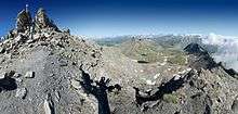
Bric Ghinivert
| Bric Ghinivert | |
|---|---|
| Eiminàl | |
|
| |
| Highest point | |
| Elevation | 3,037 m (9,964 ft) [1] |
| Prominence | 347 m (1,138 ft) [2][3] |
| Listing | Alpine mountains above 3000 m |
| Coordinates | 44°57′04.77″N 06°59′27.71″E / 44.9513250°N 6.9910306°ECoordinates: 44°57′04.77″N 06°59′27.71″E / 44.9513250°N 6.9910306°E |
| Geography | |
 Bric Ghinivert Alps | |
| Location | Piedmont, Italy |
| Parent range | Cottian Alps |
| Climbing | |
| Easiest route | Scrambling |
Bric Ghinivert or Eiminàl (3,037 m a.s.l.) is a mountain of the Cottian Alps located in Italy.
Geography
The mountain is the highest elevation of the water divide between Val Troncea (West) and Valle Germanasca (East). Following northwards the ridge Colle del Beth (Beth Pass, 2783 m a.s.l.) divides Bric Ghinivert from Bric di Mezzogiorno (2,986 m a.s.l.), while going South Colle di Ghinivert (2,831 m a.s.l.) separates it from Monte Peolioso (2,886 m a.s.l.).[3] Administratively the mountain is on the border between Pragelato and Massello municipalities (comuni).[3] On Bric Ghinivert top stands a summit cross.[4]
SOIUSA classification
According to SOIUSA (International Standardized Mountain Subdivision of the Alps) the mountain can be classified in the following way:[5]
- main part = Western Alps
- major sector = North Western Alps
- section = Cottian Alps
- subsection = Alpi del Monginevro
- supergroup = Catena Bucie-Grand Queyron-Orsiera
- group = Gruppo Queyron-Albergian-Sestrière
- subgroup = Sottogruppo Ghinivert-Albergian
- code = I/A-4.II-A.2.b
Nature conservation
The western face of the mountain belongs to the Parco naturale Val Troncea.[6]
Access to the summit

Easy routes to Bric Ghinivert start either from Val Troncea or from Val Germanasca; in both cases they does not require alpinistic skills[7] but some scrambling. In the italian scale of hiking difficulty is rated EE (Escursionisti Esperti, namely suitable for expert hikers).[4] A mountain hut managed by the nature Park is available for hikers on Colle del Beth previous arrangements with the park staff.[6]
History
Around the mountain are still identifiable remains of ancient copper mines and the connected miner's village. Aexplanatory boards created by the Nature Park outline the site history.[6]
See also
-
 Italy portal
 -
 Mountains portal
Notes
- ↑ Bric Ghinivert, Italy, web page on www.peakbagger.com (accessed on February 2017)
- ↑ Key col: Colle Valletta, 2690 m a.s.l.
- 1 2 3 Carta IGM 1:25.000 scale, see www.pcn.minambiente.it (access: February 2017)
- 1 2 user carusc (2011-04-07). "Ghinivert (Bric) da Pattemouche per il Colle del Beth". Retrieved 2017-02-15.
- ↑ Marazzi, Sergio (2005). Atlante Orografico delle Alpi. SOIUSA (in Italian). Priuli & Verlucca. ISBN 978-88-8068-273-8.
- 1 2 3 "Sentiero del Beth". Federparchi. Retrieved 2017-02-15.
- ↑ Ferreri, Eugenio (1982). Alpi Cozie Centrali. C.A.I. / T.C.I. pp. 225–226.
References
- Istituto Geografico Militare (IGM) official maps of Italy, 1:25,000 and 1:100,000 scale, on-line version
- Istituto Geografico Centrale - Carta dei sentieri e dei rifugi scala 1:50.000 n. 1 Valli di Susa, Chisone e Germanasca
- Istituto Geografico Centrale - Carta dei sentieri e dei rifugi scala 1:25.000 n.105 Sestriere, Claviere, San Sicario, Prali
External links
| Wikimedia Commons has media related to Bric Ghinivert. |