Brevard, North Carolina
| Brevard, North Carolina | |
|---|---|
| City | |
|
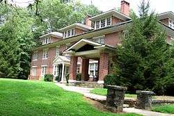
Ross Hall, Brevard College | |
|
Location of Brevard, North Carolina | |
| Coordinates: 35°14′30″N 82°43′43″W / 35.24167°N 82.72861°WCoordinates: 35°14′30″N 82°43′43″W / 35.24167°N 82.72861°W | |
| Country | United States |
| State | North Carolina |
| County | Transylvania |
| Government | |
| • Mayor | Jimmy Harris |
| Area | |
| • Total | 4.8 sq mi (12.5 km2) |
| • Land | 4.8 sq mi (12.4 km2) |
| • Water | 0.0 sq mi (0.0 km2) |
| Elevation | 2,231 ft (680 m) |
| Population (2010) | |
| • Total | 7,609 |
| • Estimate (2016)[1] | 7,822 |
| • Density | 1,600/sq mi (610/km2) |
| Time zone | Eastern (EST) (UTC-5) |
| • Summer (DST) | EDT (UTC-4) |
| ZIP code | 28712 |
| Area code(s) | 828 |
| FIPS code | 37-07720[2] |
| GNIS feature ID | 1009587[3] |
| Website |
www |
Brevard is a city in Transylvania County, North Carolina, United States, with a population of 7,609 as of the 2010 Census. It is the county seat of Transylvania County.[4]
Brevard is located at the entrance to Pisgah National Forest and has become a noted tourism, retirement and cultural center in western North Carolina. A moderate climate, environmental beauty and cultural activities attract relocators to the area.
Brevard is also known for its white squirrels. There are several theories of how they came to live there, including an overturned carnival truck and an escaped pet breeding with native squirrels.[5]
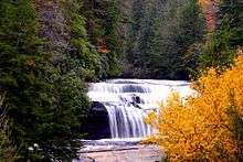
Brevard is also adjacent to DuPont State Forest, which is the only North Carolina State Forest designated as a recreational forest, and which attracted more than 650,000 visitors in 2015. A waterfall in the forest, Triple Falls, was used as a filming location for The Hunger Games.
Along with nearby Asheville and Hendersonville, Brevard forms the Asheville-Brevard, NC CSA combined statistical area.
Geography
According to the United States Census Bureau, the city has a total area of 5.12 square miles.[6] Of that 0.21% is water.
The area's many waterfalls have earned it the nickname,"The Land of Waterfalls." Some notable examples include Looking Glass Falls, Connestee Falls and Batson Creek Falls, and Sliding Rock.[7][8]
Demographics
| Historical population | |||
|---|---|---|---|
| Census | Pop. | %± | |
| 1880 | 223 | — | |
| 1890 | 327 | 46.6% | |
| 1900 | 584 | 78.6% | |
| 1910 | 919 | 57.4% | |
| 1920 | 1,658 | 80.4% | |
| 1930 | 2,339 | 41.1% | |
| 1940 | 3,061 | 30.9% | |
| 1950 | 3,908 | 27.7% | |
| 1960 | 4,857 | 24.3% | |
| 1970 | 5,243 | 7.9% | |
| 1980 | 5,323 | 1.5% | |
| 1990 | 5,388 | 1.2% | |
| 2000 | 6,789 | 26.0% | |
| 2010 | 7,609 | 12.1% | |
| Est. 2016 | 7,822 | [1] | 2.8% |
.jpg)
As of the census[2] of 2010, there were 7,609 people, 3,253 households, and 1,711 families residing in the city. The population density was 1,486 people per square mile (545.0/km²). The racial makeup of the city was 83.3% White, 11.0% African American, 0.3% Native American, 1.0% Asian, 0.07%, 0.46% from other races, and 2.7% from two or more races. Hispanic or Latino of any race were 3.7% of the population.
There were 2,826 households, out of which 21.8% had children under the age of 18 living with them, 44.2% were married couples living together, 13.3% had a female householder with no husband present, and 39.9% were non-families. 36.0% of all households were made up of individuals, and 18.9% had someone living alone who was 65 years of age or older. The average household size was 2.12, and the average family size was 2.73.
The population was distributed broadly among different age groups, with 18.3% under the age of 18, 12.3% from 18 to 24, 19.9% from 25 to 44, 21.3% from 45 to 64, and 28.2% who were 65 years of age or older. The median age was 45 years. For every 100 females there were 79.3 males. For every 100 females age 18 and over, there were 73.4 males.
The median income for a household in the city was $33,497, and the median income for a family was $44,489. Males had a median income of $26,929 versus $21,348 for females. The per capita income for the city was $18,256. About 7.61% of families and 10.7% of the population were below the poverty line, including 17.0% of those under age 18 and 5.9% of those age 65 or over.
Education
Transylvania County Schools has two public high schools, Brevard High School and Rosman High School. The system also has an alternative high school in Davidson River School. There are four elementary schools and two middle schools. There is also one Charter School, Brevard Academy, and several smaller private schools.
Brevard College, a four-year liberal arts institution with nationally recognized programs in music and environmental studies, is located in Brevard.
The town is also home to the Brevard Music Center, one of the nation's preeminent summer music teaching and performance institutions, and to a campus of the Blue Ridge Community College. Brevard also has an extensive local music and arts community.
During the summer Brevard holds a distance runners camp where runners from around the states come and are able to run the beautiful trails in the mountains. The camp is held at the Brevard College.
Celebrations
White Squirrel Festival[10] takes place on the Friday, Saturday, and Sunday preceding Memorial Day. It features the white Squirrel, Pisgah Pete, live music, arts & crafts, and food. The white variant of the eastern gray squirrel (Sciurus carolinensis) is commonly seen around Brevard.[11][12]
Independence Day is a major event in Brevard. The celebrations include an annual fireworks display and a car judging competition. Streets downtown are blocked off for a festival including games, arts and crafts, concerts and food vendors.
Halloweenfest[13] takes place on the last Saturday of October in downtown Brevard. Brevard is located in Transylvania County and it shows up in the enthusiasm seen in the costumes during the event. Live music, other street performers, arts & crafts, haunted house, ghost tour, and other activities happen all day.
Twilight Tour:[14] Early in the morning runners come out for the Reindeer Run 5K Run. Street vendors appear in the afternoon after downtown is closed to traffic. The Christmas Parade proceeds down South Broad Street around 3pm, starting at Brevard High School and ending at Brevard College. After the parade, Twilight Tour takes place with, horse-drawn carriages, luminaries, seasonal music, and food in the many downtown shops & restaurants.
Sports and leisure

Mountain Biking: Due to the proximity of both The Pisgah National Forest and DuPont State Forest mountain biking opportunities abound. In all there are approximately 200 miles of bike trail in the county. The area is also home to The Pisgah Mountain Bike Stage Race and The Pisgah Mountain Bike Adventure Race.
Road Biking: The area is popular among road cyclists. The premier event of the year is the 1,000 bicycles participating in the Assault on the Carolinas featuring 100K, 40K and 20K races through the mountains of North and South CarolinaThe Blue Ridge Parkway is nearby and is by far the most scenic road route around.
Races: In addition to the Reindeer Run, Brevard also has the Flight of the Vampire 5K Run and 10K run on October 30, the White Squirrel 5K and 10K run, and the Firecracker 5K and 10k run. It also has the legacy 5k and 10k run.
Clubs: Brevard Health and Racquet offers tennis and swimming, in addition to a full gym with free weights, yoga, and kickboxing. The Fitness Factory and Brevard Rock Gym are located just down S. Broad St. from downtown, both are indoor all-season gyms.
Pickup sports: Brevard Ultimate Club plays weekly on Sundays at 4:15PM on the Recreation Fields behind the Elementary school on Ecusta Rd. Co-ed rec volleyball and softball are also popular.
Rock Climbing: Brevard is a well known destination for rock climbers, featuring Looking Glass, Cedar Rock, and many other areas of interest.
Fishing: Brevard is a well known fishing destination as well. There is a fish hatchery located in Pisgah National Forest to supply the rivers with the fish they need to support the fishers.
Notable people
| Brevard, North Carolina | ||||||||||||||||||||||||||||||||||||||||||||||||||||||||||||
|---|---|---|---|---|---|---|---|---|---|---|---|---|---|---|---|---|---|---|---|---|---|---|---|---|---|---|---|---|---|---|---|---|---|---|---|---|---|---|---|---|---|---|---|---|---|---|---|---|---|---|---|---|---|---|---|---|---|---|---|---|
| Climate chart (explanation) | ||||||||||||||||||||||||||||||||||||||||||||||||||||||||||||
| ||||||||||||||||||||||||||||||||||||||||||||||||||||||||||||
- Joseph R. Bryson (1893–1953), Member of the U.S. House of Representatives
- Gil Coan (born 1922), former Major League baseball outfielder
- Spencer Fisher (born 1976), mixed martial artist
- Courtney W. Hamlin (1858–1950), Member of the U.S. House of Representatives
- James A. Hefner, former president, Tennessee State University (son of Art Hefner)
- Clifford B. Hicks (1920–2010), author
- Allen Hunt (born 1964), radio personality
- Randy Johnson (1944–2009), American football player
- Moms Mabley (1894–1975), stand-up comedian
- Mickey Marvin (1955–2017), American football player Oakland/Los Angeles Raiders
- Cliff Melton (1912–1986), Major League baseball pitcher
- Lauren Myracle (born 1969), author
- James Champlin "Champ" Osteen (1877–1962), Major League baseball infielder
- O.K. Smathers (1914–1997), World Champion archer
- Charles H. Taylor, (born 1941), former member of the U.S. House of Representatives
- Steve Martin, (born 1945), actor
- Steep Canyon Rangers, Grammy winning bluegrass band
See also
References
| Wikimedia Commons has media related to Brevard, North Carolina. |
- 1 2 "Population and Housing Unit Estimates". Retrieved June 9, 2017.
- 1 2 "American FactFinder". United States Census Bureau. Archived from the original on 2013-09-11. Retrieved 2008-01-31.
- ↑ "US Board on Geographic Names". United States Geological Survey. 2007-10-25. Retrieved 2008-01-31.
- ↑ "Find a County". National Association of Counties. Archived from the original on 2011-06-15. Retrieved 2011-06-07.
- ↑ "White Squirrels".
- ↑ "Brevard city North Carolina QuickFacts from the US Census Bureau".
- ↑ "Waterfalls in Franklin, NC - Franklin Chamber of Commerce". Franklin-chamber.com. Retrieved May 3, 2016.
- ↑ "Waterfalls in Franklin, NC - Franklin Chamber of Commerce". Carolina Mountain Land Conservancy. Retrieved May 3, 2016.
- ↑ "Census of Population and Housing". Census.gov. Archived from the original on May 12, 2015. Retrieved June 4, 2015.
- ↑ "White Squirrel Festival".
- ↑ White Squirrels: Brevard, NC. History of the White Squirrel
- ↑ "White Squirrel Wars". RoadsideAmerica.com.
- ↑ "Halloweenfest". Halloweenfest.
- ↑ "Twilight Tour 2016".
