Surduc
| Surduc | |
|---|---|
| Commune | |
 | |
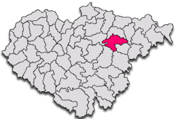
 Location within Sălaj County | |
 Surduc Location within Romania | |
| Coordinates: 47°15′18″N 23°20′52″E / 47.25500°N 23.34778°ECoordinates: 47°15′18″N 23°20′52″E / 47.25500°N 23.34778°E | |
| Country |
|
| County | Sălaj County |
| Documentary attestation | 1554 (Naghzwrdok)[1] |
| Government | |
| • Mayor | Alin Băbănaș (PNL) |
| Area | 71.42 km2 (27.58 sq mi) |
| Elevation | 607 m (1,991 ft) |
| Population (2002)[2] | 4,026 |
| • Density | 56.37/km2 (146.0/sq mi) |
| Time zone | EET (UTC+2) |
| • Summer (DST) | EEST (UTC+3) |
| Website |
www |
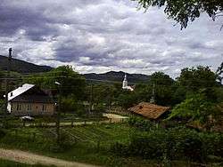
Surduc (Hungarian: Szurduk) is a commune located in Sălaj County, Romania. It is composed of seven villages: Brâglez (Tótszállás), Cristolțel (Kiskeresztes), Solona (Szalonnapatak), Surduc, Teștioara (Kőszénbányatelep), Tihău (Tihó) and Turbuța (Turbóca).
Physical-geographical data

Defining features of the landscape in the commune of Surduc are the result of selective modeling of geological substratum, consisting of sedimentary rocks of different resistance and arranged in an obvious monoclinal structure.
The relief is very varied, consisting of a combination of hilly peaks and valleys between slopes, all resulted from fragmentation of the northwestern part of Someș Plateau. Altitudinal, relief ranges from about 200 m in Someș River meadow and maximum altitude of 607 m in Pietrosu Peak in the southeastern part of the commune. Energy of landscape has considerable value, between 200–300 m and even 400 m, in relation to depression areas, which explains, in some measure, the intensity of slope processes.
Vertical deepening of the valleys is relatively high, determined by geological structure (layers consisting of sandstones, clays, marls, conglomerates etc.). Vertical deepening is accompanied by an active torrential erosion, mitigated or stabilized by the level of afforestation. The commune is crossed by three major subunits of relief: Șimișna-Gârbou Hills, Prisnel Peak and Almaș-Agrij Depression, all running across the Someș Corridor. This leads to a very pronounced transition for relief and other geographic components, giving a note of specificity to geographical area of the commune.
Climatic aspects
In the studied perimeter is no meteorological station, therefore to characterize the climate we used data from the meteorological station of Plant Protection Centre Jibou, with a series of observations for 20 years (1966-1985). We also used some generalizations contained in Climatological Atlas, the RSR Atlas, or some works referring to Sălaj County (1972).
Climato-genetic factors
Factors that have a direct influence on variation in time and space of climatic elements are: solar radiation, dynamics of atmosphere and adjacent surface.
Direct solar radiation has a value, for the studied territory, of 110-115 kcal/cm²/year, characteristic to the latitude, covering energy needs.
General circulation of the atmosphere is given by the position and intensity of major barrel systems of the continent (Azores High, Icelandic Low, Siberian High, Mediterranean cyclones), with greater frequency of western circulation. The territory is affected by different air masses, greater frequency having:
- polar-maritime air masses, in late spring and summer months, Are cold and wet, transported by western and northwestern circulation;
- polar-continental air masses, cold and dry in winter, hot and dry in summer; arisen from east and northeast;
- arctic-maritime air masses pervade from North Atlantic Ocean, within the pale of polar circulation. Determine frosty weather and relatively wet in winter, and in spring and autumn frosts;
- tropical-maritime air masses, that pervade from the south and southwest, determine during the winter mists and heavy snow falls, and in summer determine atmospheric instability;
- tropical-continental air masses, with low frequency, are transported by southern, southwestern and southeastern circulation. It is most common in summer, when give rise to tropical days.
Underlying surface, by which means the land area with all its characteristics (morphological, hydrographic, biopedogeographic etc. influenced or not by anthropic activity) has an active role in transforming solar radiant energy into heat, generating all climate processes and phenomena resulting from the lower layer of air. Peculiarities of active area have a particular importance in the formation of specific topoclimates and microclimates.
Hydrographic aspects
After genetic characters, waters within the commune of Surduc fall into three broad categories: streams with permanent or temporary flow which forms the hydrographic network, stagnant waters (lakes) and aquifer layers quartered in gravel and sand horizons located at different depths forming groundwater that in many places appear as springs.
Surface hydrographic network

The hydrographic network draining the commune of Surduc area is relatively young in age. It is represented by the Someș River, allochthonous river of national importance, main collector of all surface waters in the commune of Surduc and a series of lesser tributaries that integrates to Someș hydrographic system, such as: Almaș, Brâglez, Solona, Valea Hrăii. The average density of hydrographic network (taking into account the length of the valley with temporary character) is 0.39 km/km2.
The proper Someș River is considered from Dej, after the joining of Someșul Mare with Someșul Mic. It crosses to northwest the Someș Plateau, almost symmetrically receiving tributaries, both from Cluj and Gârbou Hills, and from Ciceu Hills. Someș crosses through the village to the north-northwest, entering from Cliț–Ciocmani and gets out of the commune in the Turbuța–Var sector. Between Surduc and Jibou it traverses a probable local subsidence area receiving a bunch of tributaries converging to the center of the area: Valea Hrăii, Solona, Gârbou, Almaș, Agrij and Sărata (last two in the town of Jibou).
Demographics
| Historical population | ||
|---|---|---|
| Year | Pop. | ±% |
| 1850 | 2,646 | — |
| 1880 | 2,616 | −1.1% |
| 1890 | 2,920 | +11.6% |
| 1900 | 3,108 | +6.4% |
| 1910 | 3,841 | +23.6% |
| 1920 | 3,743 | −2.6% |
| 1930 | 4,707 | +25.8% |
| 1941 | 4,891 | +3.9% |
| 1956 | 5,671 | +15.9% |
| 1966 | 5,516 | −2.7% |
| 1977 | 4,805 | −12.9% |
| 1992 | 4,323 | −10.0% |
| 2002 | 4,026 | −6.9% |
| 2009 | 3,754 | −6.8% |
| 2010 | 3,719 | −0.9% |
| 2011 | 3,415 | −8.2% |
| Source: "Erdély etnikai és felekezeti statisztikája", Kulturális Innovációs Alapítvány (in Hungarian) | ||
| Village | Population |
|---|---|
| Brâglez | 353 |
| Cristolțel | 460 |
| Solona | 288 |
| Surduc | 1,367 |
| Teștioara | 100 |
| Tihău | 1,080 |
| Turbuța | 378 |
| Commune of Surduc | |
At the census of March 18, 2002, the population of Surduc was 4,026, ranking sixth in Sălaj County. Since the 1990s, residents have migrated to urban areas, but the population has nevertheless risen slightly due to natural increase. Additionally, there has been significant emigration to Italy, France, Germany, Spain, the United Kingdom, the United States and other countries in Western and Southern Europe.[3] In terms of population stratification by gender, the commune of Surduc integrates 1.937 men (48.11%) and 2.089 women (51.89%). People under 15 years constituted 16.99%, while people over 59 years formed 27.72% of total population, denoting an acute enhancement of the senescence of population. In 2002, population density in the commune was 48.8 inhabitants per km2.[4]
Religious structure
Most inhabitants (3588) are Romanian Orthodox. In the 19th century, the Greek-Catholic Church was predominant, with 605 adherents in 1900. That church was banned under the Communist regime from 1948 to 1989, and has not regained its former position.
Ethnic structure
At the 2002 census, 97.07% of inhabitants were Romanians, 2.63% Roma, 0.27% Hungarians and 0.02% Poles. Jews and Germans formerly resided there as well. Likewise, the population of commune includes several unsettled Romanian Italian residents, that return, for a short period of time, in places of origin.[5]
Documentation
.jpg)
Surduc is documented since 1554, when it appears as Nahyzwrdok. Other documentary attestations accrue from years 1625 Nagi Szendok, 1630 Nagy-Szurduk, 1733 Szurduk, 1850 Szurdok, Szurduku, 1854 Szurduk, Surduc, 1930 Surduc, 1966 Surduc. Nevertheless, first documentary attestation of Turbuța dates from 1387, when the village appears as villa olachalis Torbicza.
The name of commune stems from the morphological configuration of the place (surduc = defile, pass, narrow valley with steep and swift slopes). Surduc is the gateway to the east or west by Someș valley gorge and also a gateway to Valea Gârboului, Poiana Onții and Valea Solonei, to Solona, Teştioara and Văleni.
Although first documentary attestation in 1554, were found references from 1544 to the commune of Naghzurdoc – from the Slavic word "surdec" meaning "bend" and stems from the fact that in the locality, the Someș River makes the biggest turning point in its course.
Tourism

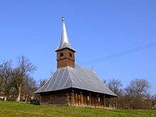
The commune of Surduc is an exponent for cultural tourism, strictly linked to the presence in the county of cultural values that can take different forms. Worthy of interest are folkloric festivals, rustic and pastoral celebrations organized in Sălaj County, that attract thousands of spectators annually. Location of the commune in a picturesque and clean environment, as well as varied relief and unmistakable hospitality confer it an inimitable tourist dowry. Valea Hrăii area is renowned nationally and disposes of a high tourism potential conferred by the landscape, flora and especially fauna. The Sălaj County is nicknamed Wooden Churches County (Romanian: Judeţul Bisericilor de Lemn, Hungarian: Fa Megyei Egyházak) and includes many protected areas of national interest, so this is an area of substantial attraction, due to landscape areas, churches, monasteries, and other attractive sights.[6]
A Roman fort was discovered near Tihău village.
Notable figures
- Miklós Jósika (1794–1865), Hungarian writer
- Vasile Puşcaş (born 1952), Romanian professor, diplomat, and politician
References
- ↑ Commune of Surduc Hall - Locality history
- ↑ Romanian census data, 2002; retrieved on March 1, 2010
- ↑ Commune of Surduc Hall - Population
- ↑ Commune of Surduc - Population by gender and age groups
- ↑ Ethnocultural Diversity Resource Center - Ethno-demographic structure of Romania (2002)
- ↑ Commune of Surduc Hall - Tourism
External links
- (in Romanian) Broad overview of the commune of Surduc
